Hike with Gravity Home Page

Main navigation

  • Hikes
    • Appalachian Trail 2017
    • Pacific Crest Trail 2019
    • Continental Divide Trail 2021
    • Benton MacKaye Trail 2020
    • Art Loeb Trail 2021
    • Pinhoti Trail 2022
    • Foothills and Bartram Trails 2022
    • Appalachian High Route 2023-24
    • Arizona Trail 2024
    • Long Trail 2025
  • About
    • Gravity
    • My Trail Name
    • My Triple Crown Hikes
    • This Site
    • The Appalachian Trail
    • The Pacific Crest Trail
    • The Continental Divide Trail
    • The Benton MacKaye Trail
  • Gear
    • Hiking
    • Shelter and Sleep System
    • Clothing and Shoes
    • Cooking and Water Filtration
    • First Aid, Hygiene, Miscellaneous
    • Electronics
  • Contact
  • Newsletter
Pacific Crest Trail

Pacific Crest Trail 2019

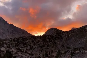
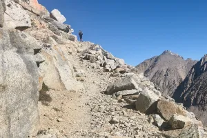
I started my PCT thru-hike at the southern terminus on March 24, 2019. Although I needed to take a long break because of unusually heavy snow in the Sierra Nevada, I completed the entire trail and finished on October 25.

Page 6

Day 120, Tentsite at Mile 1071.6 to Sherrold Lake

Jagged rocks of Reynolds Peak

Day 121, Sherrold Lake to Carson River

Rocks that look like Stonehenge

Day 122, Carson River to Kennedy Canyon Creek

View of mountains in the High Sierra

Day 123, Kennedy Canyon Creek to Wilma Lake

Approaching Stella Lake

Day 124, Wilma Lake to Tentsite near Volunteer Peak

Red breasted nuthatch

Day 125, Tentsite near Volunteer Peak to Tentsite at Mile 951.1

Alpenglow on Cathedral Peak in Yosemite

Day 126, Tentsite at Mile 951.1 to Tuolumne Meadows

View of Fairview and Cathedral peaks

Day 127, Tuolumne Meadows to Rush Creek

Lyell Fork near Donohue Pass

Day 128, Rush Creek to Red’s Meadow

Island Pass

Day 129, Red’s Meadow to Fish Creek

Blue sky over Purple Lake

Day 130, Fish Creek to Bear Creek

Direction sign near Silver Pass on the PCT

Day 131, Bear Creek to Tentsite near Muir Trail Ranch

The PCT heads to Marie Lake

Day 132, Tentsite near Muir Trail Ranch to Sapphire Lake

Sapphire Lake and Mt. Huxley in Kings Canyon National Park

Day 133, Sapphire Lake to Middle Fork Trail

Clouds over Le Conte Canyon

Day 134, Middle Fork Trail to Tentsite at Mile 809.6

Descending southbound from Mather Pass

Day 135, Tentsite at Mile 809.6 to Rae Lakes

A hiker descends from Pinchot Pass

Day 136, Rae Lakes to Independence

Sunrise above Rae Lakes

Day 137, Independence to Bubbs Creek

A mule deer looks up

Day 138, Bubbs Creek to Whitney Creek

Climbing to Forester Pas

Day 139, Whitney Creek to Dutch Meadow

Burnt trees

Day 140, Dutch Meadow to Cow Creek

A PCT emblem nailed to a tree

Day 141, Cow Creek to Kennedy Meadows

A PCT sign nailed to a tree

Days 142-144, Flipping Again

A road map

Day 145, Ashland to Grouse Gap

Snow-covered trees

Pagination

  • First page |<
  • Previous page <
  • …
  • Page 3
  • Page 4
  • Page 5
  • Current page 6
  • Page 7
  • Page 8
  • Next page >
  • Last page >|

Social

  • Follow:
  • Instagram
  • Facebook
  • Bluesky
  • Mastodon
  • Threads
  • RSS

Footer

  • Hikes
  • About
  • Gear
  • Contact
  • Newsletter
Hike with Gravity

Copyright 2017 - 2026 by Jim "Gravity" Smith

Creative Commons

Unless otherwise noted, all content on this site was created by Jim Smith and is licensed under a Creative Commons Attribution-NonCommercial 4.0 International License.

This site was designed and built by Starting Gravity using the open-source project Drupal.