
Day 133 Sapphire Lake to Middle Fork Trail
More from this trailWind yells among the stone
I've written before about the reasons behind my flip-flopping on the trail. I'm hiking in the Sierra now to avoid the added risks that could come with bad weather in this section.
I knew my flipping wouldn't avoid harsh weather conditions entirely. Snow, lightning, and high winds are common here at any time of year. I was only trying to hike when the risk was less.
Today offered a small hint of those conditions. Thankfully, they were minor compared to what might be possible.
Our campsite near Sapphire Lake was at about 11,000 feet above sea level. Because of the elevation, I wasn't surprised when I woke to a temperature near freezing.
At first, the morning sky looked much like yesterday evening's sky, with a few wispy clouds. This view quickly changed.

Leaving Sapphire Lake
The sun wasn't yet above the nearby mountains when I left the campsite. Soon, the wind began to pick up.

Sun and clouds over the JMT and PCT
As the sun rose, clouds moved in. The trail steadily climbed to Muir Pass, which was just under 12,000 feet. As I walked this gradual ascent, the temperature noticeably dropped.

A view of Mt. Mendel, Mt. Darwin, and Mt. Huxley
I turned to look back to see Mt. Mendel, Mt. Darwin, and Mt. Huxley, the mountains I had seen yesterday evening from our campsite. They looked bleak now, much different than when they were lit by the setting sun.

Wanda Lake and Mt. Solomons
After walking for about an hour, I reached Wanda Lake. By now, more clouds had moved in to block out the sun.
The lake was named for the eldest of John Muir's two daughters.
Mt. Solomons stood behind the lake. Theodore Solomons was one of the men credited with mapping the route that became the John Muir Trail. He surveyed this area in 1896 and named many of the mountains along Evolution Creek and the South Fork of San Joaquin River.

Climbing to Muir Pass
The last mile of the climb to Muir Pass was rocky and much steeper, ascending 415 feet.
By now, the temperature had dropped to well below freezing. The wind became gusty.

Ice on the trail
Patches of ice appeared on the trail. It wasn't slippery because it crunched into granules like rock salt when I stepped on it.

Looking back to Wanda Lake
As I got near the top of the climb, I turned to look back at Wanda Lake. The weather conditions were quickly changing, and for a moment, it looked as though the lake was already freezing solid.
This appearance came from the clouds building overhead and making the sky darker. The ground and lake turned flat shades of bone grey.
The wind was blowing much stronger now. I estimated some of the gusts were 30 mph.

Reaching Muir Pass
Muir Pass was a gap in the Goddard Divide, a ridge that separated the South Fork of San Joaquin River from the Middle Fork of Kings River.
A small stone hut with a pointed roof appeared as I made the final approach to the pass. Sierra Club members constructed the round structure in 1930. They intended it to be an emergency shelter for climbers and hikers.

Stone hut at Muir Pass
Bluejay was already gone by the time I arrived at 9:35 a.m. She must not have wanted to hang around because of the blustery-cold weather.
I went inside and met a couple of northbound hikers who were nearly ready to leave. The granite rock hut wasn't what you would call cozy. Still, I was out of the wind and decided to stay for a few minutes to boil water for coffee and oatmeal.

Looking south from Muir Pass
After staying for about 45 minutes, I finished repacking and prepared to leave. Looking south from the pass, I saw to my left a stark and impressive mountain called Black Giant. A ridge extending from Mt. Solomons was on my right.

Looking north from Muir Pass
Turning around to look north, the mountains I saw as I walked up to the pass now looked dark and imposing. Thick clouds above me made the whole range appear menacing.

Looking north from Muir Pass with sleet moving in
Then while I stood there, this scene made a remarkable change. In less than two minutes, the mountains became barely visible as a wall of sleet began to fall and move toward the pass.
Thankfully, the sleet didn't fall for long, though it briefly returned as I began to walk down the other side of the pass.

Snow over the trail near Muir Pass
Near the top, the trail passed over a small pile of snow. A path made by previous hikers was easy to follow, but it wasn't directly over the trail.

Near the headwaters of the Middle Fork of Kings River
The trail dropped to Helen Lake, part of the headwaters of the Middle Fork of Kings River.
The river was called El Rio de los Santos Reyes (River of the Holy Kings) by Gabriel Moraga, who also named the San Joaquin River during his explorations. The middle tributary is 37 miles long.
The trail followed the river downstream. The sleet had cleared by now, but the clouds remained with cold and gusty winds.

Waterfall in Le Conte Canyon
From Muir Pass to the bottom of the 11-mile descent, the trail dropped nearly 4,100 feet. The river was a rushing cascade as the water plunged into Le Conte Canyon.

A view of Le Conte Canyon
The canyon was carved by glaciers, not the river. It was named to honor Joseph N. Le Conte, who served the Sierra Club in many capacities. He was the organization's second president after John Muir.

The sky begins to clear over Le Conte Canyon
The sun finally appeared again around 1:30 p.m. The wind had also died down. By this time, I had walked much deeper into the canyon.
I caught up to Bluejay when she stopped to take off a jacket because of the warmer weather. We walked together for a short time until I decided I needed to stop for lunch.

Stopping for lunch
Bluejay continued hiking when I stopped at a small campsite. I didn't notice at first an unusual feature located here but saw it when I went to filter water.

A rock made to look like a whale or monster
A large boulder that had split in two was there. A clever person had lined up small stones on the lower part of the boulder to look like teeth. Two more stones were placed in indentations on the boulder's sides, giving it "eyes." These additions made the formation look like a whale or giant monster.

Langille Peak
After dropping continuously for more than 1,800 feet, the trail leveled for a short distance as it entered Big Pete Meadow.
Standing at one side was Langille Peak. Its 276-foot prominence rose straight up from the meadow floor.

A mule deer wanders in Big Pete Meadow
My walk through the meadow was interrupted by a mule deer. It paid no attention to me as it grazed on the trail. After about a minute, it finally moved nonchalantly to one side so I could continue on my way.

A lower view of Le Conte Canyon
Although the trail began to descend again after I left Big Pete Meadow, the drop wasn't as steep. There were more meadows ahead.
The sun was shining brightly now, and there were no more wind gusts. The day had become much more pleasant.
A northbound JMT hiker told me a trail maintainer had said rain was in the forecast for tonight. I was a little skeptical, though, based on the way the sky looked. The few clouds remaining in the sky didn't look to me like rain clouds.

Grouse Meadows
I cruised through Grouse Meadows at 5 p.m. By now, the descent along the long canyon was so gradual it was barely noticeable. I was nearing the bottom, where the trail would begin a climb out of the canyon.
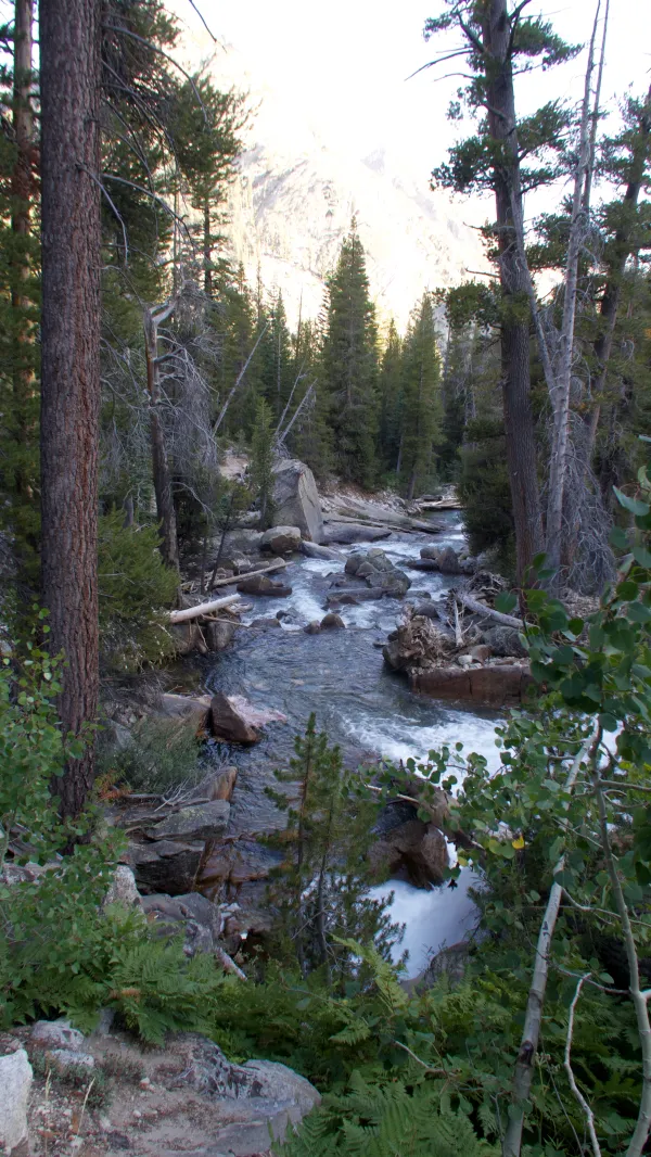
Middle Fork of Kings River
When I reached the bottom 30 minutes later, the trail made a turn to the left because the river made a turn.
At this point, I expected to have nearly three more miles to go to tonight's campsite. Then I noticed Bluejay's bandana hanging on a sign for the Middle Fork Trail. This was her signal to me she had stopped for the day.
Walking a short distance down the trail, I found where she had set up her tent. She told me she had become too tired to go farther.
When I saw her this afternoon on the trail, she mentioned she was feeling tired. I wondered if she had a calorie deficiency, similar to what slowed me for a couple of days before we stopped at Muir Trail Ranch.
Although I wasn't tired today, I didn't mind stopping early. While we ate dinner, we looked at the trail ahead and decided we could probably make up the lost miles tomorrow.
The only reason we intended to go farther today was that we knew some difficult miles were coming up.
Bluejay was always a strong hiker, so it was unusual for her to tire out. Although I was a little concerned about her, I thought if she kept up her calorie intake as I had to do, we could stay on or ahead of schedule.
The way I figured, each day we saved now meant one less day later that might be in winter weather.
Then I remembered the JMT hiker telling me about a prediction of rain, so I downloaded the weather forecast on my Garmin InReach Mini. It said there was only a ten percent chance of precipitation. Things were looking better already.
Last leaf fallen, bare earth where green was, bone
Above Madonna, two eagles hang against a cloud
Sun comes up blood red
Wind yells among the stone
All graceful instruments are known
This trail report was published