
Day 127 Tuolumne Meadows to Rush Creek
More from this trailThere's a chill in the meadow of bottomless time
From today until we finish the Sierra section of the PCT, Bluejay and I will need to be more aware of the trail's elevation profile. It will go above 10,000 feet for most of the way. Six mountain passes will climb well over 11,000 feet, with one going above 13,000 feet.
The passes require special attention because big elevation changes are more strenuous. There could also be weather considerations because the high passes are dangerous in a thunderstorm.
When we began hiking this morning, the trail began with about nine miles of easy walking through Tuolumne Meadows and Lyell Canyon. This section was nearly flat, rising only 200 feet from beginning to end.
We expected the morning would begin cold, but the temperature didn’t seem to drop to 23 F, as the forecast said it would. I didn't see any frost or frozen water when I crawled out of my tent. I slept warmly last night but the day began with a frigid start.

Lembert Dome in Tuolumne Meadows
Bluejay and I left the campsite together at 7 a.m., though it didn't take me long to fall behind.
I stopped to take photos, which required taking off, then putting on a pair of socks I was wearing for extra insulation on my hands. Knowing the temperature in higher elevations would be even colder, I regretted I won't receive my mittens until I reach the trail town of Independence in several days.
The first photos I took were of Lembert Dome, standing near a bridge crossing the Tuolumne River. A short distance upstream of the bridge was where two streams, Lyell Fork and Dana Fork, joined to form the river.
Lembert Dome was named for John Baptiste Lembert, who built a cabin nearby in 1885 and filed a claim for his land under the Homestead Act.

Crossing Tuolumne Meadows
Once I was back on the PCT, I followed it through the remainder of Tuolumne Meadows along the Dana Fork of the Tuolumne.
This area was named by Josiah Dwight Whitney, a geologist with the California State Geological Survey. One source says he named it for a nearby tribe named Tawalimni, Towolumne, or Tuolumne, but another says the name comes from the Miwok tribe's word for “squirrel.”
Native Americans began using the meadow at least 4,000 years ago as a stopover on their trade route between the eastern and western slopes of the Sierra mountains.
A young Scotsman named John Muir came here for the first time in 1896 while working as a shepherd. To kill time while the sheep grazed, he explored the surrounding mountains and fell in love with their beauty.
Muir soon became an instrumental member of a movement to make the Yosemite area a national park, which happened in 1890. Two years later, he helped found the Sierra Club and became its first president. The original purpose of the organization was to protect the park and encourage its enjoyment.

Eroded trail in Lyell Canyon
The temperature gradually warmed while I walked, and by 9 a.m. I stopped to remove the extra layer of clothing I was wearing. I also no longer needed to use my spare socks as mittens.
By this time, the trail had crossed Tuolumne Meadows to the Lyell Fork, then left the meadows to go upstream into Lyell Canyon. The PCT was now following the same footpath as the John Muir Trail and I was beginning to see backpackers who were hiking that trail. The JMT extends from Yosemite Valley to Mt. Whitney, if going southbound, which is the direction most hikers walk. It is 211 miles long and the PCT shares about 160 miles of that distance.
The idea for the JMT is sometimes credited to Dr. Joseph N. LeConte. He was a professor of geology and natural history at the University of California and an early member of the Sierra Club. The proposed route was based on his surveying and mapping work.
The Sierra Club has distanced itself in recent years from its association with Muir and LeConte because of their racist views.
Although Mt. LeConte in Great Smoky Mountains National Park is also credited to his name, some historians claim the mountain was named for his brother, John.
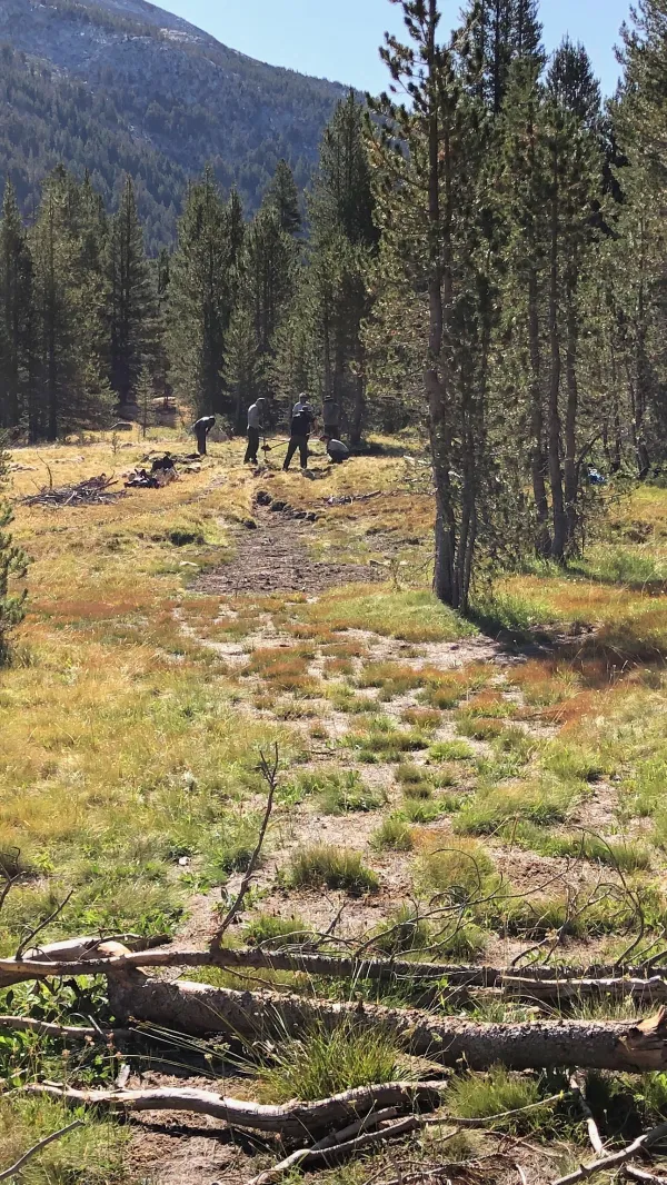
Crew moving trail in Lyell Canyon
Development of the JMT began in 1915 and was completed after 23 years of work.
As with any trail, regular maintenance is needed. In a large meadow of the canyon, I saw a crew working to move the trail to more durable terrain.

Improved trail in Lyell Canyon
Where their work was already completed, the trail was wide, smooth, and designed for better drainage.
In this section, I met an elderly couple backpacking northbound. Though they were walking very slowly, I smiled in admiration of their desire to be in the wilderness.

Wide meadow in Lyell Canyon
As I walked along the Lyell Fork, a ridge of distant mountains came into view. The trail was going in that direction and would climb Donohue Pass on that ridge.
Seeing snow on the mountains, I hoped the hikers who told me I didn't need microspikes were correct.

Lyell Fork
The Lyell Fork and the canyon were beautiful. The stream snaking through the canyon wasn't deep but was sometimes wide.
This part of the trail was especially enjoyable because the flat and smooth footpath made it easier to see all of the canyon without stopping.

Nearing the end of Lyell Canyon
When the trail reached the end of the flat canyon, it began a steep climb while still following Lyell Fork. I stopped for lunch just before starting the climb, next to the stream.

Climbing to Lyell Pass
The climb immediately became steep and remained steep most of the way up the 2,200-foot climb in the next 3.9 miles.
I passed a hiker struggling up the climb with a heavy pack and immediately realized he was not a PCT thru-hiker. He told me with obvious regret he was carrying too much. This was a bad spot to figure that out, I thought but didn't say out loud.

Looking back to Lyell Canyon
Along the way up, I occasionally turned around to look back at the view of Lyell Canyon. Mt. Conness and Sheep Peak stood about 15 miles away, where they overlooked Tuolumne Meadows.

Looking toward Donohue Pass
There were some false summits on the climb to make me think I was nearing the top. When I crested these, I would see the snowy range of mountains was still ahead.

The upper Lyell Fork
The climb was closing in on the headwaters of Lyell Fork. Though the stream was a gentle flow with wide pools, I could imagine it overflowing with snowmelt in the spring and early summer.

Steps in the upper Lyell Valley
I had not expected to see rock steps built in the trail at this elevation and so far from the trail where day hikers might walk. They were just one example of the care put into maintaining this old trail.

Another look back to Lyell Canyon
At another false summit, I turned to look back again. To my right was the rounded granite hump of Mammoth Peak.

Dark clouds above Donohue Pass
I was finally approaching Donohue Pass at 3:30 p.m. This part of the climb was rocky in places, but there were again a few steps to make the climb easier.
Ominous dark clouds were forming overhead. They didn't threaten a thunderstorm, but I thought rain was a possibility. Thankfully, none fell.

Gravity on Donohue Pass
When I reached the top of the pass, I was surprised to discover I could receive strong cell service, so I took a selfie and sent it to Kim. I also checked the forecast for the coming week. It showed low temperatures staying around freezing. Though no rain was predicted, a chance of snow was shown for early next week.
The weather was blustery while I stood at the top of the pass, so I didn't stay there for long.

Looking south from Donohue Pass
At the pass, I crossed the boundary of Yosemite National Park and entered Ansel Adams Wilderness. It covers 232,000 acres.
The wilderness area was originally called Minarets for some of the granite spires and outcroppings. It was renamed in 1984 to honor the renowned landscape photographer and environmentalist, who died that same year.
I had less than four miles to go to reach the campsite Bluejay and I had selected but didn't know how long the descent would take. From the look of the slope and the rocks, it appeared that it might be slow going.

Minarets in Ansel Adams Wilderness
The first part of the descent turned out to be easier than expected. That didn't last all the way down, however. The trail was occasionally littered with a jumble of rocks.
The dark clouds remained, though not as thick as earlier. They hung over Banner Peak, which stood 4.2 miles away with its nearby neighbor, Mt. Ritter. These peaks are part of a range that gave the wilderness area its original name, Minarets.
Gaps of blue sky were a welcome sign there wouldn't be any rain.
On the way down, a hiker climbing northbound told me I was about one hour behind Bluejay. She asked him to pass along a message to confirm she planned to stop at Rush Creek, which was where we had discussed stopping.

Approaching Rush Creek
The trail crossed Rush Creek and small feeder streams more than once. It was a nice, scenic area with little waterfalls and large boulders.
In his authoritative book published in 1911, "Yosemite Trails," English-American travel author and adventurer J. Smeaton Chase described Rush Creek as "handsome."
"We were to keep it company for some days, and excellent company it proved to be," he added.
I had to agree. The stone steps on the trail leading to the creek added to the park-like landscape.

A small waterfall on Rush Creek
I got to where Bluejay had set up her tent at 5:45, which was 15 minutes sooner than the NOBO hiker with her message had estimated. Because of the boulders scattered in the area, we didn't realize until later that other hikers were camped nearby.
Chopped olive sandwiches, roses, and wine
Cold ripe persimmons, my sweet Clementine
There's a chill in the meadow of bottomless time
I go on, I go on, I can't fill my cup
There's a hole in the bottom, the spring has dried up
Just a thought for the moment, it never was mine
Just like a [fat through] and cut past the vines
I run through the forests of linear time
This trail report was published