
Day 130 Fish Creek to Bear Creek
More from this trailYou can't overlook the lack, Jack, of any other highway to ride
Though it wasn't directly on the PCT, Red's Meadow Resort was only about three-tenths of a mile from it. When I left the resort yesterday morning, the road there was the last one to cross for the next 200 miles. The trail will not cross another road until I get near Kennedy Meadows at the south end of the Sierra.
Not having roads near the trail is nice for a wilderness experience but adds to the challenges of hiking. The options to bail out or resupply are much more limited and difficult to reach.
Although Bluejay and I are no longer hiking with Sunkist, we are still benefiting from her experience hiking this section. She laid out a plan that helped us avoid long stretches between resupply stops. The shortened distances are allowing us to reduce our pack weight.
We're surprised, however, to discover we're going faster than Sunkist's plan presumed. The schedule included a stop at Vermillion Valley Resort (VVR), but we will pass that today without stopping. We're also starting to wonder if we will get to Independence sooner than expected.
Independence is our one resupply stop that will require a hike several miles away from the PCT, then a long car ride into town. We've already booked a shuttle to pick us up at the trailhead but have a few more days before we need to be concerned about getting there too soon.

A bridge crossing Fish Creek
This morning was chilly but not freezing. It's hard to know sometimes whether camping in a valley will be better for the temperature or not. Sometimes, and especially when near water, cold air will settle in lower elevations.
If we had camped at Lake Virginia as originally planned, we would have been at 10,354 feet and near a large lake. Instead, we were camped 840 feet lower than that and surrounded by more trees. Most likely, our campsite on Fish Creek was warmer than Lake Virginia.
Less than a mile from our campsite, the trail crossed a sturdy bridge over the creek. Then two-tenths of a mile farther, the trail began a long and sometimes steep climb away from the creek.

Blazed tree
The climb was 1,749 feet in the next 3.4 miles. On the way, I saw some unusual notches carved in trees. These were probably cut with an ax to mark the trail.
Blazing a trail like this was a practice for centuries, though now mostly abandoned. Blazes today are usually painted, like the Appalachian Trail's two-inch by six-inch white rectangles, or metal or wooden emblems attached to trees. The PCT generally uses the latter method.
Some carved blazes like the ones I saw today were made by U.S. Cavalry soldiers. They patrolled this area before the creation of the National Park Service and Forest Service.
In the 1890s, cavalry patrols were based at Red's Meadow but I don't know if the blazes I saw were made by those soldiers. They often blazed trees with a "T" and joked this mark was used so "Irishmen in the army would know that it was a tree.”

Sun comes over a ridge
The climb leveled for a short distance in a glacial valley. The sun was now rising above the valley's rim and the temperature was warming.
I stopped to remove my insulating jacket and eat a snack. I also filtered some water at a nearby stream.

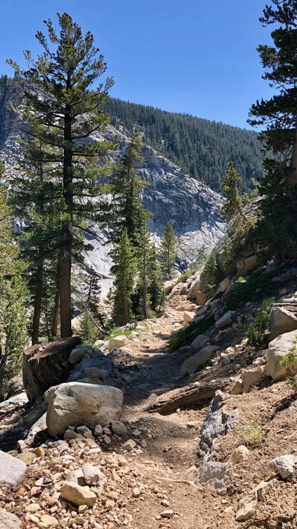
A rugged climb on the PCT
The trail became more difficult as it climbed over broken rocks and reached a higher part of the valley.

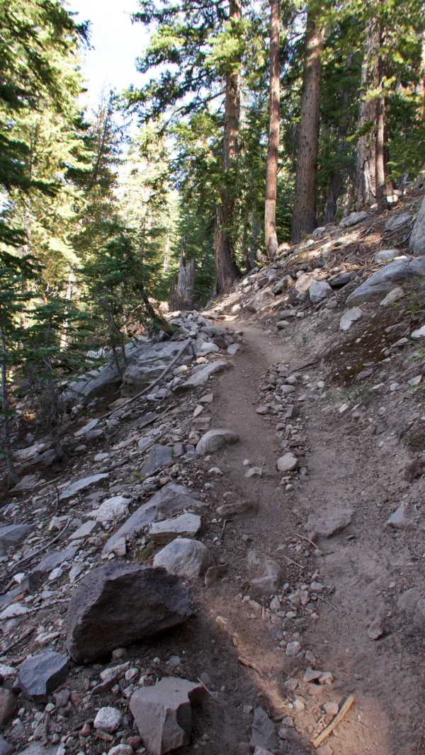
Smooth trail on the PCT
Once the trail passed the scree slope it became much smoother. As I continued walking, I wondered where the trail would go. No obvious pass appeared ahead between the steep and rugged walls of rock.

Near Squaw Lake
The trail didn't go straight as I had expected. Instead, it jogged to the left and climbed the side slope of the valley. It then turned to cross a stream flowing from Squaw Lake. This was at the cirque of this glacier-carved valley.
More climbing followed before the trail leveled briefly where it reached Goodale Pass at 10,540 feet, then continued upward.

a view from Silver Pass
The trail crested at nearly 11,000 feet before dropping 150 feet to Silver Pass.
This spot offered an outstanding view of where the trail would be heading later today. Two of the prominent peaks on the left were Recess Peak and Seven Gables.
In a direct line from where I stood, Recess Peak was 7.1 miles away. It was 12,813 feet in elevation. Beyond it at 12 miles away was Seven Gables. Its peak was 13,060 above sea level.
Our campsite for tonight was at the foot of both mountains and about halfway between them. By trail, it was more than 13 miles away from Silver Pass.
Descending trail on the PCT
The next 6.4 miles were all downhill, dropping 3,100 feet. The first part of the descent was not steep. Later, it became much steeper as it neared Mono Creek. This section was a drop of 550 feet in six-tenths of a mile.
I was hungry and thirsty when I reached the bottom of the descent at North Fork Creek, so I stopped for a late lunch. Then after resuming my hike, I realized I had somehow dropped my bandana. I walked back and found it nearby.
A short distance from the creek was a side trail that led to Lake Edison. Hikers wanting to go to Vermillion Valley Resort will take that trail to a boat dock on the lake. A water taxi will pick them up there and take them to the resort.
Although Sunkist's hiking plan included a stop at VVR, Bluejay and I didn't need another resupply yet. The taxi only made two trips a day to the resort, so if I had wanted to go there I would be sitting on the dock for several hours.
Climbing trail on the PCT
Feeling strong after my lunch break, I powered up the second climb of the day. This one didn't quite reach 10,000 feet in elevation but was a continuous ascent of 2,100 feet in 3.3 miles.

A view of Seven Gables
I arrived at the top at 5:30 p.m. and stopped to enjoy the view. Seven Gables was now just 6.5 miles away.

Bear Creek
With just 2.7 miles to go and mostly downhill to end the day, I should have felt strong and upbeat. Instead, I started to feel my energy drain away. I arrived at our campsite just before 7 p.m., which was about the time I would have expected, but I was worn out.
Perhaps the 4,000 feet of ascending and 5,000 feet of descending trail had something to do with that.
I may need to take another look at my calorie consumption to get me through the Sierra. There are more than 165 miles of roadless trail ahead before we reach the end of this section. In that distance, we'll make two resupply stops. They will give me a chance to load up on a few extra snack bars.
You can't overlook the lack, Jack
Of any other highway to ride
It's got no signs or dividing lines
And very few rules to guide
I spent a little time on the mountain
Spent a little time on the hill
I saw things getting out of hand
I guess they always will
This trail report was published