
Day 14 Piercy Creek to Sassafras Gap Shelter
More from this trailWe've been through some things together
Today could have been our last day of hiking. I briefly entertained that idea before Polecat and I started on the trail this morning.
We had less than 11 miles to go to reach the end of the Blue Ridge Bartram Trail. That couldn't be the end of our hike, however, because the trail's terminus is at the top of Cheoah Bald, a 5,062-foot tall mountain with no road access. To complete our hike, we must hike down the mountain on the Appalachian Trail to where we left Polecat's truck. That adds 6.7 miles to the hike and it is all downhill.
Though for a moment, hiking the full distance seemed possible, I soon realized this was a foolish idea.
Our campsite for last night was at 2,875 feet in elevation. If we could climb from there directly to the top of Cheoah Bald, it would be a gain of 2,200 feet. Going that high in one day would not be overly strenuous.
We were not going to be so lucky. Instead, we had to start with a 900-foot climb, then would lose all of that elevation and 900 feet more. To get to the top of Cheoah Bald, we had to go up nearly 3,330 feet in one continuous climb.
In total, this was a 5,247-feet day of climbing. Looking at it that way, I can't imagine what made me think adding 6.7 miles to the day would be possible.

Polecat leaves the campsite
I woke up to cool but comfortable weather. The sky was overcast, and I wondered if we would get rain today.
Polecat and I didn't need much time to pack, and we were on the trail well before 8 a.m.
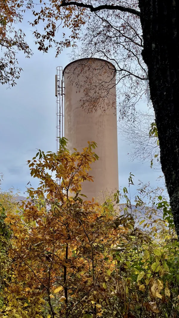
A standpipe
The first climb wasn't difficult, and we soon began the descent, which took us down to the Nantahala River. Before reaching the bottom, we passed a standpipe that stood starkly among the oak, hickory, beech, and maple trees.
The tall, metal pipe is also called a surge tank. It was placed near the bottom end of a water diversion system for hydro-electric generation. The water managed by this standpipe came from a dam on the other side of the cove at Queens Creek.

Descending a gravel road
The trail joined a gravel road used by maintenance crews to access the standpipe, making part of the descent smooth and easy.

Beechertown
As I neared the bottom, I could see the power station where electricity is generated and the pipe that brought water down from Queens Creek. Like other hydro-power facilities in this area, the dam and generating station were constructed by Nantahala Power and Light, with most of the power used by its parent company, Aluminum Company of America (ALCOA).
This generating plant was built in the 1940s, about the same time as Nantahala Dam, which we walked near yesterday. Duke Energy now operates the facility.

The trail cut through thick vines
The last part of the descent left the gravel road to cut through a thick tangle of vines. If they weren't cleared regularly by maintenance crews, it would soon be impossible to walk through this section.

evening primrose
I was surprised to find wildflowers growing among the vines, but this cove near the river must not have had a hard frost this year. The bright yellow flowers were evening primrose, which usually have a lifespan of two years. These plants appeared to be in their second year because they were tall and woody.
Although it's possible to buy products made with evening primrose oil, the National Center for Complementary and Integrative Health says there's not enough evidence to use the products for any health reason.

Rafters preparing to float down the Nantahala River
At the bottom, in an area called Beechertown, was a concrete put-in used by rafting companies to send people down the Nantahala River. Some rafters had just arrived and were preparing to start their trip, which would take them to Nantahala Outdoor Center.
Polecat and I stopped to talk to a rafter for a few minutes before continuing down the trail.

Polecat walks on Nantahala Bikeway
After crossing a footbridge over the river, we followed the Bartram Trail on a wide bike path. Several people were walking their dogs on this 1.2-mile section of trail that ran next to the river.
The trail was on an abandoned railroad spur once used to haul steel and other supplies when the Beechertown power station was constructed.

Polecat crosses the Nantahala River
Near the end of the bike path, the trail crossed the river again on another bridge built for the railroad spur.

The Nantahala River
A short distance farther, we reached U.S. Highway 19. The Nantahala River area is popular for hiking, camping, rafting, and kayaking, so it was no surprise the highway was busy on a Sunday with cars and trucks going by in both directions. Polecat and I had to wait a few minutes until a couple of cars slowed down to open a gap and allow us to safely cross.
We then crossed a set of railroad tracks used by Great Smoky Mountains Railroad excursion trains that run through the river gorge.
The trail begins to climb toward Cheoah Bald
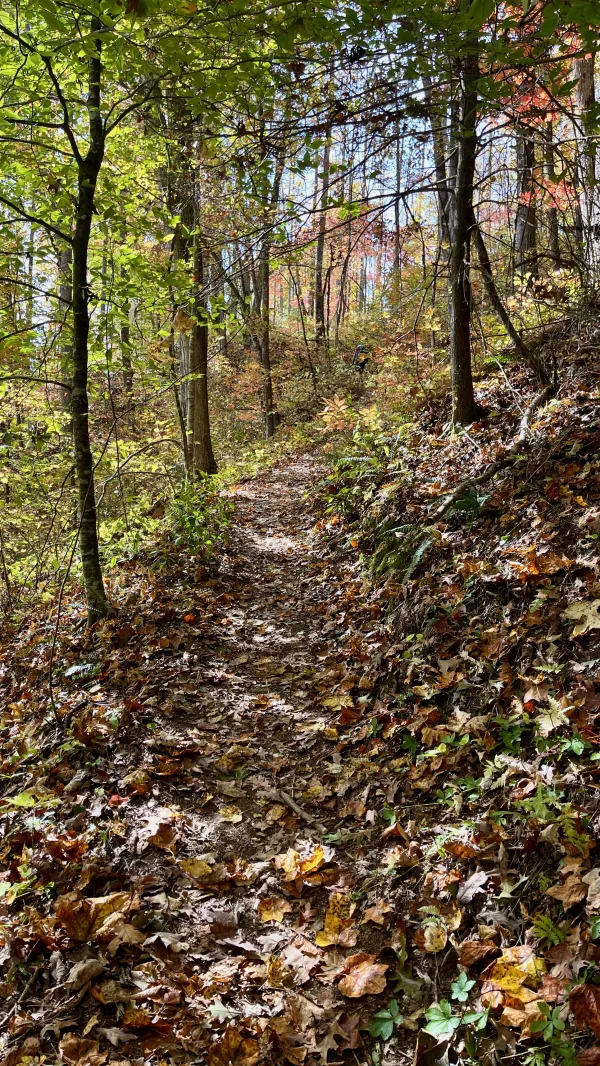
The trail doubled back to go along the tracks for a half-mile before we began our long climb to the top of Cheoah Bald.
Once the climb began, the route was sometimes extremely steep.

Thin clouds
The sun came out just as we began the climb. Although the sky was never clear, the sunshine was bright enough to raise the temperature, and I soon began to sweat.
Of course, the strenuous work of climbing with a 30-pound pack on my back contributed to that.

Ledbetter Creek
When I arrived at Ledbetter Creek at 1:20 p.m., I was ready for a break. I stopped to refill my water bottle and eat a snack.
I should have thought first to check where I was, though. I failed to notice I was only a quarter-mile from the campsite where Polecat and I had agreed to stop for lunch. He was waiting for me there when I continued up the trail.

Crossing Ledbetter Creek
We still had three miles to go before finishing the Bartram Trail at the top of Cheoah Bald. For much of the remaining distance, the climb wasn't as steep as the first mile.
Though I had just eaten a snack and lunch, I still felt tired. I couldn't seem to pick up my pace.

A section of trail with recent maintenance
The trail continued to follow Ledbetter Creek. In all, 2.6 miles of the climb went along the stream, which became narrower the farther we went up.
When I got near Bartram Falls, I noticed the trail was in better shape. It looked like some work was done recently. The footpath was wider and flatter, and water bars had been repaired to improve drainage.
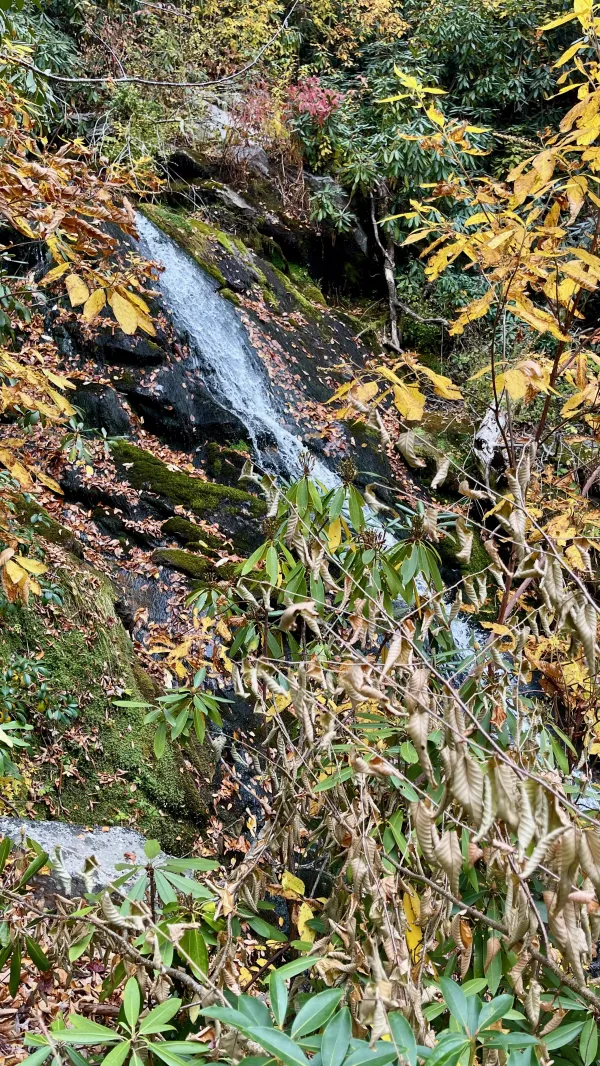
Bartram Falls
Bartram Falls was a small cascade that flowed next to the trail and was about halfway up the mountain. Though the waterfall is named in honor of William Bartram, historians assume he never made it up this mountain on his travels.
It's hard to say what route Bartram followed because his writings don't offer many details about it. Few written records survive about the area, and maps rarely existed at all. In his travels, Bartram had to rely on help from trappers and Native Americans.
The first white settlers didn't move into Western North Carolina until nearly a decade after Bartram completed his exploratory walk.

Crew members with the Southeast Conservation Corps
When I was past the falls, I came upon a maintenance crew working on the trail today. That explained why the improvements I saw below the falls looked new.
Eight workers were on the team, six crew members and two leaders. They told me they were part of the Southeast Conservation Corps, which is based in Chattanooga, Tennessee.
Like other trail crews I've met on hikes, the young people I talked to today were enthusiastic about their work. They told me they enjoyed being outdoors for days at a time. I could relate to that.

Tents used by crew members
After leaving the crew, I arrived at a road that ended at the trail. This was about three-quarters of a mile before the top. The maintenance crew had set up a camp on the trail and the road. Their tents were scattered across a wide area because there weren't many flat pieces of ground.

Gravity at the Bartram Trail's terminus
The last part of my climb was steep in short sections. Pushing to the top was tiresome, and I was relieved when I finally reached the junction with the Appalachian Trail at 4 p.m.
Polecat wasn't there, so I took a selfie before continuing.

A sign points the direction of landmarks on the AT
There was no way for my photo to show I was standing at the end of the Bartram Trail. The sign that marked the junction said nothing about that trail. It only listed the distances to landmarks in each direction on the AT.

A view from the top of Cheoah Bald
I didn't have much farther to go before cresting Cheoah Bald. Polecat was standing there when I arrived, enjoying the view.
Clouds were building again, and I wondered if we might get rain tonight. I had cell service at the top and could check the weather forecast. It said there was a 40 percent chance of rain tonight.
Tomorrow would be sunny for our descent down the mountain.

Polecat descends the AT to Sassafras Gap
Polecat and I had to go just over a mile down the mountain before reaching Sassafras Gap. The shelter was a short distance off the AT on a side trail.

Polecat checks out Sassafras Gap Shelter
No one was at the shelter when we arrived, which was to be expected for this time of year. There might have been weekend backpackers here last night, but it was too early for most SOBO thru-hikers to get this far south. Hikers going NOBO won't begin coming this way until mid-January.
Today was the fifth time I had been to Sassafras Gap. I slept in a tent near the shelter twice and inside the shelter once before.
Knowing rain might fall overnight, Polecat and I decided to sleep in the shelter. Tonight was the first time I slept in an AT shelter since Day 153 of my 2017 thru-hike. I generally prefer to sleep in my tent, but I remember that day was particularly exhausting, and I didn't have the energy to set up my tent.
Choosing to sleep in the shelter tonight turned out to be a good call. Light rain began to fall at 9 p.m. and became a downpour at 11:30.
The funny thing about tonight was that even though I had just finished hiking all of the Bartram Trail, my thoughts weren't on that trail. I was thinking about the AT. Staying at this shelter brought back a lot of memories.
In particular, I was nostalgic about the day I hiked up and over Cheoah Bald in 2017. I didn't stop at the shelter that day when I got to Sassafras Gap. It had been another difficult climb for me, but largely, it was difficult because I was putting pressure on myself to reach Fontana by the next afternoon.
Reflecting on that day reminded me how consequential my thru-hike turned out to be. I thought I was on a one-and-done adventure. There was no way of knowing what was yet to come.
We've been through some things together
With trunks of memories still to come
We found things to do in stormy weather
Long may you run
Long may you run, long may you run
Although these changes have come
With your chrome heart shining in the sun
Long may you run
This trail report was published