
Day 13 Jarrett Bald to Piercy Creek
More from this trailThere is trouble with the trees
I woke up this morning to the sound of scratching noises. If they came from an animal trying to get into my tent, I never saw the critter. There was also no damage in the netting or other parts of my tent, so I'm unsure what caused the sound.
It's possible the noise wasn't from an animal. It might have come from a low tree branch brushing against the side of my tent. When we stopped last night, we were unable to find a spot that had been previously used as a campsite, and we had to pitch our tents close to trees and shrubs.
Whatever made the sound, it woke me up a few minutes earlier than usual. Polecat and I were packed and ready to go sooner than most days.
Compared to yesterday's big climb to Wayah Bald, the trail today was going to be easy. We knew we had a long descent down to the Nantahala River, then the trail would follow the river upstream for several miles.
There weren't many camping options along the way, at least according to the GPS waypoints on my mapping app. One was about 14 miles away and labeled "Large camp site [sic] with creek access." That seemed like a good target for us.

Polecat walks on the Bartram Trail
The air was chilly when we started hiking, though not cold enough to make rhododendron leaves whither as they do in frigid temperatures.
The descent started right away. It was steep in several spots and leaves on the trail made the footing slippery. I fell once when my feet skidded out from under me.

The trail descends
The highest point of the trail we hiked yesterday was 5,385 feet at Wayah Bald. We camped last night at about 4,750 feet. The trail was taking us straight down this morning as quickly as possible, dropping in the next 2.1 miles to nearly 3,000 feet above sea level.

Wayah Road
That elevation was where the trail emptied onto Wayah Road, one of a small number of twisting mountain roads in this remote part of Western North Carolina. There were no houses on this road and only a couple of seasonal businesses catering to tourists who come here for the area's many recreational opportunities.

Nantahala Lake
The trail joined this road for a mile, briefly passing close to Nantahala Lake along the way. The lake was an impoundment of the river by an earth and rock fill dam owned by Duke Energy. The dam was constructed in 1942.

Closed businesses
I passed a small restaurant called Lakes End Cafe & Grill, which did not open until 11 a.m. A little farther up the road was a store and gas station. It was also closed and appeared to be shut down for good.
Around this time, a car stopped next to me in the middle of the road, and the couple inside rolled down the window. “Is there a store around here?” one of them asked.
"I think there may be a convenience store back the other way," I answered, pointing up the road in the direction they came.
"No, like a Sam's Club or Walmart," she replied.
I wanted to look around and ask, "Do you even know where you are?" Instead, I politely explained they would need to go to Franklin, which was about 45 minutes away. Without saying another word, they drove off.

The trail turns from Wayah Road
At 9:40 a.m., I arrived at the turn-off where the Bartram Trail left the paved road and continued on a dirt road. Polecat had stopped to wait for me there.
It didn't take him long to get ahead of me again because I stopped a couple of times to take photos.
An arrow scratched into the dirt
The trail followed a gravel road for about a half mile, then turned onto an unmaintained logging road.
Less than a half-mile farther, the trail left the logging road. Except for a yellow blaze mounted to a distant tree, there were no trail signs here to mark the turn. I might have missed it if Polecat hadn't scratched a large arrow into the dirt for me.
He later told me he missed that turn and walked past it before catching his error.

A concrete ford
I arrived at the Nantahala River about 45 minutes later. A concrete ford was there for vehicles to cross, but it was unnecessary at the moment. There was no water at the crossing.

A dry river bed
There were only a few puddles of water in the riverbed. All of the river's water was held back by the dam, which was a short distance away. Because of curves in the river, the dam couldn't be seen from where the trail crossed it.
The dam isn't the only method Duke Energy uses to control the Nantahala River's flow. There are also three small diversion dams, which are located at creeks that flow into the river. The result is a 9.3-mile-long stretch of the river where its flow is bypassed.

A road next to the river
There was a road on the other side of the river, and the trail followed it. I soon caught up to Polecat again, and we walked together along this road. We agreed to stop at Appletree Group Campground for lunch, which was a little more than two miles ahead on this easy section of the trail.

A penstock
A short distance before arriving at the road the led to the campground was a large pipe called a penstock. This was part of the diversion of water from the river to turbines for hydroelectric generation.
We followed the road into the campground, where we found a restroom with running water and a trash can. The campground was operated seasonally by the U.S. Forest Service. Groups of campers were there on two of the four sites.
After a short break to eat lunch, we deposited some trash and refilled water bottles before heading down the trail.

Leaving Appletree Group Campground
A side trail took us out out of the campground. We were accosted by a large dog as we passed the last group site. The dog's owner was lackadaisical about controlling the dog, so I stopped and waited. After a couple of bad experiences with dogs on trails, I've learned to make sure the dog's owner has taken charge before continuing forward.
After that short delay, we were back onto the Bartram Trail and following an old, gated Forest Service road.

The Nantahala River
The trail soon turned to follow a narrow, single-track trail that went along the Nantahala River. This part of the river had water, though it was narrow and shallow. Fisherman camps appeared at several spots on the other side of the river where there was also a gravel road.
We continued this way for the next hour before the trail made an abrupt turn and began to climb away from the river. We had now walked 10 miles for the day.

An overgrown section of trail
The next mile was a climb of about 500 feet. Along the way, I came upon a towel snagged on a tree branch. I guessed it had to have been Polecat's towel, so I shoved it into my pack to give to him when I saw him again.
Not much time passed before I caught up to him, and he confirmed the towel belonged to him. We walked the rest of the way together.

Polecat crosses a stream
When we arrived at Piercy Creek, the time was nearly 5 p.m. We didn't have far to go from there to our campsite, we just needed to cross a small feeder stream and then the creek. That should have been simple because neither stream was wide. Nevertheless, I slipped while crossing the creek and dipped the toes of one foot into the water.
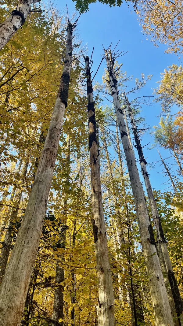
Tall, dead trees
At first glance, the campsite we selected did not look promising. Many of the tall, slender trees there were dead. We searched for several minutes to determine if we should continue down the trail or if we could find a spot where it was safe to camp.

A campsite on Piercy Creek
True to its description, it was a large site, and we eventually found spots for our tents where it seemed unlikely a tree would fall on us.
That wasn't the end of our trouble with trees, however. After dinner, Polecat's bear bag rope got tangled in a tree that was fallen near the one he was trying to use for a food hang. He had to spend several minutes climbing over and around the dead tree to retrieve his rope.
There is unrest in the forest
There is trouble with the trees
For the maples want more sunlight
And the oaks ignore their pleas
The trouble with the maples
(And they're quite convinced they're right)
They say the oaks are just too lofty
And they grab up all the light
But the oaks can't help their feelings
If they like the way they're made
And they wonder why the maples
Can't be happy in their shade
This trail report was published