
Day 7 Lemon Prong to Painter Branch
More from this trailPlease don't let me be misunderstood
When Polecat and I planned our hike of the Appalachian High Route, we wanted to make the distances between resupply stops as short as possible. We worked out a way to keep the distances four days or less.
Our next resupply stop will be at Standing Bear Hostel, less than three days after we left Hot Springs. We dropped off a box of food there before starting our hike.
When we made our hike plan, we thought we would stay tonight at Standing Bear. Our late start yesterday morning made that now unlikely, but it wasn't a problem. I knew of a campsite where we could stop if we didn't get to the hostel today. We will then have a short distance to go before picking up our food tomorrow morning.

The AT in the morning
Getting to the campsite required two big climbs totaling more than 4,800 feet, but Polecat and I didn't help ourselves get there. We were slow to wake up this morning and didn’t start hiking until well after 8:00.

red trillium
More wildflowers were blooming along the trail, particularly trillium. There are 43 types of trillium in the world, and 38 of those are in North America. I saw two varieties this morning. The first was red trillium, which had a deep crimson flower.

great white trillium
I didn't have to go far before seeing many great white trillium covering the side of a hill next to the trail. These were much more plentiful and showy, which are common traits of this variety.

A downed tree across the trail
In the area where Roaring Fork flowed next to the trail, I came upon a large blowdown, one of only two I saw today. This one was awkward to cross because it had many branches, though most had been broken to shorter lengths by previous hikers.
Many hikers passed me going northbound, the opposite direction I was headed. Nearly all were thru-hikers hoping to reach Maine. I'm sure they were enjoying today's gorgeous weather. Most of them would have entered the Smokies during the cold, rainy days we had a few days ago, and that's a difficult section to hike in bad weather.

Roaring Fork Shelter
I arrived at Roaring Fork Shelter shortly after 10 a.m. and took a short break. Like yesterday, I felt tired and unable to keep up with Polecat. Though I had trained for this hike and felt strong when I started, I wasn't feeling up to the climbs right now.
Was I not eating enough? Not sleeping well enough? Maybe I wasn't as strong as I used to be? I wasn't sure.
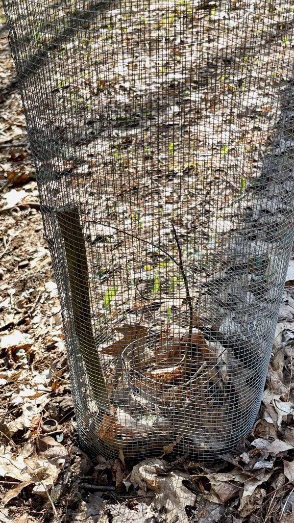
A chestnut seedling surrounded by chicken wire
The shelter was relatively new, constructed in 2005 to replace one that was too close to a road. Locals were using the old one as a party hangout on weekends.
While I was there, I checked out some plantings I had not seen when I was here before. They were blight-resistant chestnut trees, protected from wildlife with chicken wire.
A sign on the shelter said members of the Carolina Mountain Club planted the trees in honor of long-time trail builder and maintainer Howard McDonald. He was responsible for building the shelter and was the same person memorialized with a bronze plaque on Big Firescald Knob, which I passed on Day 4.

A green tunnel of rhododendrons
Leaving the shelter, the trail passed through one of the longest green tunnels of rhododendrons on the AT. I admittedly don't know this as fact, but it certainly seemed like it, based on my memory.
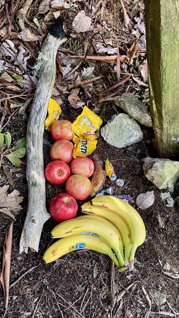
An example of irresponsible trail magic
On the other side of the tunnel was an old road and a gate. Some fruit and candy had been placed on the ground next to the gate. Although I'm sure thru-hikers appreciated finding this trail magic, I thought it was an irresponsible act by whoever put it there.
If an animal, particularly a bear, were to find this the food, it could become harmful. Bears lose their fear of humans when they find human food. When this happens, they become aggressive and dangerous, which makes them unpredictable.

A sign with a map showing a closure area
Just before the trail opened to the bald part of Max Patch, I saw a sign that wasn't there the last time I hiked this way. A map on the sign marked where camping and fires are prohibited. Groups larger than 10 are also not allowed.
The sign and the policies spelled out on it came after disastrous abuse was caused by visitors during the COVID-19 pandemic. People flocked to the bald, including several large groups, when they were unable to socialize in closed spaces. Unfortunately, they trashed the mountaintop.
Volunteers and U.S. Forest Service personnel cleaned up the mess, and the restrictions were put into place a short time later.

Climbing toward Max Patch
As I made my way up to the summit, I didn't see any signs of overuse. The trail and surrounding bald were in good shape. If the abuse left any scars, they were mostly healed by now.

A family enjoys the view from Max Patch
Families and other small groups of day hikers were at the top to enjoy the beautiful views and weather. It was a perfect day to be on Max Patch.
These conditions were far different compared to when I crossed the summit on my thru-hike in 2017. On that day, rain was blowing sideways. There were no views to enjoy, though even then, I appreciated being there.

Gravity and Polecat
I arrived at the top several minutes after Polecat, but he waited for me. We took a selfie because it was a beautiful time to be on the mountain.

Polecat begins the descent from the top of Max Patch
Leaving the summit, we could see across a range of mountains in Great Smoky Mountains National Park. We will enter the park tomorrow and begin walking across that range.

The trail is smooth on the descent from Max Patch
The descent from Max Patch was smooth and easy. Though Groundhog Creek Shelter would have been a good place to stop for lunch, we began to get hungry and decided to stop before getting there.
The shelter was nearly 85 years old and was recently improved by crews from the Carolina Mountain Club. They replaced the floor and brought in a food storage box because of problems with bears.

Approaching the top of Snowbird Mountain
The lunch stop was helpful because I got back some energy. Unfortunately, Polecat was now having trouble with plantar fasciitis.
The second big climb of the day was much steeper than the first, and I had less trouble with it. From Ground Hog Creek Shelter, the climb added 1,300 feet of elevation in three miles, leading to the top of Snowbird Mountain. An aviation beacon stood at the summit.
This section of the AT was another one I have hiked many times. It was a favorite for overnight backpacking trips when my sons were in the Boy Scouts.

An AT trail marker
We reached the summit at 5:30 p.m. and stopped briefly to enjoy the view.
On the way down from the top, we passed an unusual trail marker. It was a three-dimensional version of the familiar stacked "A" and "T".

A campsite near Painter Branch
After a sometimes steep descent, we found the campsite I had in mind, arriving there at about 6:30 p.m. I had never camped at this site but remembered seeing it on previous hikes. It was a wide and flat spot near Painter Branch. After setting up our tents, Polecat and I soaked our feet in the cold stream.
Some thru-hikers heading up Snowbird Mountain mistakenly entered the campsite. They thought the trail crossed the stream instead of staying to the left. We redirected them back to the stream crossing to find the trail.
Later, while I was in bed and finishing notes for my blog, I saw light from a hiker's headlamp. I presumed this person was looking for a place to camp, so I called out, "There’s lots of room!"
A female giggled at that, apparently taking my comment as an invitation into my tent.
Embarrassed, I quickly answered, "I mean for your tent!"
The hiker then asked if she was off the trail. I confirmed that she was, telling her to go back the way she came and look for the trail on the other side of the stream.
Baby, you understand me now?
If sometimes you see that I'm mad
Don'tcha know that no one alive can always be an angel?
When everything goes wrong, you see some bad
But oh, I'm just a soul whose intentions are good
Oh Lord, please don't let me be misunderstood
This trail report was published