
Day 171 Sierra Buttes Spring to Mule Ears Creek
More from this trailRunnin' down a dream that never would come to me
When I was thru-hiking the Appalachian Trail, I often repeated a popular expression, "Maine isn’t going to walk to me."
Sure, it was said as a joke. As with any adage, though, there was a general truth to it. A goal won't come to you. You have to work to earn it.
I don't think "Truckee isn’t going to walk to me" works quite as well, even if the same sentiment is true. I never expected my hike would end there. Weather and trail friendships shaped the route I took, however. Truckee is where I will finish, and I'm just as satisfied with that as I would be finishing at a border.
And that will happen tomorrow.

Dusk on the PCT
I left camp at 6:40 this morning. Even though that was about 45 minutes before sunup, there was more light in the sky than usual for this pre-dawn time. I think this was because of the smoke in the air. It diffused the light coming from the sun, which was still well below the horizon.

Above the valley
From Sierra Buttes Spring, the trail made a 7.5-mile descent. The trail dropped 2,800 feet into a deep valley.
The small town of Sierra City was at the bottom of the valley. For a long time until sunlight finally reached the bottom, I could see lights shining in homes and the town's few businesses. Occasionally, a car would drive along the main road that went up the valley.
There wasn't much activity to see, though. Sierra City isn't large, with a population of 221 people, according to the 2010 census.

Sunrise on the PCT
In the minutes before the sun rose above the horizon, the sky turned a deeper pink as more of the sun's early rays filtered through the smokey haze.
The wind was blowing hard, just as it did yesterday. When I walked past the other spot where I had thought about camping last night, I was glad I had thought better of it. There was no protection here from the wind.
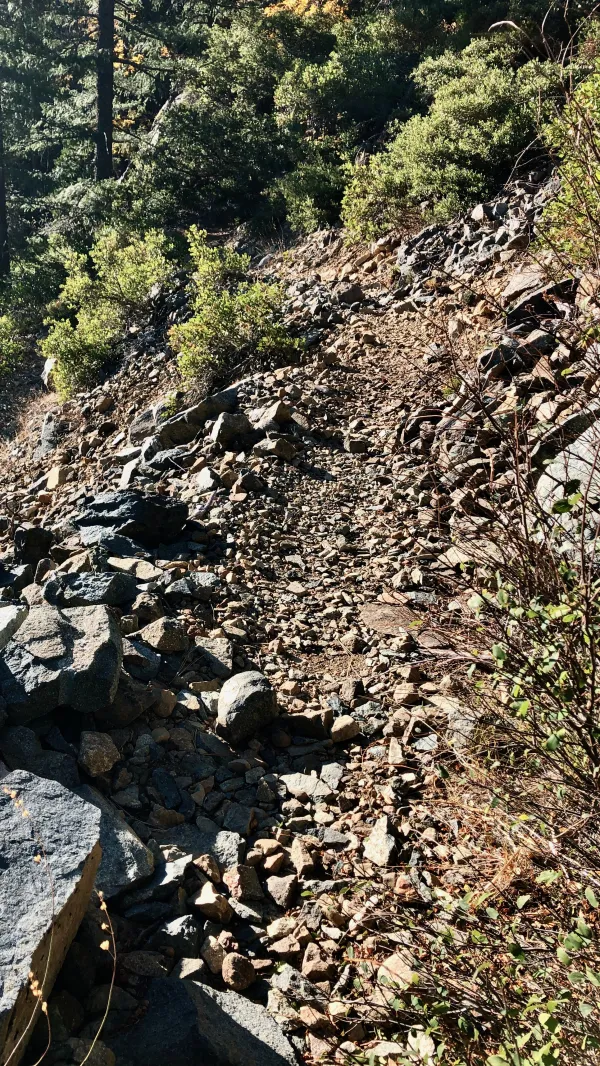
Descending a rocky trail
The descent was easy, even if it wasn't smooth. For much of the way, the footpath was covered in small rocks. These were the kind that typically gives me the most trouble, but I walked quickly and didn't twist an ankle.
It helped that my pack was light. I was only carrying enough food to get me through tomorrow, and it wasn't necessary to haul a lot of water.

Green and yellow
The final four miles to the bottom of the valley would have been much steeper if not for several switchbacks. In the last couple of miles, the trail went through a thick forest. The leaves on the trees were at their peak fall colors.
At the bottom, the trail crossed California Highway 49. That was the route I would have taken to get to Sierra City if I still needed to resupply.
Thanks to my unexpected stop in Belden four days ago, that wasn't necessary.

Footbridge over the North Yuba River
On the other side of the highway was the North Yuba River. It ran through the middle of the valley, as did the road. A substantial footbridge crossed the river, which was needed because the water was dangerously swift.
The river is a popular fly-fishing destination. Sierra City started as a mining town and remains viable thanks to tourism and outdoor recreation.

View of Haypress Creek
After crossing the river, the trail entered another deep valley. This one was formed by Haypress Creek. For the next two miles, the trail descended into this valley before it reached the creek.

Haypress Creek
I arrived at the creek at 11 a.m. It was pretty, especially with the trees in their fall colors.
As soon as I crossed the footbridge over the creek, the trail began the first substantial climb of the day. It now went up a canyon formed by Milton Creek, which flowed into Haypress Creek just below the bridge.

The trail with overgrown shrubs
After stopping for lunch at noon, I continued up the climb. From the footbridge, the ascent went up 1,800 feet in five miles. Along the way, the trail crossed Milton Creek twice.
The trail used several switchbacks to take me to the top of a ridge.
Some spots in the upper elevation of this section were similar to many of yesterday's high points. There were large boulders and fewer trees. Overall, though, there weren't as many open spaces and views as yesterday.
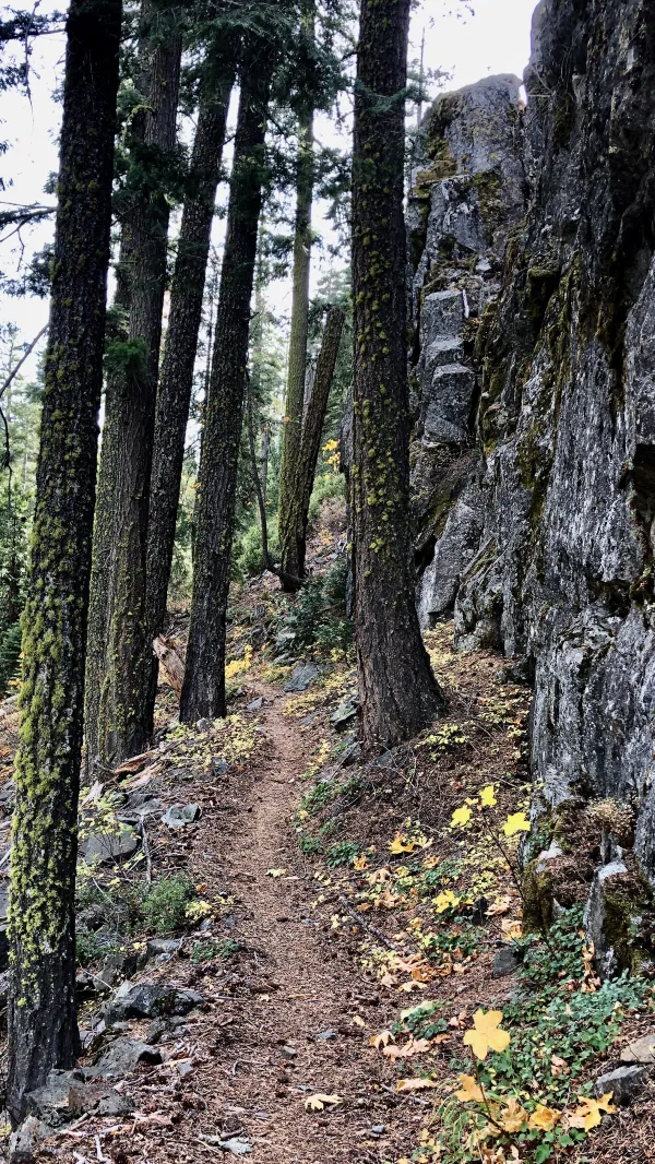
The trail next to a rock wall
The trail also passed a rock wall, which reminded me of many trails in the east.
The sky gradually became cloudier. These were wispy, high clouds, however. I didn't worry about the chance of rain for the rest of my hike.
At the end of the climb, the trail made a series of ups and downs. Along the way, it crossed some forest roads.
Much the same as the day before yesterday when there were several roads near the trail, I came upon some mountain bikers. I reminded them that bicycles were not allowed on this trail.
The riders didn't try to pretend they didn't know they were on the PCT. They claimed they only rode on the trail in October, as if that made it okay.

A view of Jackson Meadows Reservoir
In the up-and-down section along the ridge, Jackson Meadows Reservoir came into view. It was created when an earthen dam was constructed in 1965 on the Middle Fork of the Yuba River.
Several campsites maintained by the local water utility circle the 1.5 square miles of the lake. They make the lake a popular place for fishing, swimming, boating, and water skiing, but I didn't see any of that activity today.

Volcanic rock on a ridge
Near the end of the day, I walked along another high ridge. This one climbed to 7,300 feet and was littered with large volcanic boulders. The views were enjoyable from here, but I was more fascinated by the dark basalt rocks, which were oddly shaped.

Gravity's last campsite on the PCT
I arrived at my campsite at 5:50 p.m., about 45 minutes sooner than I had calculated. With the extra daylight, I could have gone two more miles to another campsite, but there was no water source there.
I collected water first so that I could take care of that chore while I still had daylight. The creek was a shallow stream that was a little difficult to locate. I found the creek after hunting for it in a large cluster of mules ear plants, which wasn't surprising, considering its name.
Except for the mountain bikers, I saw no one on the trail today. Once again, I had the campsite to myself. Unlike last night, this site was roomy and flat.

The last sunset
My last night on the PCT ended with one of the best sunsets of my hike. It was a fitting ending.
Shortly before I was scheduled to start my Appalachian Trail thru-hike, I learned I would need a hernia repair operation. During the time I was uncertain about the length of my recovery, I considered switching my plans and hike the PCT. I didn't want to start the AT too late when the weather got hot and muggy.
My recovery time turned out to be shorter than I expected, so I resumed my plans to hike the AT. And as I've written before, when I finished, I didn't think I ever wanted to hike another long-distance trail.
Somehow, in a round-about way, the PCT became a thru-hike dream. It was unexpected, but I'm grateful for it. And tomorrow, it will come true.
I rolled on as the sky grew dark
I put my pedal down to make some time
There's something good a-waitin' down this road
I'm pickin' up whatever's mine
Yeah, runnin' down a dream
That never would come to me
Workin' on a mystery
Goin' wherever it leads
I'm runnin' down a dream
This trail report was published