
Day 72 Willow Creek to Grand Lake
More from this trailYou must be the angel I thought I might never find
OldTimer, Top O', and I had successfully answered some of yesterday's unknowns, but we weren't done with them. We still had more than 20 miles to go before reaching Grand Lake. We also needed to resupply and rejoin the trail. Uncertainty remained about where and how this would happen.
One of the unknowns was in finishing our route across national forest land and into town. According to walking directions provided by Google Maps, it appeared we could take a shortcut to the highway leading into town. Those directions were a little murky, but for now, we were counting on them.
We also didn't know where we would stay tonight, though there were a couple of options in Grand Lake we could check once we got in range of a cell signal.
Finally, there was still the matter of walking on land the National Forest Service had closed because of last fall's East Troublesome Fire. I wasn't feeling unsafe doing that, though I was still uncomfortable about violating the closure order. The possibility of being fined, arrested, or even just firmly scolded if we were caught was still in the back of my mind.
We had a dozen ways to rationalize why we were walking in the closed area, but none would matter if a forest ranger decided to enforce the closure. All we could do was keep walking and try not to attract any attention before we got out of here.

A forest road through burnt trees
Under a pasty morning sky, the surrounding terrain looked bleaker than yesterday. Nearly everything I saw was black, brown, or grey.
The clouds may have cast a dreary light, but they kept the air cool. With that and a smooth gravel road to walk, we hoped to make good time and arrive at Grand Lake in the late afternoon. We also left our campsite before 6:30 a.m. to give ourselves extra time.

monument plants
There may not have been any sun, but one field was brightened by a large patch of monument plants. Many stood more than three feet tall and all were in full bloom.
They are sometimes called elkweed or deer's ears. Elk and livestock like to feed on them.

monument plant
Monument plants have an unusual growth pattern. They grow for several years without blooming, then die shortly after they flower. They prefer to grow on moist mountain meadows and slopes.
This was the first time I had seen monument plants, though maybe that's because of the way they flower.

A bridge destroyed by fire
Although the dirt road we followed wasn't in bad shape, we had to cross three wooden bridges badly burned in last October's fire. None were sturdy enough now to support a vehicle, and one was almost burned away.
This wasn't a problem for us because the streams they crossed weren't deep. However, they certainly would have been a reason why the roads in this forest were closed.

A green field surrounded by burnt trees
I thought at first the sky was beginning to brighten a little until I realized it was the ground that brightened. New grass was taking over a field ringed by dead trees.
Despite the intensity of the fire that swept through this mountain valley, nature was already finding ways to restore the land.

Top O' and OldTimer
We thought we saw Sunshine yesterday walking far ahead of us, but we didn't see him today. We wondered if maybe he found a different route, or worse, had gone the wrong way.
Admittedly, we weren't entirely convinced we were going in the correct direction. Our navigation resources were limited, and what appeared on the maps didn't always match the features on the ground. We combined and compared what we had, and made guesses at other times.
Guthook wasn't any help now because we were too far from the CDT. Google Maps showed roads and streams but little else. The Ley maps I had on my phone offered the best views of topography and landmarks, but we would soon be out of their coverage area.

A bleak, burned forest
Our campsite last night was at 9,250 feet in elevation. The road we followed this morning climbed to 10,600 feet in the first 5.7 miles. Because we were walking on a road, there was never a steep section.

The road begins to descend
When the road began to descend, we had a smooth glide down for the next 7.3 miles, dropping all of the previous elevation gains and then some.
Top O' had been sometimes slower than me on previous road walks, but today he was much faster. OT and I lost track of him by mid-morning. That was a little bit of a concern because I was the only one navigating. At least for now, however, there was just a single road to follow and no place to turn in the wrong direction.

A view of Granby Lake
The main body of Lake Granby came into view shortly before 11:30 a.m. It was about five miles away, but we weren't heading directly that way. Before long, the Forest Service road would turn from a mostly southbound direction to going mostly east. Then we would look for the Google Maps shortcut to U.S. Highway 34 and go north to Grand Lake.
As I came to a bend in the road, OT slowed down and turned to me.
"Busted," he whispered, pointing ahead to a National Forest Service truck.
There wasn't any place for us to go and avoid being seen, so we just kept walking. I looked around to see if Top O' was nearby. He wasn't, and I took that as a good sign. At least he wasn't standing next to the truck in handcuffs.
Looking past the truck, I saw a forest ranger talking on a cell phone. I nodded and nonchalantly walked past. Then I saw another forest service employee a few yards away. He was also on a phone. Neither one paid any attention to us. They appeared to be on a conference call, and it was clear they weren't bothered by us walking by.
Our concerns about getting caught while walking on the closed road turned out to be nothing.

A large field with tents
The sun began to break through the clouds around noon, and the temperature became much warmer.
As OT and I approached the end of the Forest Service road, I noticed several tents were set up in a field. Soon, I discovered why they were there when I saw some vans parked along the road. Crews from a not-for-profit organization called Rocky Mountain Youth Corps were here to work on clearing downed trees and repairing damage from last fall's fire.
About 150 young people are hired each year by RMYC to work on residential and environmental conservation projects and outdoor education in northwest Colorado. There was certainly a lot of work available for them to do here.
OT and I stopped for a lunch break just past Idleglen Trailhead. We still hadn't seen Top O', but we were hungry and needed a break.
Soon after we finished eating and continued walking, we found Top O' where he had stopped for lunch at Stillwater Pass. He told us he found in Guthook a phone number of a trail angel living in Grand Lake. Her name was Karen Hester, and she used the trail name Cairn. The comment that listed her number said she hosts hikers at her home.
When Top O' called her, Cairn quickly agreed to let the three of us camp in her yard. We could shower and do laundry there, plus she would feed us. All she asked was that we buy a dozen eggs at the grocery store on our way to her house.
This could not have been better news because it solved the problem of where we were going to stay tonight.
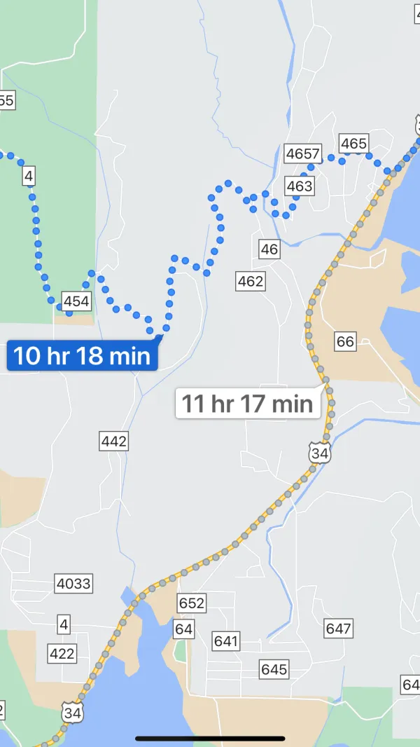
Google map
The shortcut Google Maps found for me yesterday would shave an hour of walking. When I found this route while on Parkview Mountain, I made a screen capture in case I didn't have cell service later when we needed to look for the shortcut.

Walking the wrong way
Top O' had sufficient cell service to call Cairn, but it wasn't strong enough at Stillwater Pass to receive data needed by Google Maps. I pulled up the screen capture on my phone, and we set off to look for the shortcut.

A closed, private road
As I said, there were some limitations and discrepancies in what Google showed compared to the ground. That became especially apparent as we attempted to find the shortcut. Worse still, my screenshot was now the only navigation aid we had. We were out of range of my Ley maps and Guthook.
Before long, we discovered Google's route went down a private road. It was so private, in fact, that it was blocked by a warning sign from the local sheriff's department and barbed wire.
We may have been able to walk on a closed Forest Service road without any consequences, but we weren't about to attempt the same thing here on a private road. We turned around and walked back to Stillwater Pass and take the long way to Grand Lake.

Walking on U.S. Highway 34
We had already walked 18 miles when we reached U.S. Highway 34 at 2:45 p.m., but we still had nearly six more to go before getting to Grand Lake.
The sky turned cloudy again, yet the heat didn't go away. I was tired and thirsty by now. For the whole distance to Grand Lake, I hoped to find a gas station or vending machine to buy a cold drink. There were none until we reached the grocery store near Cairn's house.
We all bought drinks, and Top O' remembered to buy Cairn's eggs. While we were cooling down outside the store, some out-of-state tourists walked up to us. They said they had seen us earlier on the highway and wondered what we were doing. "Walking to Canada" was not the answer they expected.

On the road to Cairn's house
Cairn’s house wasn't far from the store, but it required walking up a steep road. This was the first steep climb of the day, and by now, I was dragging behind.
One of Cairn's neighbors said cheerfully, “You’re almost there!” A short distance farther, a woman walking her dog said, “The nice house is just around the corner.” These comments hinted that we were about to have a wonderful trail angel experience.

Cairn is grilling
Cairn greeted us warmly, showed us where to find the bathroom and washing machine, and offered us beers while we relaxed on her porch. Later, she grilled elk burgers, elk sausage, pork sausage, and a variety of vegetables. We had ice cream for dessert.
As we talked, I found Cairn was not only sincere in wanting to help hikers like us, this was how she was every day for everyone. She was active and committed to the pursuit of social justice. Now I understood why her neighbors were so enthusiastic as we walked to her house.

Cache 22
After we finished the delicious feast, a hiker named Cache 22 arrived. He camped in Cairn's yard last night, and though he was staying at a hostel tonight, he still wanted to come by and hang out.
While we talked, we realized Cache 22 wasn't just a thru-hiker. He was an extraordinary trail angel in his own right. He maintains a vital water cache on the PCT near Old Station, also named Cache 22. Bluejay and I camped there on Day 161 near the end of my 2019 thru-hike.
We set up our tents in Cairn's yard shortly before a light rain began to fall. This was the first time it had rained on us since Top O' and I left Colorado three weeks ago to start our flip.
I've often repeated the common trail saying, "The trail provides." Examples of that are found day after day. Today was different, though. It was a special day, the likes of which have happened just a few times on my other hikes. The conventional wisdom about the CDT is there aren't many trail angels, so today was unexpected.
The trail didn't only provide what I needed today. I was given unconditional kindness and generosity by a stranger who is now a friend. It was an astonishing and endearing gift.
This must be heaven
Tonight I crossed the line
You must be the angel
I thought I might never find
Was it you I heard singing
Oh while I was chasing dreams
Driven by the wind
Like the dust that blows around
And the rain fallin' down
This trail report was published