Day 73 Grand Lake to Twin Creek
More from this trailEvery day you see one more card
As of yesterday, I have walked more than 1,000 miles of the Continental Divide Trail. It's a nice milestone to pass, even if many more miles than that are still to go.
When I thought about this, I tried to compare the CDT with my other hikes at the same mileage. I passed 1,000 miles on Day 72 of the CDT. When I was hiking the PCT in 2019, I had gone that far by Day 74. I passed 1,000 miles on the AT in 2017 on Day 76.
Comparing those hikes in that context is a little strained, though. By the time I reached 1,000 miles during the first two hikes, I had already taken a long break in each one. I didn't count those as days on the trail. I took a week-long break while on the AT so I could go to a conference in Baltimore. I left the PCT for 44 days to give snow time to melt, then flipped to hike south from the Canadian border.
Although I took a break on this hike, which was when Top O' and I flipped to Wyoming. I counted those six days as zero days and justified that because I didn't go home.
In other words, if I subtracted those six days to make the comparison more similar, I would have hiked the CDT's first 1,000 miles much faster. The average would be about two miles more per day. And of course, that makes sense. I'm hiking now with the experience and conditioning I gained from my previous hikes.

Gravity, OldTImer, Cairn, and Top O'
Rain fell last night for about two hours. I realized this morning when I woke up that I hadn’t been careful where I positioned the groundsheet under my tent when I set it up last night. Rain collected on it, and some leaked into my tent floor. My quilt was wet on one corner, so Cairn let me put it in her dryer.
Cairn said breakfast would be ready at 7:30 a.m., and that gave us a little extra time to sleep in, then leisurely pack our gear.
As we ate breakfast, Top O', OldTimer, and I realized we had some planning to do. There were many resupply options ahead, so it seemed wise to plan now for how to handle them. I worked on some ideas after breakfast while OT and Top O' unboxed and installed a new TV Cairn had just bought.
I had stayed in touch with Sasquatch since I last saw him on Day 40. He said he might be able to help us resupply when we reached Interstate 70, so I reached out to him today. He told me he was hiking on the Centennial Trail in South Dakota. Based on our schedule, he didn't think he would be back in time to meet us.
That was one reason I wanted to figure out a resupply plan now. Another was to decide when to replace my shoes. The best solution I could find was to order a pair and have it held for me at the REI store in Dillon. I should be able to pick them up in about ten days.
Now that I had figured out how many days we would have between our next few resupply stops, I was able to text Kim and let her know when I need a box sent to me. I asked her to send one to Monarch Pass. We won't get there for more than two weeks, but I wanted to make sure she had plenty of time to prepare the box and mail it.
When OT and Top O' were finished hooking up Cairn's TV, we said goodbye to her. She had been a wonderful trail angel, and we could not thank her enough for her generosity and kindness.

Walking toward the center of Grand Lake
The sky was thick with clouds as we left Cairn's house at 10:30 a.m. We couldn't tell if more rain was on the way, though it seemed likely.

Repackaging food outside the grocery store
We returned to the same grocery store we stopped at yesterday. It took us about 45 minutes to shop, then repackage our food.
The CDT went through the town of Grand Lake, so we didn't have far to go to get back on it. On the way, we passed a restaurant with outdoor seating and decided to stop there for lunch.

Leaving Grand Lake on the CDT
After a leisurely lunch, we didn't get back on the trail until nearly 1 p.m. We were finally reconnected with it after walking an alternate around the fire closure the last two days.
Our route today was flat for nearly the whole way. Most of the time, it went along the shoreline of a lake or river.

Rain clouds over Grand Lake
Dark clouds loomed over mountains to the east of Grand Lake, and rain appeared to be falling. That was in the direction of Rocky Mountain National Park, which abutted the lake and town.
Grand Lake is Colorado's largest natural body of water. It was formed by glaciers and is the source of the Colorado River.
The town at its shore has been a tourist destination since the mid-1800s when European hunting parties camped here. Summer cottages began to be constructed soon after that, and by 1867, the town was started. Then and now, only a few residents live here year-round.

Rain on the other side of Shadow Mountain Lake
Rain could also be seen falling to the west, on the other side of Shadow Mountain Lake. Rain falling on us was starting to seem more likely. We weren't heading to a high elevation today, however, so we weren't concerned about the possibility of lightning.
The mountains are the reason for the rainfall and the lakes. Because the mountains are high and run north-south where the prevailing winds are westerly, this side receives a lot of rainfall and snow. The east side of the mountains does not.
Unlike Grand Lake, Shadow Mountain Lake and Lake Granby to the south are man-made. They were created during a major reclamation project started in the 1930s and 1940s called the Colorado–Big Thompson Project. It includes 11 reservoirs. A tunnel extending under the mountains from Grand Lake's eastern shore pipes water to the arid east side of the Rockies.

Top O' walks along the CDT
The trail left the town where it crossed a bridge over a narrow channel between Grand Lake and Shadow Mountain Lake. We were now entering Arapaho National Recreation Area, which surrounds most of the two man-made lakes.
Like so many parts of Colorado, the tall lodgepole pine trees here had been severely impacted by the pine beetle infestation.

Entering Rocky Mountain National Park
After walking for about 45 minutes, we left the recreation area and entered Rocky Mountain National Park. This was one of two sections of the park the trail crossed. The other section was where we had to detour because of the fire closure.
Bear canisters and a permit are required when camping within the park, and the park is the only place on the CDT where canisters are required. Only 5.5 miles of the trail we were on today went through the park, so the canister requirement wasn't a concern for us. We knew we would be well outside the boundary before we wanted to stop for the night.

Walking along the lake
The trail didn't always stay next to the shoreline. At times, it climbed to follow a slope of Shadow Mountain.
We met a section hiker named Birdseed along the way. He told us a little about the trail ahead, and we told him about the fire closure. We tried to describe the alternate route we created, but I'm not sure how much he understood. Admittedly, it was a complicated way to go if you don't have a map.
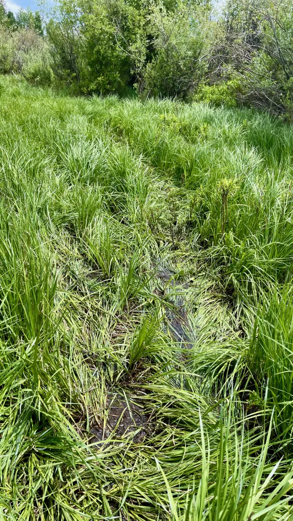
Swampy trail
Past the slope of Shadow Mountain, the trail crossed a long section of tall grass. It was saturated with water in many places. There was no way to avoid getting my shoes wet, and I had to just slog through it.
The tall grass made it difficult a couple of times to find the trail, though I never strayed far from it.

shrubby cinquefoil
The grassy section was open and exposed to full sun, so there were also many wildflowers here. Among them were shrubby cinquefoil. A cultivated variety of this plant is called potentilla.

Top O' stops to look at the Colorado River
While still within the national park, the trail reconnected with water, which was now the Colorado River. It flows for 1,450 miles through the Grand Canyon and across Arizona before entering Mexico and flowing into the Gulf of California.
The dams and tunnel of the Colorado-Big Thompson Project aren't the only major reclamation operations siphoning water from the river. Aqueducts, dams, and reservoirs divert water along its entire length to supply farms and cities.
The river is often completely dry where it empties into the Gulf of California. The southwest has suffered several long droughts during the last 60 years, and planners failed to fully calculate the impact of those conditions when they designed the projects.

The Colorado River
The river gradually widened as we continued walking south along its east bank. We were following it downstream toward Lake Granby.

columbine
The trail along the river had more trees than along the lake, and plenty of damage was also done here by pine beetles.
I found a lot of columbine growing on the trail.

Threatening sky
The trail left the national park near an open field, and this gave me a better view of the sky. It was still dark and threatening. So far, though, not a drop of rain had fallen on us.
We were four-tenths of a mile past the boundary when we stopped at Twin Creek to collect and filter water. The creek looked like a better spot to get it than the river.
By now, the time was 5:30 p.m. Though we saw a good spot to camp near the creek, we decided we wanted to add a couple more miles to the day before stopping.

Roger That talks to OldTimer and Top O'
We didn't get far before meeting Roger That. We hadn't seen him in several weeks, and it was fun to catch up with him. He was going northbound and had already gone through all of Colorado.
Roger That told us we wouldn't find any place to camp for several miles. Learning that, we decided our best option was to backtrack to the campsite we just passed.
Roger That knew the story behind my trail name. “Stay upright, Gravity!” he cautioned as he left.

Eating dinner
The campsite near Twin Creek was within sight of the river. There was plenty of room for our tents, plus a large fire ring. This appeared to be a popular spot for boaters and hunters to camp, though we were the only people there tonight.
The sky began to rumble when we arrived, so we quickly set up our tents. No rain fell, however, until we were finished with dinner and were starting to pack away our cook gear.
The rain fell in a light sprinkle at first. A storm of heavy rain and wind arrived at 8 p.m.
It's funny for me to think now, more than 1,000 miles into this hike, how resistant I was initially about thru-hiking the CDT. In these first two-and-a-half months, the trail has revealed a little more of itself each day. And in that time, I have grown to appreciate it more. These days have strengthened my will to finish it.
I'm grateful now that I let down my initial reluctance to hike the CDT. We'll see if I feel the same way after another 1,000 miles.
Oh baby, don't it feel like heaven right now
Don't it feel like somethin' from a dream
Yeah, I've never known nothing quite like this
Don't it feel like tonight might never be again
Baby, we know better than to try and pretend
Baby, no one could have ever told me 'bout this, yeah, yeah, yeah yeah, yeah, yeah, yeah yeah
The waiting is the hardest part
Every day you see one more card
You take it on faith, you take it to the heart
The waiting is the hardest part
This trail report was published