
Day 104 Lake 10839 to Shadow Lake
More from this trailWhen will I see you again?
If thru-hiking were classified as a chronic and incurable condition, its root cause for me could be traced to when I first joined the Boy Scouts at age 11. I wrote about that consequential experience here.
The events that cemented my need to spend extended time outdoors started in my mid-40s and also through Scouting. My sons joined a troop that focused on high-adventure outings. Instead of spending a week at a local district's camp each summer, the troop would make trips to far more venturesome locations.
As an assistant scoutmaster, I made as many of these trips as I could, and continued going on them after my sons earned their Eagle ranks and left for college. One of the trips I made with my sons was to Mt. Zirkel Wilderness in 2002, which I described when I passed through there again on Day 65 of this hike.

Gravity in Wind River Range, 2010
Of all those scouting trips, the one that made the biggest impression on me was a trip to Wind River Range in 2010. My friend Ralph (Polecat), was also an assistant scoutmaster and was with me on that trip. After hiking into the wilderness area from Big Sandy Trailhead, we led our crew north.
I remember being awestruck as we reached the top of Jackass Pass and looked down into the Cirque of the Towers. The granite spires and surrounding valley were mesmerizing.
Before we left this otherworldly place, I was already saying to myself, "I need to get back here someday."

The top of Temple Peak is orange because on a sun effect called alpenglow
Finally today, I was heading back to the cirque. I couldn't wait to see the same views that made such an impression on me.
Everyone who camped last night at Lake 10839 was prepared to leave at about the same time. By 6:30 a.m., we were on our way up the steep route over Temple Pass.
The cirque where we camped was still in the shadows of surrounding mountains. Alpenglow illuminated Temple Peak in brilliant orange.

Climbing to Temple Pass
The route up wasn't always easy to find. The footpath was sometimes indistinct. Although everyone either started ahead of me or soon passed me, I felt I made good time up the 700-foot climb.
I was glad I didn't have to make the climb yesterday evening and was surprised that Tokyo did.

Nearing the top of Temple Pass
With his long legs and a head start, Top O' reached the top well before I did. I didn't see him again for the next three hours.
I followed Fire Hazard and her friend as the last of our group.

Looking back from Temple Pass
It took me 35 minutes to make the .9-mile climb to the top of the pass, which was slower than my normal hiking pace but not by a lot.
Approaching the top, I looked back as I always like to do to see where I had come from. Lake 10839 was still in shadows. I got a better view of the large swath carved by an ancient glacier, as well as the cirque. That is where the glacier ended its grinding crawl through these mountains.
It surprised me to learn that Bridger Wilderness, which covers much of Wind River Range, is where seven of the ten largest glaciers in the world can be found. That helps to explain why there are other cirques like where we camped and Cirque of the Towers.
The glaciers also explain why there are more than 2,300 lakes and ponds in the region.

At the top of Temple Pass
Crossing the top of Temple Pass wasn't as easy as most I have hiked over. They're usually narrow. This one was broad and covered in large boulders. We had to step on or hop across them to get to the other side.

Gravity at Temple Pass
Before starting down from the top, I offered to take a photo of Fire Hazard and her friend. She then took one of me.

Looking north from Temple Pass
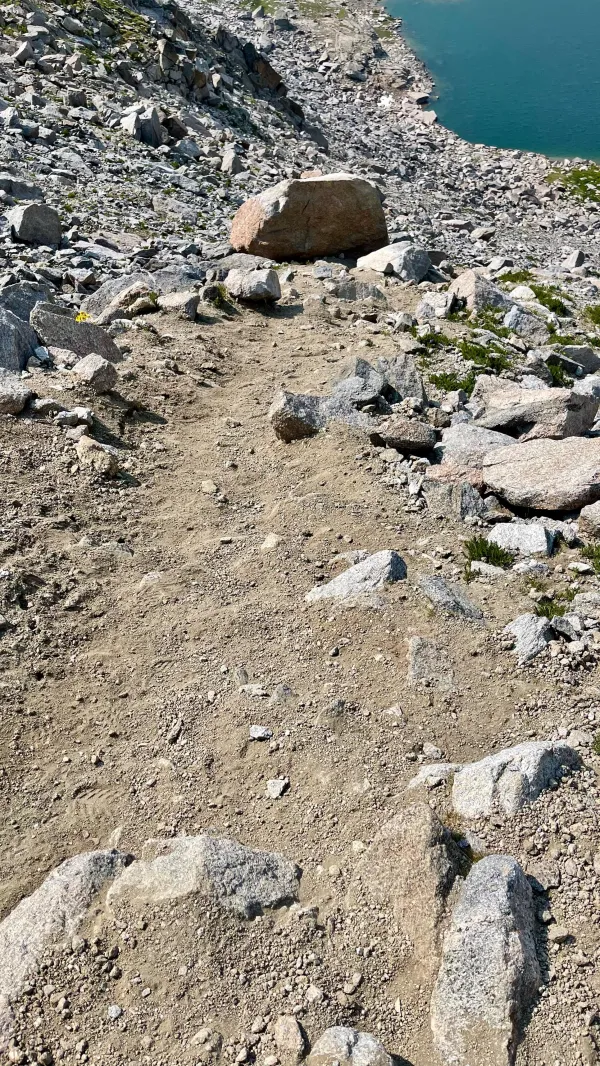
There was a surprising amount of water near the top on the other side. The trail followed this stream down to Temple Lake, making a sharp drop of 850 feet in less than a mile. Loose sand and rocks made the descent treacherous, and of course, I took my time going down.

Temple Lake
Fire Hazard, her friend, and everyone else was long gone by the time I reached the lake at the bottom of the descent.

Yellow and white columbine flowers
The next few miles were easy and enjoyable. I didn't walk any of the trails in this section south of Big Sandy Lake when I was here 11 years ago, so the scenery was new to me.
Along the way, I saw some of the most beautiful columbine flowers I've ever seen in the backcountry. There are dozens of varieties of this flower, but to truly see them in their native state, you must come to someplace in a high elevation like this trail.

Looking back at East Temple and Temple peaks
The trail to Big Sandy Lake mostly descended along Rapid Creek, with only a couple of short climbs away from the creek.
Before it got out of sight, I looked back toward Temple Pass one last time. I could not only see the pass and Temple Peak, but I also now saw East Temple Peak. It wasn't visible from the other side of the pass.

Rapid Creek near Big Sandy Lake
When I got close to where Rapid Creek flowed into Big Sandy Lake, I stopped to collect and filter some water from the stream. While there, I spotted Top O' making a turn around the other side of the lake. I was glad to know I hadn’t lost much time behind him.

Big Sandy Lake and Schiestler Peak
I followed the trail around the east side of the lake. This was a trail crossroads, and I expected to see backpackers going in every direction. There were some but not nearly as many as I thought there would be.
A large field of wildflowers filled my view of the lake, with Schiestler Peak standing behind it. That mountain was on the same ridge as Temple Peak.
This area was familiar to me. I remembered having difficulty in 2010 on the climb that started after the lake. Adjusting to the altitude was hard for me, and I quickly became winded.

domesticated goats on the trail
There was one sight on the climb I didn't see 11 years ago. I unquestionably would have remembered it if I had seen domesticated goats. A family from Arizona was hiking with them. The goats had hiked in with packs to carry some of the family's camping gear.
The family had set out today on a day hike from their base camp. The goats had to go with them, a family member said, because their permit didn't allow them to keep the goats penned unattended at the base camp.
I don't know anything about goats on a farm, but when it came to being on a trail, these looked like they were about as well-behaved and organized as a class of three-year-old children jacked up on Kool-Aid and marshmallow treats.
I was told they were heading to the Cirque of the Towers. That seemed ambitious to me. I wondered if they realized how difficult the rest of the way would be, or how they would get all of the goats moving in the same direction to go over Jackass Pass.
As it turned out, I never saw the family or their goats again.

Passing through a valley on the way to Jackass Pass
The rest of the way to Jackass Pass varied from easy to steep climbs. I saw many other hikers and stopped to talk to some. When I saw hikers coming from the other direction with dogs, I warned them to expect the goats ahead.
Warbonnet Peak
I had forgotten some of the route to Jackass Pass. It was farther with more twisting climbs than I remembered.
One thing I clearly remembered was the view of Warbonnet Peak. It's an unforgettable mountain because of its triangular granite wall that rises vertically straight from Arrowhead Lake.
Warbonnet stands as a sentinel at the entrance to the Cirque of the Towers, which is Jackass Pass.

Approaching Jackass Pass
The last ascent to the top of the pass was exactly as I remembered it. This memory probably stuck with me because it seemed torturously steep.
The funny thing was, though I have aged 11 years since my first climb to the pass, it was not nearly as difficult this time. I powered up without hesitation. I guess walking thousands of miles and over dozens of passes like this one in the last five years has some benefits.

Top O' is waiting at Jackass Pass
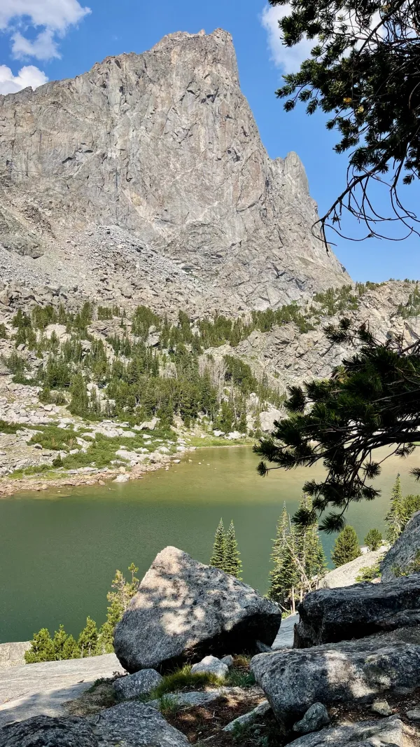
I saw Top O' as I crested the top of the pass. He had stopped there to eat lunch and wait for me. I have to admit I didn't pay much attention to him at first. I was preoccupied with the view of the Cirque of the Towers, which stretched out below.
The cirque has been called "an alpine climber’s Disneyland," and I can see why. It was ringed by several solid-rock pinnacles, spires, and one massive cone-shaped peak. I stayed at the top to eat my lunch and enjoy this amazing sight.
The mountain shaped like a cone is called Pingora Peak. It extends prominently from the others like a giant castle turret, jutting up 1,700 feet from the floor of the cirque.
Pingora and one other Wind River Range Peak are named in the book Fifty Classic Climbs of North America. The other peak is Wolf's Head, which is also in the cirque.

Lonesome Lake and Pingora
I lingered a little longer at the pass after Top O' left before I started the descent to the bottom.
Lonesome Lake covered most of the cirque's floor. I stopped at the shore to again take in the surroundings.

Polecat and Gravity in the Cirque of the Towers, 2010
I remembered Polecat and I stood at this same spot 11 years ago, and that brought to mind a funny thought. I had wanted since then to come back here. I figured there was a good chance I would, too. I just didn't imagine I would walk from Mexico to get here.
Honestly, it seemed a little surreal to be standing here after walking so far. I could not have predicted in 2010 all the events that led me back. I only had thoughts then of thru-hiking the Appalachian Trail, with no certainty that I would.
Seven more years passed before I did. And until I finished the Pacific Crest Trail two years later, I rejected any ideas of thru-hiking the Continental Divide Trail.

Steep climb toward Texas Pass
To continue north on the Cirque of the Towers Alternate, I needed to climb my third pass of the day, Texas Pass. I wasn't looking forward to this one, though I had not been this way before.
Polecat and I intended to take our group of scouts over Texas Pass in 2010, but when we reached the top of Jackass Pass, we realized that would be a bad idea. The route to the top of the next pass was covered in snow, and we didn't have any snow safety gear with us.
Snow wasn't going to be a problem today. Still, I figured from what I could see from Jackass Pass, the climb would be steep and strenuous.
Again, probably because I was in better shape today than I have given myself credit for, the climb wasn't as difficult as I expected.

Looking back from Texas Pass in the Cirque of the Towers
When I approached the top of the pass, I turned to look back at the Cirque of the Towers one more time. Now I could see Wolf's Head to the right of Pingora.
Smoke from fires northwest of here had diminished the clarity of the view, but it was still a magnificent sight. It was thrilling to be here once again.
Then I wondered, was this the last time I would see this view? I couldn't answer that question.

Looking north from Texas Pass
From my perspective at the top of the pass, the way down the other side didn't look too bad. There were a lot of rocks, but I figured so long as they were stable, I shouldn't have too much trouble. I just needed to stick with my standard hiking procedure: slow and deliberate.
Sandy trail on the descent from Texas Pass
My initial assessment was completely wrong. The descent was perilous, with loose sand and rocks nearly the entire way down. It was like the descent from Temple Pass except worse.
My feet slid with each step. Skating down the mountain felt similar to when I came down from Mt. Katahdin on the Saddle Trail near the end of my AT thru-hike.
I remembered a hiker fell that day and broke his hand. I didn't want to duplicate that here. Yet I nearly did. My feet slipped from under me, and I took a rolling tumble three or four yards down the trail.
After a moment of lying flat on my face, I slowly picked myself up, brushed off the sand, and checked all of my limbs to make sure I was unhurt. Satisfied I had no injuries, I became even more cautious as I continued down the slope.

A view of Texas Pass with the rock and gravel slope
When I reached the bottom, I turned back to take another look at the pass and the gravel chute-like trail that descended from it. Again, it didn't look horrible from here. Now I knew otherwise.
The drop from the top of the pass was 675 feet in three-tenths of a mile. It took me a full 45 minutes, including the pause to pick myself up after my tumble, before I reached the bottom. When I realized that, I was surprised it didn't take me longer.

Barren Lake
The mountains on this side of Cirque of the Towers weren't as tall or dramatic as the ones I had just passed. There also weren't nearly as many hikers on the trail.
The trail took me past large, beautiful lakes similar to the others I passed today. The first two were Texas Lake and Barren Lake.

Billys Lake
When I reached the next lake, called Billys Lake, I started to slow down a little. Top O' and I didn't discuss before we left this morning where we intended to stop tonight.
The time was now 5:30 p.m., which was a little early for stopping. Still, I didn't want to walk past where he stopped if he decided he was done for the day. Going over three passes had made me tired, and they probably made him tired too.
After passing Billys Lake and continuing to Shadow Lake, I discovered paths that went in different directions. This wasn't just a problem for finding the trail. There was no telling where Top O' might have turned if he saw a good campsite.
Large boulders were all around, some as large as a one-car garage. They would be nice for protection from the wind, but I couldn't be sure if Top O' hadn't pitched his tent behind one of them. I then examined the map more closely and guessed where he might have stopped.
That turned out to be the right spot. It was a large, flat area surrounded by trees and large boulders. Getting to the lake for collecting water was a little difficult, but I got what I needed near where Washakie Creek flowed into the lake.
Mosquitoes were another of my memories of Wind River Range from 11 years ago. By the time I got back to the campsite, they were becoming as bothersome as I had remembered, and I was soon inside my tent.
Although Top O' and I weren't entirely out of the Winds tonight, we were past the one area most people think of when they talk of it. That, of course, is the Cirque of the Towers.
Whenever I think of that magical valley of mountains now, I want to go back again. I don't dwell on whether or not I think I will, though. I'm done trying to predict the future.
Far greater things have already happened to me than I could imagine.
When will I see you again?
When will we share precious moments?
Will I have to wait forever?
Will I have to suffer (suffer)
And cry the whole night through?
When will I see you again?
When will our hearts beat together?
Are we in love or just friends?
Is this my beginning or is this the end? (is this the end?)
When will I see you again?
(When will I see you again?)
When will I see you again, love?
This trail report was published