A view from Poison Ridge

'Cause I'm sittin' on top of the world

Day 70, Arapaho Creek to saddle between Haystack and Parkview mountains

Monday, June 21, 2021

The mileage I hike each day tends to decrease as the elevation increases. Hiking in mountains is obviously more difficult at higher elevations. The terrain is usually rougher and the climbs are steeper. Bad weather is sometimes thrown into the mix.

That's no surprise, though I bring this up for a reason.

Weather Clear in the morning, then becoming partly cloudy; temperatures from the low-40s to upper-70s
Trail Conditions Steep climbs, many blowdowns, and a burn section
Today's Miles 11.5 miles
Trip Miles 972.5 miles

I can't always blame the mountains for why I am slow. Today was a prime example of that. I couldn't complete as many miles as I wished, and there were two additional reasons for that.

One was some dreadful trail conditions we encountered late in the day. We had to walk through an area devastated by a monstrous wildfire just eight months earlier.

The other reason, which came at the start of the day, was simpler. I was a victim of my own stupidity.

Middle Fork Arapaho Creek

The day started well. The sky was clear, and the temperature was cool.

I wasn't quite ready to leave when Top O' and OldTimer were, but I was only a few minutes behind them.

A large blowdown had to be crossed just a few yards from where we were camped. Rather than attempt to climb over the downed tree, I walked around it. When I reached the other side, I thought I was back on the trail. Instead, I unknowingly found a different well-warned path, which I followed.

I don't know what this unmarked trail was for, but it led me to the Middle Fork of Arapaho Creek. There wasn't a clear and easy way to get across, but I still didn't realize I wasn't on the CDT. I searched a couple of minutes for a suitable route across the stream.

A sketchy stream crossing on a downed tree

What I found was a busted, downed tree. This was a sketchy place to cross, but I managed to carefully make it to the other side without falling into the water.

From there, I continued on the footpath that wasn't as well-worn as before. When I came to another stream crossing, my brain finally received the warning signals that should have already been obvious. I was descending and crossing streams when I should have been climbing toward a ridge.

I pulled out my Guthook app and confirmed what I expected to find. I was far off the trail.

Unlike yesterday, when I was able to bushwhack a route back to the trail, I didn't see a possibility of doing that this time. The streams and the steepness of the terrain forced me to backtrack the way I came. Of course, that included crossing the same sketchy log I crossed a few minutes earlier.

The CDT near Hyannis Peak

At least an hour was wasted by my foolish detour. I was disgusted with myself for this mistake, even if the circumstances were somewhat understandable.

As soon as I stepped on the real trail, I began a long and steep ascent, the one I should have realized I wasn't climbing earlier. The route went up the shoulder of Hyannis Peak.

Looking in the direction of Hyannis Peak and Lost Ranger Peak

The mountain was 11,614 feet high. The trail didn't go over the top of it, however. It turned to go up a ridge and soon reached nearly the same elevation as the mountaintop.

From that height, I could look past Hyannis Peak to see Lost Ranger Peak, which we crossed four days ago. Plenty of snow remained on its top and on other mountains in the same range.

This was a strenuous climb, taking me up more than 1,000 feet in 1.6 miles. Still, I didn't want to stop for a break because I knew I was already more than an hour behind OldTimer and Top O'.

A cloud, not a forest fire

From the top of the ridge, I thought I saw the same fire I saw burning yesterday. Then a moment later I realized I wasn't looking in the same direction where the fire had been. I also noticed it only appeared to be a plume of smoke. It was a cloud instead and didn't extend to the ground.

This wasn't the first time I mistook a cloud for a smoke plume, and no wonder. The mountains cause some unusual effects on clouds, and the possibility of a forest fire is constant.

Volcanic rocks on a ridge

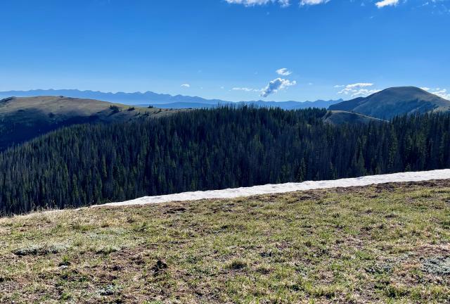
The trail I was now on wasn't just the CDT. Maps also identified it as the Top of the World Trail. Indeed, walking at 11,500 feet almost made me feel I was on top of the world.

I still felt an urgent need to push hard and catch up to OldTimer and Top O', but by 8:45 a.m., I had to stop for a break. I ate a snack bar to restore some energy. The magnificent view also helped with that, and I sat a couple of extra minutes just to enjoy it.

Poison Ridge

From the high point, the trail dropped about 600 feet before climbing again to go over a long and barren ridge. I tried to take advantage of the easier trail to make up for lost time, but I also didn't want to tune out the views around me.

A steep climb up Poison Ridge

Although the ridge included a couple of short-but-steep climbs, I felt strong enough now to take those on without slowing down as much as I had before.

A view of Haystack and Parkview mountains

The ridge gave me a view of Haystack and Parkview mountains. Before we left our campsite this morning, Top O', OldTimer, and I talked about possibly trying to get on the other side of Parkview today.

When I saw the mountain now, I knew there was no chance of that for me. If the other guys intended to go over the mountain today, it would be harder for me to catch up to them. That didn't worry me. I just didn't want to lose track of them for more than a day if I could avoid it.

Top of the World Trail on Sheep Mountain

Top of the World Trail and the CDT curved around the side of 11,818-foot Sheep Mountain and began an easy descent. I was cruising now.

Still, I assumed my slow climb and the break I took earlier had caused me to lose more time. I figured OT and Top O' were now at least 90 minutes ahead of me.

A climb on a ridge

This part of the trail wasn't all downhill yet. There was another short-but-steep climb to make before a continuous descent began. Then the next 3.2 miles went down 1,200 feet before arriving at Troublesome Pass.

The trail passed by a small parking area at the bottom, and I made a quick check to see if Top O' and OT were there. A small stream flowed a short distance up the trail on the other side, and I looked for them again there. I didn't expect to find them, but I wanted to be sure.

Feeling calorie-depleted again, I stopped for a short lunch break. I didn't get water, though, because I had enough to reach another stream less than two miles away.

Top O' on the CDT near Haystack Mountain

After finishing my lunch, I didn't go far on the climb that started from Troublesome Pass when I found Top O' and OT sitting by the side of the trail. They had begun to get worried about not seeing me all day and decided to wait for me. They told me they had been sitting there for about an hour.

Though I regretted they had to wait that long for me to catch up, it was much less time than that I had expected.

We left together, and despite the 1,300-foot climb in 2.1 miles, I managed to keep up with them. The trail took us up the slope of Haystack Mountain. The Continental Divide bisected the summit, but the trail stayed lower to go around it.

The first view of damage from the East Troublesome Fire

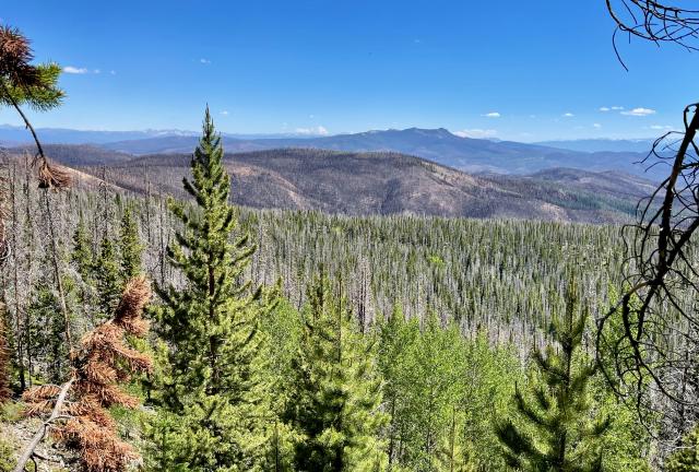
We knew from trail reports that we would soon have to cross a burned section of the trail. Before getting there, a view through some trees gave an idea of what we would soon find on the trail. A green forest was in front of us, but beyond it was a vast area of dead trees.

Though extending as far as we could see, we only saw a small fraction of the destruction left by the East Troublesome Fire, which started on October 14, 2020. More than 193,000 acres were burned.

The fire was small for the first few days, and firefighters thought it wasn't much of a threat. Everything changed three days later when the fire spread across more than 10,000 acres. Before long, it became a conflagration, consuming an incredible 6,000 acres per hour.

OldTimer climbs over a blowdown

We had already decided there was no chance of us hiking over Parkview Mountain today. This was confirmed when we began finding several blowdowns across the trail that slowed us down. They blocked the trail in several places before we had even reached the burn zone, and they were often horribly difficult to cross.

Forest fire damage on Haystack Mountain

The burn area was also slow to get through, but there were fewer trees to climb over or walk around. The fire destruction had been so complete there weren't many trees standing. It was a ghastly sight.

Returning to a green forest

Getting through the blowdowns and burned forest was exhausting. At last, we reached the end of the burnt and dead trees at 4:20 p.m. This wasn't the last of the devastation we would see from the East Troublesome Fire, but thankfully, it was the last we would hike through today.

A spring flowed a short distance from where the trees were green again. After checking the map, we saw we wouldn't have another opportunity to get water until reaching the other side of Parkview. I collected four liters.

I only had to haul it seven-tenths of a mile to our campsite in the saddle between Haystack and Parkview mountains. Still, that was a painful carry, which became worse when I slipped after leaving the spring. I fell hard and then had difficulty pulling myself up because of the extra weight of the water.

We found a good site for pitching our tents shortly before 5 p.m. Sunshine arrived about two hours later. No one was surprised he caught up to us.

I could have done without the first hour on the trail and the last couple of hours. The time between them was also tiring but much more enjoyable. The weather and scenery were gorgeous the whole time. That can make up for a lot of misery.

Mississippi River, so big and wide
Blonde-headed woman on the other side
Now she's gone, gone, gone and I don't worry
'Cause I'm sittin' on top of the world

This trail report was published on