
Days 14-15 Fort Valley Experimental Forest to Flagstaff
More from this trailI can see clearly now
I camped last night just inside the boundary of Fort Valley Experimental Forest. I wouldn’t have known about this if I hadn’t checked a map. There was no sign to mark the boundary, and the FarOut app didn’t mention it.
I also didn’t know until I researched it that this was the first Forest Service research facility in the U.S. It was established in 1908 after local foresters began to notice ponderosa pines were not regenerating after logging.
My campsite was on the west side of the San Francisco Peaks at nearly 8,000 feet above sea level. Though I didn’t feel any ill effects from the altitude, the temperature was noticeably cooler when I woke up this morning.
I knew I wouldn’t need my puffy jacket for long, but I continued to wear it when I started walking. I left camp at 6:30 a.m.
Last evening and early this morning, I heard strange noises coming from the direction of Snow Bowl Road. They sounded like construction activity, perhaps scraping metal and whirring engines. I wished I could see through the trees to know what was causing the racket.

Approaching Snow Bowl Road
Within a few short minutes, I arrived at the road. There was no sign of the source of those unusual sounds.
The road acted as a boundary for the no-camping zone. I intentionally stopped before getting this far last night. It seemed I made a wise choice to stop where I did because I didn’t see any potential campsites this morning on the way to the road.
Officially, this was the Flagstaff Area Permanent Fire Restriction. The perimeter was established to reduce the likelihood of human-caused wildfires around the densely populated city.

Flat, open space suitable for camping where it isn't allowed
Ironically, I saw several places that would have been perfect for camping as soon as I crossed the road. Or at least I was pretty sure they were good spots.
I was still hiking without my eyeglasses after they were stolen by a pack rat. To be honest, I may not have gotten a good look at the terrain.
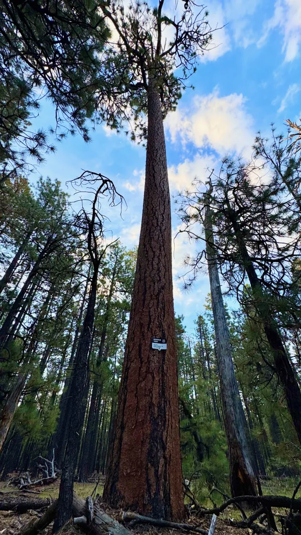
A reserve tree
At any rate, I saw well enough for a small sign to catch my eye. It was nailed to a tall ponderosa. But to read it, I had to walk much closer to it.

A sign on a reserve tree
The sign said, “Reserve Tree. Protect from damage or destruction.” This was something else I had to research later to know why it was there.
Reserve trees (sometimes called "leave trees" or "retention trees") are intentionally left standing as nearby trees are harvested. There may be one of several reasons for this designation. The tree could be a nesting site. Other tree species might depend on it. Seeds could be harvested for preservation. Or, the tree may be preserved to maintain long-term forest complexity.

A partially burnt area of the forest
As expected, I had to stop after walking only 40 minutes and remove my puffy jacket. I stopped again at 8:30 a.m. to eat breakfast.
The second break allowed me to use my phone and work out a plan for staying in Flagstaff. It took 45 minutes of checking maps and googling to do that, but it was worth the time. I wanted to stay overnight near the center of town, where I'd be close to stores and restaurants.
Surprisingly, the Embassy Suites was nearly the same price as other hotels in the area, so I made a reservation for a room there.

The Arizona Trail splits in two directions
There are two ways to hike the Arizona Trail as you approach Flagstaff. One is called Passage 32, also known as the Elden Mountain Route. That passage serves as the trail's equestrian bypass because it does not enter the city limits.
Going in that direction would require a long Uber ride to get to the post office or a store to buy fuel, which I needed to do.
The other option, Passage 33, goes inside the city limits. It is called the Urban Route and follows bike and walking paths. I chose to go this way because it would take me closer to the city's center and its bus system.

A distant view of Flagstaff
The Urban Route may sound like it's paved and cushy, but for the first few hours, it was just as rugged as any other trail. I figured most of the way would be downhill into Flagstaff, but that was not the case.
The trail meandered about with a few climbs. It did not take a direct route into the city.
I got my first view of Flagstaff from one of the hills. At this point, the trail was still following a single-track footpath, and it would be a few more hours before I was on a true urban path.

A wide, gravel path
When I finally reached the city-maintained trail, it was a wide, gravel path. I passed several people strolling on this flat, wide-open terrain and enjoying the pleasant weather.
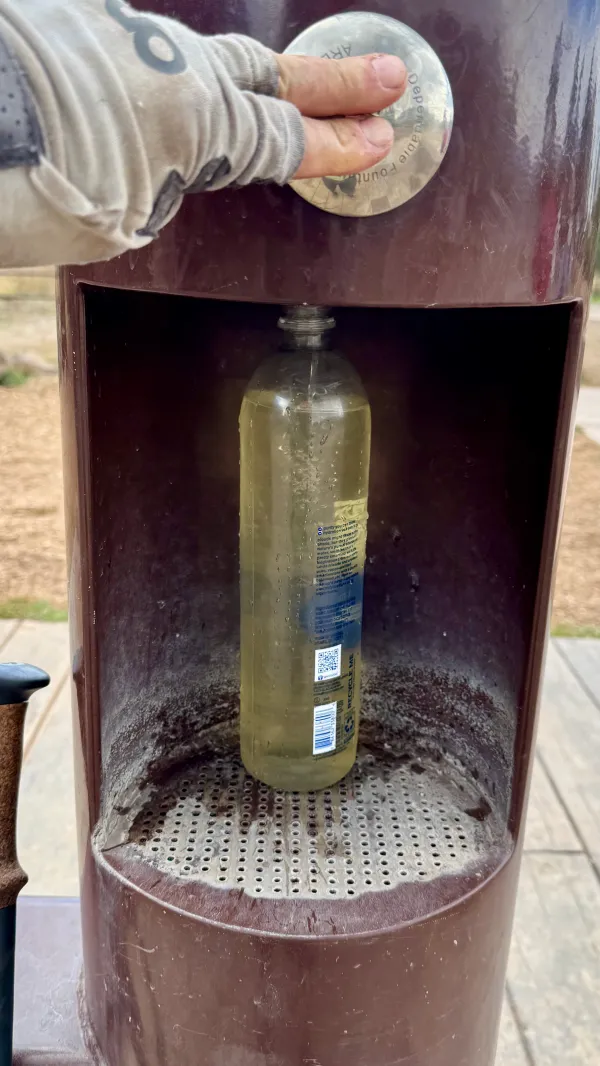
A water bottle refill station
There was even a water fountain on this path. Considering all of the nasty water I’ve had to collect and filter, drinking this felt like a luxury. It was also a necessity because I had been nursing the last of my water for a couple of miles.

Rain clouds over the San Francisco Peaks
The sky had been cloudy all day. Sometime after 2 p.m., I caught the scent of rain in the air. Looking back toward the San Francisco Peaks, I saw rain was falling. I couldn’t tell if it was evaporating before it hit the ground.

A taco stand in Flagstaff
I left the trail at Old Route 66, a main road into Flagstaff. This was part of the same historic highway I briefly walked on during my 2021 Continental Divide Trail thru-hike. The buildings along the road here in Flagstaff were much less rundown than in Grants, N.M.
I found a taco stand just off the trail, so I bought a taco and a drink. Then I walked to a nearby shopping center. This seemed like an easier spot for an Uber driver to find me, and I ate my taco while waiting for her.
As soon as the driver dropped me off at Embassy Suites, she pulled out a can of Lysol and sprayed the seat where I sat. I had to laugh when I saw this and didn’t take offense. I also gave her an extra tip.
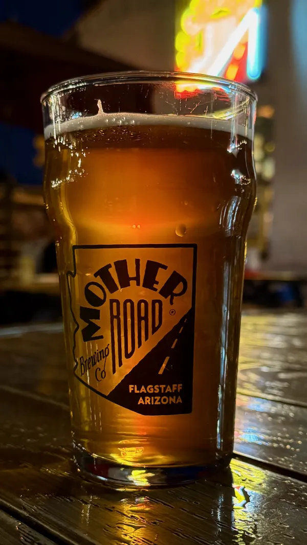
A beer at Mother Road Brewing
The hotel wasn't just near a large grocery store and an outfitter store; it was also near a couple of breweries. How could that be more ideal for a thru-hiker? I went to Mother Road Brewing for dinner, and decided to wait until tomorrow to do my shopping when I go to the post office.
Unfortunately, I soon discovered my package hadn’t arrived there yet. The tracking information said it was in Phoenix. Supposedly, it would arrive in Flagstaff tomorrow, but it wasn't promised to arrive until 9 p.m.
I wasn’t planning on taking any zeros on this thru-hike. Now I had to.
It takes two to three weeks for a thru-hiker’s body to adapt to the daily routine of walking all day long. Mine was just starting to kick into thru-hiker mode the last day or so. I figured extra rest would do me some good and didn’t mind the delay in receiving my package. My only regret was going without my eyeglasses for a few more hours.
A chance for extra rest didn’t turn out as I hoped, however. I slept poorly last night. Children were running constantly from one end of the room above me to the other. I kept thinking, “Surely the parents will send those kids to bed soon,” but the noise didn’t stop until past 11 p.m.
Making matters worse, I was worried about what was going on in Western North Carolina. I had just started to get details about the destruction left by Hurricane Helene. The news came to me in a slow trickle, and even my wife didn’t know much about the situation.
Our older son and his family live in Asheville, N.C. Their water wasn’t drinkable, and their power and cell service were out. It took a while before we got any real news. Entire sections of the city were wiped out by floodwater. Thankfully, my family was safe, but their house and car were damaged.
The devastation impacted every part of their lives, and my impulse was to leave the trail, go to Asheville, and help my family any way possible. When I talked over this idea with my wife, she told me it was impractical.
Floods and landslides wiped out roads into the city, she explained. There was no way to drive from our house to our son's house. Even if I could get there, without power or water, there was little I could do.
Though I was grateful to know everyone was holding up under severe difficulties, I felt powerless.
After breakfast, I tried to take a nap, but was still too restless to sleep.

A Flagstaff bus stop
Later, while doing my laundry, I learned my package had arrived at the post office. This was slightly annoying because I could have saved some money by checking out of the hotel and picking up the package on my way out of town. It was too late for that now.
Getting to the post office was easy. A central bus terminal was a short walk from the hotel, and after a 35-minute ride, the post office was another short walk away. If I wanted, I could have ridden the bus all day for $1.25, but that's not my idea of a good time.
The postal clerk needed several minutes to find the package my wife sent, which worried me a bit. After he finally showed up with the package, I immediately put on my spare pair of glasses, then took a selfie for my wife to share in the happiness of my restored eyesight.
Filling out my election ballot, which my wife also sent to me, turned out to be a challenge. There were no pens in the post office to write with. I had to walk to a nearby bank, borrow a pen there, then walk the ballot back to the post office and mail it.

Gravity standing next to an astronaut statue
Returning to the bus stop, I discovered that a motel had an astronaut statue. I have no idea why, but it seemed worthy of another selfie while I waited for the return bus to downtown.
I completed my other town chores when I got back downtown, one of which was devouring a large pizza by myself. This was further proof I was nearing true thru-hiker form.
I also spent time researching the next leg of the trail. That’s when I discovered there was a closure because of a large wildfire near the village of Pine.
Would I have to skip that section? It seemed so, but I wasn’t certain. This could be troublesome for completing the whole trail this year, I thought.
I could see clearly now with my replacement glasses, but there was still much I couldn’t see. What’s going on in Asheville, and should I be there? What’s ahead of me on the trail? Will it alter my hike? I didn’t know, and that was frustrating.
As I prepared to return to the trail, I began to wonder if I should even be here.
I can see clearly now, the rain is gone
I can see all obstacles in my way
Gone are the dark clouds that had me blind
It's gonna be a bright (bright), bright (bright)
Sun-shiny day
It's gonna be a bright (bright), bright (bright)
Sun-shiny day
This trail report was published