
Day 32 Two Bar Ridge to Reavis Saddle
More from this trailHell's bells
Hikers have occasionally reported hearing rumbling noises while hiking on a clear day in Superstition Wilderness. Geologists say the rumbles come from minor seismic activity underground that resonates off canyon walls.
The Apache people also said they heard noises, and attributed them to a source deep below the mountains. In their tradition, the rumbles came from a portal to the underworld, or hell. They said the deep, reverberating sound came from wind blowing out of the hole, which caused dust devils to spin up.
I was awakened at 2:00 this morning by a rumble. Though I can’t prove the source was or wasn’t the underworld, a strong wind began to shake my tent. I also felt the temperature dropping rapidly.
After making a few adjustments to my quilt and the tent, I fell back to sleep and remained warm until morning.

Dawn in Superstition Wilderness
There was only a light layer of clouds high in the sky when I crawled out of my tent at 6 a.m. The wind had already decreased by then and would continue to drop. The sun hadn’t yet risen above the horizon, but there was just enough daylight to see as I began to pack and prepare for the day.
A hiker named Jenny stopped for a moment as I was almost done packing. She told me her trail name was Phantom, but she wasn’t sure she wanted to keep it. We only talked briefly, and I didn’t get a chance to ask her how she got the name or why she wasn’t sure it suited her.

Looking across Two Bar Ridge
For the first 1.5 miles of the day, the trail followed the top of Two Bar Ridge. I was now in the heart of the wilderness. At this elevation of 4,600 - 4,800 feet, the ruggedness of the land was obvious.
Between 17 and 25 million years ago, this place probably looked the way most people think of hell. It was a terrain of intense volcanic activity. Volcanoes covered this area in a thick layer of ash and lava before they collapsed into a massive caldera. Upthrusts of lava continued, then cooled before finally eroding into the landscape I saw today.
The elevations of Superstition Wilderness range from around 2,000 feet to its highest point, Mound Mountain at 6,265 feet.

A distant view of Four Peaks
The Four Peaks stand much higher, between 7,526 feet and 7,659 feet tall. I could see them on a long, steep descent into a dry canyon.
This drop had barely ended before I had to start a brutal climb. It took me a long time to reach the top.
As a much younger hiker with long legs passed me, I managed to suppress a few jealous expletives to throw his way. It wasn’t his fault he was young and tall, just as it wasn't my fault to be old and short. Regardless, I was annoyed he could pass me so quickly and effortlessly.

Walnut Spring
Yet another descent came after the difficult climb. This time, at least, it wasn’t as steep or long.
Walnut Spring was at the bottom. The FarOut app reported water was flowing from the spring, but it was difficult to find. I walked past the spot without seeing it. Eventually, I realized FarOut’s map placed the spring on the wrong side of the trail.
A thick mat of tall grass didn't make it any easier to find the spring, but I'm glad I eventually did. I needed all the water I could carry on this hot day. The spring box was filled with cloudy, brown water, but it filtered reasonably clear.
Even though a previous hiker reported in FarOut that a rattlesnake had taken up residence here, I didn’t see it.

Ankle-twisting rocks on the trail
The next few miles of the trail weren't as steep, though they were littered with small rocks and larger boulders.
I tend to step slowly and carefully when I’m on a footpath like this. I’m always wary of twisting an ankle. That’s happened too many times, but I didn’t have a problem this time.

A stack of tools used for trail maintenance
I came upon a stack of shovels, McLeods, and Pulaskis a couple more miles up the trail. These were the tools of a trail maintenance crew. Today was Saturday, and they must have taken the day off. I saw no one working on the trail.

The trail follows the side of a ridge
There was another big climb about seven miles into the day. It went up to about 5,200 feet.
I wasn't planning to take a break until I finished a descent on the other side of the climb and reached the next water source. Nevertheless, when I saw a rock covered in shade, I couldn’t pass it up. I had been feeling the effects of the scorching-hot day and was desperate for a break.
I ended up taking full advantage of the spot by staying there to eat lunch.

Two weekend backpackers at Reavis Ranch
The trail dropped into an area known as Reavis Ranch. And at last, I found some extended relief from the heat. The canyon was filled with shade trees.
I was confused for a moment. The trail wasn’t marked. As I stopped to check the map, two weekend backpackers arrived. They said they knew the way and intended to camp nearby tonight. While they were here, they hoped to find an old apple orchard.
The two men explained that Reavis Ranch was owned many years ago by a hermit. I learned more about him later when I had time to do some research.
Elisha Marcus Reavis (1827–1896) was known to Anglo settlers as the "Hermit of the Superstitions." The local Apache reportedly called him the "White Devil." Reavis built his ranch in the mid-1870s and lived here for more than 20 years. He may have been the first white man to live in the Superstition Mountains.
Reavis was often called a hermit because he only went into towns and mining camps every few months to sell his produce. Though he looked the part, with shabby clothes and a full beard, he was college educated. Those who knew Reavis said he was an intelligent conversationalist. He maintained a large, personal library on his ranch.
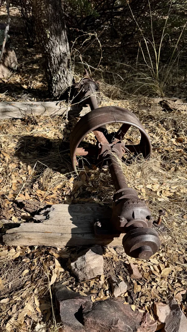
A rusted axle
There were only a few signs of the ranch today as I walked along the trail. Some were rusting remnants of farm equipment. They were too modern to be owned by Reavis, however.
After he died, other homesteaders owned the property, and a Boy Scout camp was located here in the 1920s. The land was purchased by the U.S. Forest Service in the 1960s.

The foundation of a house in Reavis Ranch
I saw a few bricks and the foundation of a building that burned down in 1991. I don’t know if that was where Reavis lived, but there’s a story about his ranch that allegedly involved a party of Apache warriors. It might only be a local legend.
As the story goes, Reavis was holed up in his house, fighting off an armed band of Apaches. When he ran out of ammunition, he decided his only chance for survival was to act crazy. He stripped naked and charged at the Indians with a butcher knife in each hand. They fled and never returned.

An overgrown section of trail
The two men I met when I arrived at the ranch area never found the orchard they were hoping to find. I’ve seen pictures of apples that came from the orchard, and they looked tasty.
I passed several more weekend backpackers and paused to talk to a few. Then I stopped to collect water from the creek that ran through the valley. Though I still had nearly a full liter of water from Walnut Spring, I scooped and filtered three more liters. I wanted to take advantage of easy access to clear-flowing water, knowing there weren’t many spots like this on the trail.
Beyond the ranch area, the trail veered away from the creek and became overgrown with tall grass. Again, I had some trouble finding the trail. Much of this area had been severely burned in the 2019 Woodbury Fire. The grasses were the quickest vegetation to recover.
The fire was one of the largest to hit the state, covering 123,875 acres. Although authorities say it was a human-caused fire, they didn’t specify exactly how it started.

An ancient alligator juniper
The trail was now making a gradual climb, a pleasant change after the tiresome ups and downs I had to follow this morning.
A huge alligator juniper tree stood in this section. It had been damaged but not destroyed during the Woodbury fire. It survived thanks to the protection given by firefighters.
Alligator junipers are common in Arizona. Though they don’t usually grow as large as this one, some have been documented to be 500–800 years old.
When you see the bark of an alligator juniper, you understand how it got its name. The tree trunk has a thick, square-plated pattern that looks exactly like alligator hide. No other juniper trees have bark like that.

Tall grass in a canyon
Farther down the trail, there was only a faint path to follow. It had become so overgrown, I had to stop several times and make sure I hadn’t wandered off the trail.
It was along here that I met a hiker named Moonjuice, who was hiking in the opposite direction. He told me he had hiked the Arizona Trail several times and offered tips about the trail ahead.
Moonjuice encouraged me to stay with a trail angel named MJ when I reached Superior, the next town ahead, and I made a mental note of that.

Mule deer
Soon after Moonjuice continued on his way, I saw several mule deer eating dinner in the tall grass.
At 4 p.m., I had only about 90 minutes of daylight left. I hadn’t hiked as many miles as I hoped today, so I tried to pick up my pace. Despite the cluttered trail, I wanted to add a few more miles before sunset.

The sun sinks behind a mountain
An hour later, I came to an overlook at the end of the long, steady climb out of Reavis Ranch. From there, I could see that the trail was about to make a significant, steep descent into another canyon. The trail looked rocky on the way down.
From that vantage point at the top, it was obvious I would have to slow down my pace. It seemed unlikely a campsite would be found until I reached the bottom, and I doubted I’d get there until well after dark.
If I thought a campsite could be found a reasonable distance away, I would have kept going. The only site I knew about, however, was one I had just passed.

A campsite in Superstition Wilderness
I didn’t have to backtrack much to get to that campsite. Even though I was stopping several minutes earlier than I preferred, the site could not have been better. It was large, flat, and offered a lovely view.

Minutes after sunset
It didn’t take long after I stopped for the sky to fade to deep oranges and reds, then become dark.
I enjoyed this day, but still, I had wanted to hike farther so I could reach Superior tomorrow. Now I wasn’t sure if I could. A big climb, two water stops, and conversations with other hikers took more time than I intended to spend.
Like every day on the trail, I'll just have to take tomorrow as it comes, and see if I can make it all the way to Superior. It still seems possible. I just have to make sure I don’t get swallowed up in a portal to hell.
I'm a rolling thunder, fire and rain
I'm coming on like a hurricane
My lightning's flashing across the sky
You're only young, but you're gonna die
I won't take no prisoners, won't spare no lives
Nobody's putting up a fight
I've got my bell, I'm gonna take you to hell
I'm gonna get ya, said I'll get ya
Hell's bells
Yeah, hell's bells
You got me ringing hell's bells
My temperature's high
Hell's bells
This trail report was published