
Day 23 Pine to Whiterock Mesa
More from this trailAnd the most you can ever do is the best you can
My short stay in Pine provided everything I needed at that moment. Besides completing the tasks of a routine town stop – washing my clothes, resupplying for the next section of the trail, and consuming plenty of extra calories – I did something more valuable. I confirmed I still wanted to stay on the trail. After this stay, no doubts lingered about my decision to keep going.
My only disappointment with the stay was discovering the community’s small brewery, THAT Brewery & Pub, was closed, but I managed to get over that.
The brewery has a reputation for being hiker-friendly. One of the beers produced there is a pale ale called Arizona Trail Ale. A portion of the beer’s sales is donated to the Arizona Trail Association. Though I wasn’t able to drink one here, I enjoyed that beer on Day 2 at Jacob Lake Inn.
Despite complaining for several days about a monotonous trail, I should have counted a blessing from it. Except for the Grand Canyon, there were only a few steep ascents and descents north of the Mogollon Rim. The rest of the trail was flat.
From now on, the trail will be more challenging. There will be fewer forests to provide shade, so there will be long stretches that are exposed to the sun. I will cross rugged terrain with steep inclines and many rocks.
As a bonus, there will be many more cacti along the trail. They can rip at my clothing and skin if I’m not careful.

Cyndi, owner of Beeline Guesthouse
Cyndi, the pleasant owner of Beeline Guesthouse, offered to drive me back to the trail this morning. It was a short trip because the trailhead was just 1.5 miles from Pine.
I began walking at 8:15 a.m. and resumed my journey south. My next town stop won't be far. The distance from Pine to Payson is much shorter than the segments I’ve walked so far on the Arizona Trail. The only issue with getting to Payson will be that it is several miles away from the trailhead.
Most of the distances between trail towns for the rest of the AZT will also be shorter. I will appreciate this because I won’t have to carry as much food weight in my pack.

A rocky trail
Almost immediately after I started walking, the trail began one of the steep ascents I mentioned. Here, the trail was littered with small, loose rocks. They made the climb difficult because they often rolled as I tried to get traction.

The trail begins a steep climb
The trees and shrubs were now smaller than they had been above the Mogollon Rim. Thankfully, they were green and not burnt. The West fire that burned a few weeks ago, which consumed large parts of the trail I walked the last two days, did not reach this part of the trail.
The alligator juniper, manzanita, alderleaf magnolia, and scrub oak here were not large enough to provide much shade, but I wasn’t sweating. The dry, morning air was cool.

A distant view of the Mazatzal Mountains
The first climb wasn’t the worst of the day. It went up 300 feet, which was enough to be a good wakeup call for what to expect for the rest of the day.
At the top, I found a long view of the mountains ahead. The peaks in this range were between 4,000 and nearly 8,000 feet high. They were the Mazatzals, sometimes nicknamed the "Mazel Tovs" because of the similarity in names.
The origin of the name is a little obscure. It probably did not originate from the Apache, the indigenous culture that lived here most recently. The name is thought to have been derived from a Nahuatl word for "place of/land of deer."
Nahuatl was the language of the Aztec Empire, though the Aztecs did not live this far north. The Apache didn't speak a language based on Nahuatl.
Most likely, the word “Mazatzal” came from the Salado culture, who probably borrowed words from the Aztecs. They settled in the area around 700 CE.
The Salado began to leave the area between 1350 and 1450 CE when the land became more arid, making it difficult to continue growing their crops.

Big rocks on the trail
I took a short snack break at 10:15 a.m. By this time, I had only walked a little more than three miles. The trail was still extremely rugged, keeping my pace slower than I had hoped.
By now, the trail had already dropped 400 feet and was starting another climb. This one was longer and steeper than the first.

Cactus next to the trail
The next 2.6 miles would gain 800 feet of elevation and included some gut-punching steep grades of up to 20 percent. Thankfully, there weren't as many rocks covering the footpath as before.

The trail leaves a dirt road
At 11:30 a.m., the trail switched briefly to a dirt road before returning to a single-track trail.

A member of a trail maintenance crew named Noah
I didn’t get far on this section before I met five members of a trail crew who were clearing and improving the footpath. I talked to one of them, who told me his name was Noah. He said he was from Denmark. When I remarked that he didn’t have a noticeable accent, he explained that his mother was American.
Every time I have talked to someone on a trail crew, they have told me they enjoyed the work. Noah was no exception. He said he works eight days on the trail, then gets six days off in Flagstaff. Before coming to Arizona, he worked on the Pacific Crest Trail.

Another view of the Mazatzals
I stopped for lunch at 11:45 a.m. when I found a spot to enjoy another long-distance view of the Mazatzals. Spots like this provided a cool breeze.

Entering Mazatzal Wilderness
I enjoyed a relatively flat section for nearly 2.5 miles before the trail entered Mazatzal Wilderness. Federal protection of this area predates the passage of the Wilderness Act of 1964. It was named a Primitive Area in 1938 and given additional protection in 1940.
The Mazatzals were among the first 54 areas selected when the Wilderness Act was signed into law by President Lyndon B. Johnson. At that time, the wilderness area was expanded to more than 252,500 acres.
Starting at the wilderness area’s northern boundary, the trail began a long descent that was covered in many rocks. Just before I began the descent, I stopped for a short snack break and realized I was running a little low on water.
Unfortunately, I had already passed up my last chance to get water for a long distance. I decided to make do with what I had. I’d have enough for dinner tonight by staying mindful of what I had. If I didn’t get to the next reliable source today, I wouldn’t have to go far to reach it in the morning.

A closer view of the Mazatzals
For the next 4.6 miles, the trail made a continuous drop into Rock Canyon. This descent was 1,400 feet, and again, was sometimes steep.
The terrain shifted from small trees, mostly piñon pine, to desert broom, prickly pear cactus, and agave.
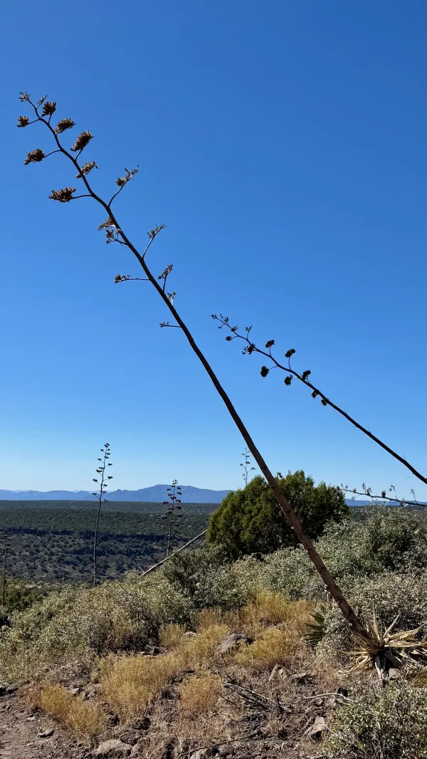
Palmer’s agave
The dried flower stalks of Palmer’s agave stood ten to fifteen feet high. They looked like spears that had been flung from a great distance before stabbing the ground.
This agave is sometimes called the century plant. After growing for several years, it blooms only once, then dies.

A gate made with stacked rocks
At the bottom of the descent into the canyon was a creek bed. In wetter seasons, I could have gotten water here, but the creek was dry today.
Nearby was a fence and a gate, which reminded me of similar gates I saw on the Pacific Crest Trail in California. There were few trees around here large enough to make a sturdy gate, so rocks were stacked for the gate opening. The rocks were wrapped in wire fencing to hold them in place.

The trail on Whiterock Mesa
The climb out of the canyon was not nearly as long as the descent, but there was another steep and rocky section.
The trail then continued along Whiterock Mesa, which was mostly flat and had several small trees.

Rocks that look like dinosauer bones
The most unusual sight of the day came soon after I began crossing the mesa. I found piles of rocks that looked like stacks of dinosaur bones. They had been stacked as cairns and also laid out in rows to mark the trail. The rocks were white and oddly shaped, almost like petrified coral from an ancient sea.
With some research, I learned the rocks were erosionally sculpted limestone. They are natural formations created when limestone is dissolved and weathered by water, wind, or chemical action.
The time was now 5:15 p.m., and I was still about 1.25 miles from the next water source. Taking another look at the map and elevation profile, I saw the water was a spring on a steep slope descending from the top of the mesa. This told me no camping spot was likely to be found near there.
Although I might reach the water before dark, the sun would set before I finished collecting water. That meant I'd have to find a campsite in the dark. Instead, I chose a spot to camp on the mesa’s flat ground, even though the unusual rocks were a little creepy.
While setting up camp, two hikers came by. I had talked to them briefly yesterday while I was at the restaurant in Pine, and now I learned their names. They were Charlie, who was from Vancouver, and Bubble Wrap, from Washington. With daylight fading fast, they didn’t stay long before moving on.
I didn’t complete the mileage I hoped for today, but I also started hiking two hours later than usual. Given that and the occasionally rough terrain, the 15 miles I completed seemed very satisfactory. I did the best I could today, and that was good enough.
Looking at what I see
What does living mean to me
All that I can ever be is just a man
And the most you can ever do is the best you can
Riding on the world go round
Being me and what I am
What I am, I'm just a man
And the most you can ever do is the best you can
This trail report was published