
Day 10 Coconino Rim Road to Babbitt Ranch Passage
More from this trailLord, they're setting us on fire
Why did I feel so drained yesterday? What made me sluggish when the trail conditions should have been easy?
I still don't know the answer. I couldn’t blame the elevation. My fluid intake and nutrition weren’t at fault. Yes, the scenery was monotonous, but my mood shouldn't have affected me as much as that.
Without knowing what wore me down, the only thing to do was get a good night’s sleep and try again today.
To my relief, that’s exactly what happened.
I slept well overnight. My alarm was set for 5:30, a little later than yesterday, after I realized 5:00 was too early.
While I prepared to get back on the trail, Hush, Side View, and Emma pulled up in their car. They were on their way to drop off Emma. She had slackpacked for the last few days and was about to begin hiking without support from her parents.
After she is dropped off today, Hush and Side View will begin driving back to their home in Kansas.

Early morning sun on Coconino Rim Road
There wasn’t much sunlight when I started walking. I could have made my way back to the trail, but instead, I stayed on Coconino Rim Road because I knew the trail would soon cross it.

A large road sign warns of smoke ahead
Before I got to the junction, however, I came upon a sign near the intersection of another road that warned about smoke. There was a light amount of smoke in the air, but no information about a reroute of the trail.

Smoke rised from a burning tree stump
Wisps of smoke rose from a few smoldering tree stumps. There were no fire crews to be seen, but it appeared that a controlled burn had taken place here the previous day.
I looked around to see where to go. Should I turn at the road or continue ahead to the trail?
I decided to keep going to the trail. Maybe I'd find more information there.

Information about a prescribed burn is posted on a large board
That turned out to be true. A notice and a map were posted on a large board. They announced a prescribed burn that was underway by the U.S. Forest Service.
The burn was originally scheduled for a different location, but unfavorable conditions forced a change to this area.
I needed a little time to get my bearings by matching the board’s map with the one on my FarOut app. That's when I realized the alternate route I saw yesterday in FarOut was also the Forest Service’s reroute.
But I also found a problem here. I needed to get to Russell Tank, the only water source that was available today. The three water sources beyond it were reported to be dry.
It took a couple more minutes of studying both maps to figure out a way to Russell Tank.

Sunlight filters through smoke
To follow the reroute, I had to backtrack to the road where I saw the first sign. According to the Forest Service's map, this was a boundary for the burn operation.
As I walked, smoke was on my left, and clear air was on my right.

The road fades to grass
To reach Russell Tank, I had to leave the reroute and follow the FarOut map. It showed a road leading to the tank, but that turned out to be a faint road that eventually faded to nothing but grass.
I kept walking in that direction anyway and assumed the tank would appear soon.

Russell Tank, seen through a fence and trees
It wasn’t long before I saw the tank, but an old barbed-wire fence blocked my way to it. After scouting around, I found a makeshift gate, and with a little struggle, managed to open it.

Russell Tank
This was an unusual tank. Despite its name, it didn’t appear to be used for livestock, which is usually the purpose of desert tanks. This was a stream that had been dammed to retain much more water than usual. The U.S. Forest Service says Russell Tank is large enough to be stocked with fish when enough water is available.
Before collecting water from the tank, I ate breakfast while also watching and listening to birds. I either saw or my Merlin app identified turkeys, Steller's jays, dark-eyed juncos, common ravens, and red crossbills. I'm sure there were many others.
The water in the tank was sludgy, so I used my bandana for a pre-filter as I collected it. Because the next reliable water source was 18 miles away, I filtered enough to fill three one-liter bottles, then filled a 2-liter bladder with unfiltered water. That was the equivalent of about 1.32 gallons, which added 11 pounds to my pack.
I hoped to reach the next water source today, but if I didn’t, I probably had enough to get me there tomorrow morning.

A small plume of smoke rises in a forest
I thought about rejoining the trail, which was near the tank. There wasn't any smoke here, but instead, I returned to the Forest Service road.
Though I hadn’t seen any active burning so far, I wanted to avoid smoke as much as possible. The reroute didn't look like it would add much extra walking distance.

Smoke appears ahead at the end of a road
The smoke was a little thick at times, but it was never so bad that I felt a need to wear a mask or bandana over my mouth and nose.
Some of the worst smoke was at a road junction. That’s where I met Bob Blasi, who was supervising the burn.

Bob Blasi
He showed me a map of where crews were burning today and offered to drive me around the smoke.
I explained that if walking wasn't dangerous, I preferred to keep my footsteps connected. He said I should be fine, but if the smoke becomes bad, I could wear an N95 mask.

Smoke rises from a meadow
There wasn’t much wind today, so most of the smoke went straight up. And of course, the lack of wind was why the crews were burning today.

Grass and small shrubs burn
Continuing along the road, I passed a meadow where crews were igniting new fires. One of the crew members said I should check with a supervisor who was sitting in a truck to make sure it was okay to walk this way.
He explained that the Forest Service sometimes drops spears from a helicopter that will ignite the center of an area, which can be dangerous.
Bob Blasi arrived at that time, and he told me I would be fine to continue down the road.
I stayed there several more minutes talking to Mr. Blasi. He told me prescribed burns are conducted using scientific calculations based on humidity, wind speed and direction, and other factors. The prescription allows the Forest Service to set fire to grasses and small shrubs without burning all of the trees.
The meadows and forests will start to green up within a year, he said, and within two years, it will be impossible to tell they had been burned.
Before leaving, I asked Mr. Blasi if he could find some water to top off my water bottle. I guessed the crews had plenty, and that was correct. I was able to refill a liter bottle. He also gave me some smaller bottles, and all of the water was cold.
I had no doubt now I could reach the next water tank before running out.

A helicopter flies above the site of a prescribed burn
After walking about a quarter mile down the road from the burn area, I saw a helicopter. I stopped for a minute or two to watch it fly overhead, but I was disappointed that no spears were dropped from it.
When I stopped for lunch, another Forest Service supervisor stopped his truck and asked if I was doing okay.

A battered old sign marks where Moqui Stage Station once stood
A short time later, I passed a battered old sign that marked the site of the Moqui Stage Station. There wasn't much else here, which had been a stop on a stagecoach route between Flagstaff and the Grand Canyon that operated in the 1890s. Passengers could make the 12-hour trip for a cost of $20.
The word "Moqui" refers to the Hopi people, a Native American tribe in Arizona and New Mexico. They consider the term derogatory.

A distant view of Humphreys Peak
I rejoined the official Arizona Trail route near the Moqui Stage Station site. Before long, I began to see Humphreys Peak, the highest mountain in Arizona.
At the moment, the 12,637-foot mountain was more than 30 miles away, but I would be passing directly by it in the next couple of days. The AZT does not go over the top.

Missing Person
At 3 p.m., I met the only hiker I would see all day on the trail. He told me his trail name was Missing Person, and he was finishing the section of the AZT from Flagstaff to the Utah border.
Missing Person said he had met several southbound hikers, perhaps 10 or more. We exchanged information about water sources ahead on the trail.

Entering Babbitt Ranch Passage
Soon after our conversation ended, the trail led me into an area called Babbitt Ranch Passage. The trail was now a single track and was occasionally very rocky. Other sections were smooth and sometimes sandy.
Shortly after I entered this section, I stopped for a break. The time was now 3:45 p.m., and I knew I no longer had enough daylight to reach the next water source today as I hoped. Nevertheless, I was still carrying plenty of water. I've been constantly thirsty, but I didn’t need to find more water until tomorrow.
And because I didn’t need any more today, I could take a 15-minute break without worrying about the time. It was turning into a surprisingly good day, I thought. I was hiking at a decent pace, despite several long stops along the way.

A look back to where the prescribed burn took place
During my break, I looked north and saw an enormous cloud of smoke billowing from where I had been a couple of hours ago. The prescribed burn turned out to be a larger operation than I first realized.

Broken clouds in the sky
The AZT is divided into sections called passages. They are numbered, starting at the Mexico border, and ascending northward. I presume the divisions were made for the convenience of section hikers and day hikers. Admittedly, I’ve paid little attention to the passages because I’m attempting to hike all of them. Babbitt Ranch Passage is Passage 35.
Babbitt Ranch is land owned by the Babbitt family under a corporation called Babbitt Ranches. The business was begun by five brothers who moved to Arizona from Ohio in 1886. Along with ranch land, the brothers operated a department store in Flagstaff and several Indian trading posts. Today, the company owns 700,000 acres of land and raises 8,000 head of cattle.
Bruce Babbitt, a former Arizona governor and President Bill Clinton’s Secretary of the Interior, is a descendant of one of the original Babbitt brothers.
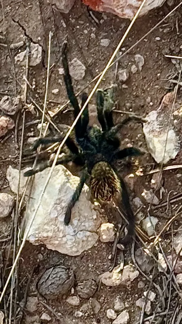
Grand Canyon black tarantula
Late in the day, as I began to look for a potential campsite, I was fortunate that I also kept an eye on the ground. I almost stepped on a tarantula.
There are more than a thousand varieties of tarantulas. This one was a Grand Canyon black tarantula.
Although tarantulas spend much of their lives in underground burrows, it was not unusual to see one today. Males leave their burrows in the autumn to search for a mate. Females live up to 30 years, while males have a much shorter lifespan.
Tarantulas like this one are venomous, and though a bite from one is painful, it is not deadly. The bite is similar to a wasp sting.

Looking across Babbitt Ranch Passage
After combing through comments in the FarOut app, I found a spot that appeared to be suitable for a campsite. It was just ahead, and I could arrive and set up camp before sunset.
It turned out to be a lovely spot on a short ledge with a view of Humphreys Peak. As a bonus, I had one bar of cell service, so I called Kim. She told me my mail-in ballot had arrived at home. I said I would figure out where to mail it to me so I could fill it out and send it back before the upcoming election.
Although I ended about four miles short of my goal, which was the next water source, I was satisfied with my progress today. I didn’t feel nearly as tired as yesterday. My pack was able to handle the weight of the extra water I carried. I got a little education on what goes into a prescribed burn. And I completed more than 19 miles, which was the farthest I've hiked so far on this trip.
When I crawled into my quilt, which was set up cowboy style without a tent, I was feeling much more positive about my hike than yesterday. What I didn’t know – couldn’t know – was the trouble I was about to face, which was lurking just steps away.
They're a band beyond description
Like Jehovah's favorite choir
People joining hand in hand
While the music plays, the band
Lord, they're setting us on fire
This trail report was published