
Day 1 Northern Terminus to Old Arizona Road
More from this trailAnd I've got such a long way to go to make it to the border of Mexico
Getting to the terminus of a long-distance trail is often complicated. It's almost always far from towns.
The Arizona Trail is no different. Traveling to the northern terminus from my home in Tennessee required three flights, an overnight stay, and a hired shuttle. The terminus was more than 45 miles from Page, Arizona, the nearest town.
Surprisingly, my trip went smoothly.
I usually try to get an early start when I begin a new trail, but for this hike, I scheduled my shuttle driver to pick me up this morning at 10:00. The extra time allowed me to walk from my hotel to Page's post office to send home a box of clothes I wore on the plane yesterday.
On my way back to the hotel, I stopped at a Mexican restaurant painted in bright colors. The paint failed to mask that the building was a former Taco Bell.
I bought two breakfast tacos to go, which I intended to eat after I was dropped off at the trailhead. By the time I got back to the hotel, however, I had decided to eat the tacos while waiting for my driver to arrive. This was as if I had hiker hunger, but of course, it was much too early in the hike for that.
Gravity at the start of the Arizona Trail
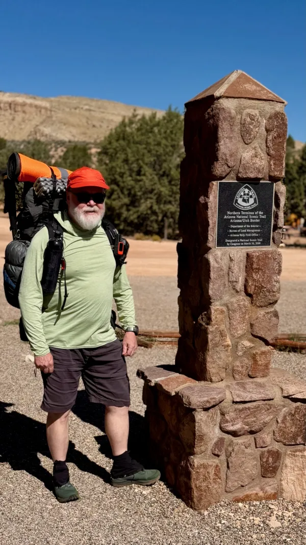
Driving to the trailhead took a little more than an hour. The last 10 miles were traveled on a rough gravel road to Stateline Campground, a Bureau of Land Management campground on the Utah side of the state line. Tom, my driver, dropped me off shortly after 11 a.m.
Just before he left, I asked Tom to take a picture of me at a stone monument marking the start of the AZT.

The text of a poem mounted on a monument
Mounted on the southern side of the monument was a bronze tablet with a poem. The last two stanzas read:
The aches and pains will fade away
You'll feel renewed and whole
You'll never be the same again
With Arizona in your soul.
Along the Arizona Trail
A reverence and peace you'll know
Through deserts, canyons and mountains
From Utah to Old Mexico.
These words seemed glowingly optimistic for a dusty trail that climbs 9,000-foot mountains and crosses scorching deserts. Having Arizona "in my soul" might be nice, but right now, I would be satisfied just getting to the border of Mexico. That was 800 long miles away.
The poem was credited to Dale E. Shewalter, known as the "Father of the Arizona Trail." He didn't come up with the idea of a trail running the length of the state, but he deserves credit for being its chief architect and guiding spirit.
Shewalter, a Flagstaff schoolteacher, began promoting the idea of the Arizona Trail in the 1970s. In the mid-1980s, he walked the entire distance to scout locations for a footpath. The Arizona Trail was formally designated as a National Scenic Trail in 2009. It was completed in 2011, a year after Shewalter died.

Big Dog and his friend at the end of their hike
Shortly after I began walking south, I passed a picnic shelter where two men were resting in the shade. They told me they had just completed their hike. One had the trail name Big Dog, and said he started hiking north from the Mexican border last spring before getting off the trail in Flagstaff.
Big Dog convinced his friend to help him finish the trail going north from Flagstaff this fall. Now they were waiting for a ride to pick them up.
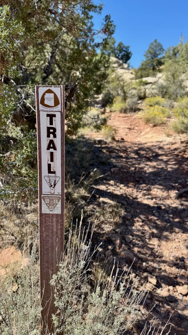
A trail marker with an AZT logo
Compared to the start of the Continental Divide Trail, the route of this desert trail was much easier to follow. The footpath was well defined and occasionally marked with a fiberglass signpost.
The temperature was in the mid-70s with a light breeze when I started. That was much more pleasant than I expected. However, the conditions would soon change.

The trail cuts a path through broom snakeweed
Almost right away, the trail began to climb a slope to the Kaibab Plateau. I had not anticipated so much climbing so soon. During my hike planning, I looked at the map but didn't pay much attention to the elevation changes. I didn't realize until now that the trail would climb 1,200 feet in the first three miles.
This was open, erosional terrain, an arid desert with sparse plantlife, and I expected that. After passing through a grove of short and twisted Utah juniper trees, the landscape shifted to sagebrush and broom snakeweed.

broom snakeweed
Small, yellow flowers densely covered the broom snakeweed plants. The abundance of flowers this time of year provides a much-needed source of nectar for pollinators like butterflies and moths. The insects use this native plant to survive harsh winter conditions or for fuel in their migration.

whipple cholla
On the climb, I also began to see small thickets of cholla (pronounced "choy-ah"), a hardy cactus that survives extreme climates. Some varieties have yellow or red flowers.
I knew to stay away from this cactus because there were many of them on the CDT in New Mexico. I remembered it has many sharp spines that can latch onto your skin.

Looking down at a dark ridge
I'm sure the exertion of climbing to the plateau contributed to this, but I was feeling the effects of the heat. I had only been on the trail for an hour, and already the temperature was pushing into the 90s. My trekking poles and sun umbrella were stowed in my pack when I started hiking, but now I needed them.
Until I stopped and looked back in the direction I had come, I hadn't noticed a steep, eroded ridge nearby. The soil was a darker red than the surrounding sandstone, indicating it was rich in hematite (red iron oxide).
This ridge was part of a geologic formation called the Vermilion Cliffs, which are known as the second "step" up in the Grand Staircase's five steps of the Colorado Plateau.

Dead trees on the climb to the Kaibab Plateau
As the climb continued, the slope transitioned to mostly bunchgrass. Dotting the slope were the blackened skeletons of burnt juniper trees. The Pine Hollow Fire, which happened in 2020 after a lightning strike, burned more than 11,000 acres in this area.
The grasses have come back from that destructive fire, but it will take decades, perhaps a century or more, before trees grow here again.

Desert globemallow
Besides grasses and a few cacti, desert globemallow was growing on the ridge. It is one of the most drought-tolerant species and has some of the largest flowers found in the desert.
Desert globemallow grows rapidly in the spring, then dies off in the fall and drops seeds. They germinate in the winter to restart a growth cycle.

skyrocket
The trail left the burn area near the top of the three-mile climb. This was the start of the Kaibab Plateau and the western end of North Larkum Canyon. There were trees here, mostly juniper and pinion.
And I saw more wildflowers, including bright red skyrocket, also known as scarlet gilia. I remembered seeing this variety in Northern California when I hiked the Pacific Crest Trail.
Skyrocket plants are generally short-lived, but they can live into fall when weather conditions are favorable.

A fence surrounds a wildlife tank
I arrived at a wildlife tank, the first water source of the day, at 2:20 p.m.
It's worth taking a moment to explain that in the desert, the word "tank" is used for any method of holding water for livestock or wildlife. Tanks can be a large metal container, a shallow pond, or even a tractor tire. And often, these are the only water sources available for hikers.

A concrete pool of water at the wildlife tank
In this case, the tank was a small, concrete pool fed with rainwater collected from a nearby metal roof and stored below it.
This tank was intended only for wildlife. A barbed-wire fence surrounded it to keep out livestock. The feeder's small size and concrete sides made it easy for me to scoop water, which was green and cloudy with algae.
Out here, you can't be picky about your water sources. The next one may be 10 or 20 miles away. In this case, I was fortunate because the next one was just 6.5 miles away.
As I scooped and filtered water, several pinyon jays began to gather in nearby trees. The bluish-grey birds watched and waited impatiently for me to leave.
Pinyon jays travel together in large flocks, and as the number of jays in the trees increased, they began squawking loudly. They told me in no uncertain terms that they didn't want me near their water.
They made me feel guilty for being there, but I had no choice. Now numbering at least three dozen, the birds made their way down to the tank as soon as I left the fenced area.

A wide view with Navajo Mountain in the far distance
I met two hikers in this section, but only talked to them briefly. One was a day hiker, and I'm not sure where he came from because the area was extremely remote with only rugged ranch roads.
The climbing didn't stop, but now it wasn't nearly as steep as the first three miles. The trail gained another 300 feet in the next 3.5 miles.
I looked to the northeast through an opening between trees, back toward the trailhead. Barely visible because it was nearly 70 miles away, a large mountain loomed high on the horizon. It was Navajo Mountain (10,348 feet), rising more than 4,200 feet above the desert floor in Utah.
The mountain is sacred ground to the Navajo people. Climbing it is prohibited.

The trail and surrounding ground is covered in gravel
Though the temperature remained hot, the trail was now flat enough that I should have been able to cruise at a faster pace. I had to make frequent stops, however, because I was tiring quickly.
The gravel under my feet crunched loudly with each step. The trail occasionally crossed an old ranch road. At other times, it crossed or followed a livestock path. I never had a reason to doubt or worry that I might miss a turn. The trail was obvious.

Ankle-twisting rocks
Late in the afternoon, the trail made another climb. This one was difficult, but it was short. It probably felt more strenuous than it was because it was covered in ankle-twisting rocks. Also, I was fatigued from hiking all afternoon in the heat.
The rocks only extended for less than a quarter-mile, however. The trail smoothed out again after that. Soon, I was at Winter Road, where I needed to leave the trail to find the next water source.

A sign at a junction on the Arizona Trail
Getting to the water required making a turn at Old Arizona Road and following it about a half-mile to another dusty dirt ranching road. The last one led past a cow tank to a large, buried water pipe. I passed several cows along the way.

A cow stands guard at a water pipe
According to comments posted in the FarOut guide, the pipe had several access lids, but just one could be opened to reach the water. A cow eyed me suspiciously while I looked for the correct one, but at least it didn't complain like the pinyon jays.
I discovered someone had helpfully written "H2O" on the lid with access to the water. This water was much clearer than what I collected from the wildlife tank, but it still needed to be filtered. There were far too many cows to risk not doing that.

The first campsite of the hike
After collecting enough water for tonight's dinner plus the start of tomorrow, I headed back to Old Arizona Road. I remembered seeing a couple of potential campsites there.
The best site was less than 2/10 of a mile from the trail. I had just arrived there when a hiker stopped by and asked about the water. I explained where to find it, and he left. I expected to see him again when he came back, but I never did.
We were both using headlamps then because the sun had already set. I finished setting up for cowboy camping (sleeping under the stars) and then cooked my dinner.
Today was more strenuous than I thought it would be. The long climb at the start didn't help, but I think the heat was what made me exhausted.
Feeling worn out at the end of the first day isn't unusual, but this time it was a reason for concern. Tomorrow will be a much longer day. I will need to walk 17 miles to reach Jacob Lake. I have a reservation for a motel room.
I don't usually feel a motel stay is necessary at the start of a hike, and I debated making the reservation. Now I knew I would appreciate it tomorrow.
The border of Mexico was now 790 miles away, but I didn't think about that. I was much too tired to think about anything.
It is the night
My body's weak
I'm on the run
No time to sleep
I've got to ride
Ride like the wind
To be free again
And I've got such a long way to go
(Such a long way to go)
To make it to the border of Mexico
So I ride like the wind, ride like the wind
This trail report was published