
Day 153 South Fork Scott River to Tentsite at Mile 1555.9
More from this trailSeasons change and so did I
About 420 miles remain before I finish the PCT. If all goes well, I can finish before the end of October.
This schedule makes some assumptions, however. The most obvious of these is that I must remain healthy and injury-free. The trail's terrain or the weather could also slow me down.
One other assumption is made here, though, and this one comes with a big question mark. To finish this month, I must hike at least 20 miles a day the rest of the way. I have never hiked that much before.
Until Bluejay and I flipped to Ashland after hiking through the Sierra, we mostly hiked between 15 and 18 miles a day. Since then, we've boosted our daily mileage a little but not consistently.
For the whole trail, fewer than a quarter of my days went for distances of more than 20 miles.
Still, it feels like this hiking schedule is doable. I just need to change how I manage my time.
I prefer to arrive at camp before sunset. It's easier to do camp chores like finding the water source and cooking dinner when there is still daylight.
Lately, sunrise has come around 7:15 a.m. and sunset happens around 6:45 p.m. To hike at least 20 miles per day, I'll need to start before sunrise and be prepared to walk in the dark.

A view of mountains in the morning
The weather this morning was chilly but not freezing. A clear sky helped the temperature warm up a little faster than yesterday.
The first 16 miles of the trail today remained in Trinity Alps Wilderness. This is the second-largest wilderness area in California. The PCT stayed near the north boundary as it looped around several glacial cirques.

A view of Craggy Peak and a valley beyond
Starting from last night's campsite, the first 2.4 miles of the trail climbed about 1,100 feet to a ridge. The ridge continued higher, but the trail stayed at roughly the same elevation on a slope. Then after another 1.6 miles, the trail climbed again to an elevation above 7,000 feet.
This ridge was part of the Scott Mountains, named for the river where I camped last night. From a gap on the ridge, I could see north in the direction of a low, wide valley.
The valley's terrain looked very different than where I was walking. The flat land appeared to have farms or ranches. Where I was walking had many trees and was strewn with rocks and small boulders.

A view of Mt. Shasta
From another opening, I could see Mt. Shasta again. This view was a daily occurrence, which is no wonder because of the mountain's high prominence. No nearby mountains came close to Mt. Shasta's height.
The mountain is 14,179 feet high, making it the fifth-highest in California. Mt. Shasta is also the most active volcano in the state. It has erupted about every 300 years for the last 4,000 years. Geologists think the last time it erupted was in 1786.
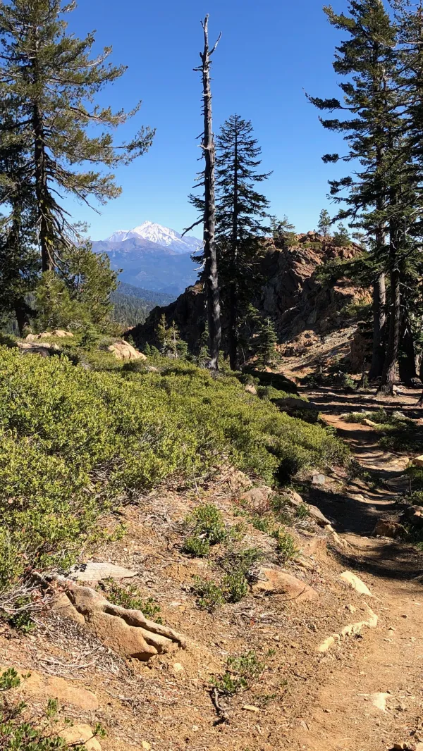
A view of Mt. Shasta from the PCT
The trail wasn’t difficult today, but still, I didn’t feel I was making the progress I expected to make. I wasn't feeling sluggish. I just thought I should be going faster.
I may have been feeling this way because of the pressure I was putting on myself to complete my miles before dark.

Rugged mountains in Trinity Alps Wilderness
There have been few thru-hikers on the trail lately, but today I met five.
The first one was a SOBO hiker who said he was taking a slow-and-easy attitude. Based on where he was on the trail since starting from Washington, this seemed like an accurate assessment. I feared he would be running into difficult weather conditions when he reached the Sierra, but I kept that thought to myself.
I also met four flip-floppers today. Two of them told me their trail names were Grateful Goat and Faithful. They were almost done with their hike because they would complete it when they reached Interstate 5. That was less than 50 miles away.

California Highway 3
After leaving the boundary of Trinity Alps Wilderness, the trail continued another three miles before reaching California Highway 3.
From here, I still had four miles to get to the campsite. I needed less time to do that than I expected. This was a pleasant surprise and showed I was wrong when I thought I was walking slowly.
I satisfied one of my goals by arriving at camp at 6:15 p.m., about 30 minutes before sunset. Because I walked 23.1 miles today, I also achieved the other one.
Tomorrow will give me a chance to do it all over again.
No time for a summer friend
No time for the love you send
Seasons change and so did I
You need not wonder why
You need not wonder why
There's no time left for you
No time left for you
This trail report was published