
Day 46 Stunner Campground to Park Creek
More from this trailLast fair deal in the country, sweet Susie, last fair deal in the town
Top O' and I have been hiking together for two days. There have been a couple of surprises so far.
The first is how beautiful this route has been. I thought I might regret going this way. The elevation was lower and mostly in a valley, so I expected we would be in trees most of the time and have no views. It hasn't been boring at all.
The second unexpected discovery was how similar my hiking style is compared to Top O'. We start the day at about the same time, walk at about the same speed, and are ready to end the day at about the same time.
Some decisions need to be made soon. We will need to work out a plan for where to go next. Should we stay on the Great Divide Alternate? If so, that route will swing wide to the east and out of the mountains. If there is a boring section in Colorado, that is likely it.
Or should we continue north and follow another alternate called the Creede Cutoff? That route is in the mountains and will soon climb above 12,000 feet. It seems likely we would run into a lot of snow.
Our last option is to flip to the Great Divide Basin in Wyoming. There's no snow there, and we could hike south. By the time we get back to Colorado, most of the snow may be melted. We would hike until we reconnect with our footsteps in southern Colorado, then flip again to Wyoming and hike north to Canada. The logistics of this are much more complicated.
Top O' and I intend to take a zero day in Pagosa Springs, where we can work out a plan.

Drying gear in the sun
Frost was on the inside of my tent again this morning. Condensation also made my quilt damp. Top O's gear was wet too, so we decided to stay and dry everything before we left camp. We were fortunate that our site overlooked a wide field, which provided plenty of morning sunlight.
Everything quickly dried, and we left camp at 7:40 a.m.

Top O' walks past Lookout Mountain
We knew from the start that the first eight miles would be a continuous climb. From the campground at 9,870 feet, we would eventually reach 11,700 feet. Snow was certain to be at the top.
The first couple of miles took us past one of the mountains we saw yesterday, Lookout Mountain. We saw more brightly colored rocks with concentrations of iron oxide.

Iron Creek
The road took us across Iron Creek at 9 a.m. Water that had been snow just hours before was gushing from a large pipe under the road. This creek is reported to be excellent for wild trout fishing, but it is also part of the watershed containing arsenic and other poisonous chemical elements.

Snow on Montezuma Peak
The trail then left Iron Creek and crossed over to follow Asiatic Creek. Two features of the surrounding area stood out to me here.
One was the snow I saw on nearby peaks. Montezuma Peak was straight ahead and about 4.5 miles away. It is a 13er (13,150 feet), and the CDT passes within two-tenths of a mile from the summit.
Now I had a better idea of the conditions on that trail. This view didn't sway me into wanting to be up there.
The other feature I noticed was dead trees. They were everywhere. Colorado has been fighting a losing battle against the mountain pine beetle epidemic for several years. An estimate in 2016 said one in every 14 trees was dead as a result of the infestation. The problem has only gotten worse since then.

Signs warning about private property
Several signs appeared a little farther ahead on the road. They sternly announced we were crossing private property. "Stay in car," they warned. I got a small amount of satisfaction thinking I was disobeying the order.

A lake below Asiatic Mine
The signs were located near two lakes in Horsethief Park. The lakes were part of the headwaters of Asiatic Creek. I noticed a pile of gravel and rocks sitting above the first lake. They were the waste rock of Asiatic Mine, which was claimed in 1904. A 1,300-foot shaft was dug for this gold mine.
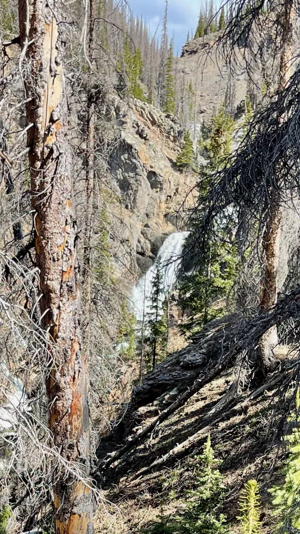
A waterfall on Prospect Creek
The road made two big switchbacks as it climbed away from the lakes and went above 11,000 feet. It then followed Prospect Creek and continued to go up.
Prospect Mountain stood on the other side of the road. There are at least 20 mountains with that name in the U.S., including three in Colorado.
We stopped for a break on the climb to look at a waterfall on the creek. It was at least 200 yards away, but we still got a good view of it through the trees.

Top O' walks across snow at 11,000 feet
Top O' and I found snow piled across the road at 10:45 a.m. We were now approaching the highest elevation of the day and were about to enter Schinzel Flats. The snow was patchy at first but soon became a long stretch of snow that was sometimes deep.

Schinzel Flats
As the name suggests, Schinzel Flats was a broad park that was more-or-less flat. It must be a popular area for snowmobiles because I noticed several tracks in the snow.
As I looked to the west, I could see Long Trek Mountain. The CDT crossed in front of it, so I was looking directly at the route hikers take when they follow the trail instead of the Great Divide Alternate.

Looking toward Elwood Pass
Beyond Schinzel Flats to the east was South Mountain. The site of Summitville was on the other side of that mountain. This was one of the largest gold mining towns in Colorado. The population grew large enough to support 14 saloons and a newspaper.
Prospectors thought the area had been mined out by 1887 and left, leaving Summitville to become a ghost town. The town sprung up briefly a second time in the 1930s when gold mining resumed, then was abandoned again. Mining took off in a big way in 1984 when a large-scale, 550-acre open-pit mine was dug.
By 1992, an ecological disaster in the making had been discovered, with unhealthy levels of acid flowing downstream into communities and agricultural areas. As I noted yesterday, these mountains are naturally acidic and contain oxidized metals. The Summitville mine made those problems worse by exposing the rock to more surface water. If that wasn't bad enough, potassium cyanide used in the mining process was found to be leaking directly into a nearby stream.
The U.S. Environmental Protection Agency filed a cease and desist order against the mining company, which then filed for bankruptcy. That left the EPA's superfund to foot most of the bill for cleaning up the site. The project cost taxpayers $255 million. Colorado will have to continue monitoring the site and manage a water treatment plant, perhaps forever.

Rain clouds around Lookout Mountain
The snow was deeper when I reached the road's highest elevation. I was post-holing so much I had to stop to put on my rain pants. I had been wearing only shorts until now, and the icy snow was slicing into my legs. I lost track of Top O' when I stopped.
I soon wondered if I might also need to put on my rain jacket. Looking toward Lookout Mountain, I could see rain falling around it from large, dark clouds.
A more immediate concern was on my phone, however. When I tried to check my location and see how far I was from Elwood Pass, I couldn't get my phone to work. The screen and my fingers were wet, making normal functions like clicking and zooming in the Guthook app impossible.
In my frustration with my phone, I failed to see my earbuds drop into the snow. I only realized they were missing after I had walked for at least ten minutes. I considered just continuing without them, but then I remembered I had already lost one pair. The thought of losing another pair galled me, so I dropped my pack, turned around, and retraced my footsteps.
After walking two-tenths of a mile, I still hadn't seen the earbuds and decided to give up. I saw them in the snow as I returned to my pack. Somehow, I failed to see them when I first walked by.

Leaving Elwood Pass
I then passed a short trail at Elwood Pass. It was a connector to the CDT. Anyone who might have been tired of post-holing for days on the CDT since Cumbres Pass could bail out here. They could then follow the Elwood Pass Alternate, which was the route Top O' and I began following.
After stopping to put on rain pants and backtracking to retrieve my earbuds, I had fallen well behind Top O'. I was now getting hungry and knew there was no chance of catching Top O' for a while. I stopped for a short lunch break when I found a large rock to sit on.
By now, the road had descended enough to be mostly snow-free again. There were only a few large drifts to walk across, and they soon ended.

Great Divide bicyclists look at a map
Top O' stopped to wait for me where the Elwood Pass Alternate and the Great Divide Alternate split. Some mountain bikers rode up shortly before I arrived. They were riding the Great Divide and had a support truck following them. The bicyclists asked Top O' if it was possible for them to ride to Stunner Campground.
They didn't like what he told them and didn't seem to believe him at first. He said they would have to walk their bikes across at least five miles of snow, and there was no way their truck could get through.

Top O' walks on a road
Top O’ and I left while the bicyclists studied their maps to find another route. The road was now taking us on a long and gradual descent. As we walked together, he told me he met another hiker, whose trail name was Rooster.
Rooster had started from Cumbres Pass on the CDT, and left it at Elwood Pass when he became exhausted by post-holing in the snow. He told Top O' the snow was so bad he could go only walk one mile per hour.
It was a good thing Top O' had waited for me back at the junction. While we walked together, we realized it will be Memorial Day weekend when we arrive in Pagosa Springs tomorrow. Finding a motel could be impossible in that tourist town.
Then I remembered what I did when I was on the PCT and needed to change a motel reservation with no cell service. I sent a text message to Kim from my Garmin InReach, and she fixed the problem for me. I did the same thing this time, and she got to work immediately.
It wasn't long before Kim replied with good news. She found what must have been the last motel room in town. Better still, it looked like a decent place, and for being on a holiday weekend, the rate was reasonable. Now we were set for tomorrow.

A view of Park Creek
We didn't pass any Forest Service campgrounds on this section of road. Of course, no campgrounds appeared on the Guthook app for the last two days, and we stayed at two, so we didn't know for sure what to expect.
The surrounding land all appeared to be part of Rio Grande National Forest, and we presumed we could camp anywhere that was suitable. We only didn't want to camp near the road if we could avoid it.
As we went farther down the road, we began to see people drive by on ATVs. We also began to see camping trailers set up in pull-outs along the road. For one reason or another, we passed up some potential campsites and kept walking. We thought we could be picky until we began to run out of options.
At 5:45 p.m., we found a spot close to Park Creek. It was flat enough for us to pitch our tents. Though it was next to the road, we decided we should set up there anyway because we weren't seeing many options. Besides, there hadn't been much traffic on the road, and most of it was ATVs. We figured no one would drive by after dark.
That calculation was slightly wrong. Two or three cars drove by after dark, but no one bothered us.
There are now just seven miles to go to reach U.S. Highway 160, the road that will take us to Pagosa Springs. Assuming we don't have trouble hitching a ride, we will be able to get to work tomorrow to figure out our next plan of action.
Last fair deal in the country, sweet Susie
Last fair deal in the town
Put your gold money where your love is baby
Before you let my deal go down
This trail report was published