
Day 7 Bright Angel Campground to Grand Canyon South Rim
More from this trailRun, come see what this river has done
Descending to the bottom of the Grand Canyon yesterday took me through several layers of rock. They were laid down over a span of nearly two billion years. The canyon was carved into that rock much later.
To understand how this happened, you need to know about three events. First, the land uplifted to create tall mountains.
Then, a river system formed to the north and would become the Colorado River. Starting at a much higher elevation, the river gained enough power to cut deeply and continuously through those uplifted mountains as it flowed south and west toward the Gulf of Mexico. The water's flow became more powerful as it picked up sediment, working as an abrasive tool to carve the Grand Canyon.
This action alone didn't widen the canyon and make it what we see today. The third event was a series of several geologic actions: erosion, freezing and thawing, and chemical weathering. These caused steep canyon walls to collapse. Tributary streams also formed, and they carved side canyons and undercut some of the walls.
It was hard to fully appreciate all of this geological history yesterday because there was never a time I could see the Colorado River. That changed today as I crossed the river before climbing to the South Rim.
The North Rim is higher and much farther away from the river than the South Rim. Today's hike was going to be shorter and the climb steeper. Yesterday's descent averaged at a rate of 540 feet per mile. I had to climb 755 feet per mile today.
The temperature would again be extremely hot, a couple of degrees warmer than yesterday. To make the day a little more bearable, I hoped an early start would help me reach the rim before the warmest time of day.
Last night remained warm and stuffy. I had difficulty falling asleep. With my alarm set for 4 a.m., I knew I wouldn't get a sufficient amount of sleep. Thankfully, my reservation for tonight at Bright Angel Lodge would help me make up for that.
Just as I woke up this morning, a shooting star flashed across the sky. I took it as a cue to start moving quickly and was soon heading to the trail. The scent of bacon frying at a nearby campsite confirmed I wasn't the only camper intending to make an early start.
The Arizona Trail follows the South Kaibab Trail to the South Rim, and it didn't take long to get to the river where that trail started.

Cables on the Black Bridge glow red because of the light of headlamps
With my headlamp in the red mode, my eyes had better night vision. The stars were bright, and I wanted to see them while also finding my way on the trail.
I crossed the Colorado River on a steel suspension bridge. The South Kaibab Trail uses the Black Bridge, and the Bright Angel Trail crosses on the Silver Bridge. Both are strong enough to handle hikers and mules loaded down with supplies for Phantom Ranch.
As I approached the bridge, the red beam of my headlamp, along with other nearby lights, made the suspension cables appear to glow.
On the other side of the river, several hikers were descending switchbacks on their way down to the river. I knew this because light from their headlamps bounced and swayed. These hikers left the South Rim hours ago. Most would continue hiking today to the North Rim, though a couple that I saw were rangers on their way to work at Phantom Ranch.
I was passed by three hikers descending together who were wearing a coordinated, elaborate light system. The lead hiker had an intensely bright light strapped around her waist. Two of the three hikers didn't just have headlamps; they also wore taillights.
I could see the trail perfectly well, yet they were lighting it up like Times Square.

Looking at the Colorado River from the bridge
There was also a brilliant amount of light coming from an area along the river. Tall floodlights were illuminating a construction site.
Workers were rebuilding the water supply system for the South Rim at night when the temperature was cooler. The Transcanyon Waterline Project was begun in 2023 to replace a pipe system built in the 1960s, which has suffered several breaks in recent years.
The original pipeline drew water from Roaring Springs on the north side of the canyon, which was sent to a pump station at Havasupai Gardens on the south side of the canyon. From there, it was pumped to the top of the South Rim, supplying most of the water needs for the hotels, campgrounds, and other activities of the national park.
The project will provide new pipes, pumping stations, and water treatment plants to ensure much-needed water is available on the South Rim. It will also add helicopter landing pads by the time it is completed in 2026.
The South Kaibab Trail was currently closed because of the project.

The day's first sunlight begins to appear over the canyon
I had climbed about 800 feet by 5:50 a.m. Sunrise was still several minutes away, but there was enough light to see without my headlamp. The air was turning cooler as I went up, but I knew the sun would soon bring the temperature back up.

A mesa stands high in the canyon
The dawn sky made a dramatic impact on the look of the canyon. Every blade of grass, rock, ridge, and mesa appeared to be made of the same muted brown pigment. When I could see the river between mesas, it shimmered in the emerging light.

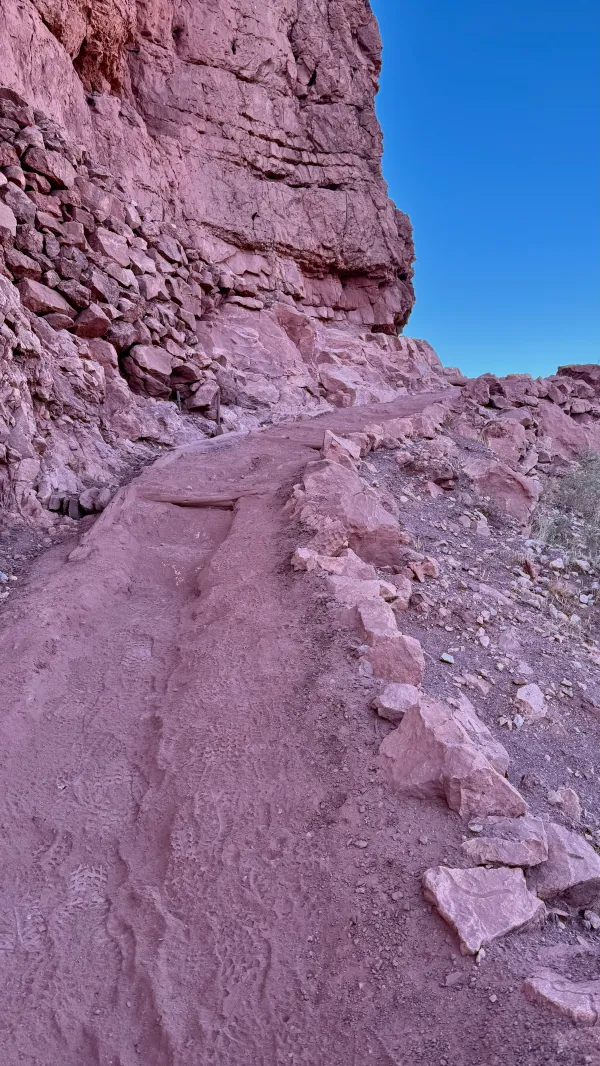
Looking down to see where the trail continues
I stopped several times to take in the view. Each time, the scenery and colors were slightly different as the sun continued to rise. Often, I could see behind me long stretches of the trail I had just climbed. A steady stream of hikers continued to and from the bottom.

Tops of mountains are lit by the morning sun
The landscape's muted monochrome burst into a palette of vivid colors shortly after 6:30 a.m. when the sun's rays lit the tops of buttes on the north side of the canyon. Reds, purples, greens, browns, and beige could be seen among the stack of rock layers. These were the same layers I saw yesterday, only I was now passing through them in reverse order.
It took 5-6 million years for the river and other forces of nature to carve what I saw on my climb.

Sunlight hits the sides of the canyon
By the time I reached a broad, nearly flat part of the canyon, the sun was shining brightly. This was an area called The Tipoff, and was located in the Supai Group layer of rocks.
A large pavilion was built at The Tipoff in 2019 to allow hikers to rest in some shade. When I arrived there at 7 a.m., I had walked 2.7 miles and climbed more than 2,300 feet.
I took a break in the shelter to eat a snack, apply sunscreen, and switch out my empty water bottle with a full one. Two 125-gallon cisterns were located next to the shelter, but I couldn't refill my water bottle because they were empty.

Mules descend the trail into the canyon
By the time I left The Tipoff, the temperature was already several degrees higher. This affected my speed and energy, and I began to sweat profusely.
A team of mules passed me on the way down to Phantom Ranch, carrying supplies for guests, crew, and park rangers. For a fee, the mules will also carry packs for hikers back to the top. I was beginning to see some value in that, but of course, it was too late to use the service.

Looking between mesas to see deep into the canyon
When I stopped for another break about a mile later, I was exhausted. The rock I found in some shade to sit and catch my breath could not have appeared on the trail too soon.
While resting, I met Troy. He was the hiking partner of David, the man I met yesterday, who decided to leave the trail because of severe blisters. We chatted for a bit, but I stayed behind when he left. I needed more time to catch my breath.
Later, a hiker coming down from the top stopped me and asked, "Are you Gravity?" I was startled by this question until he explained he met Troy a few minutes earlier.
The trail makes a steep climb
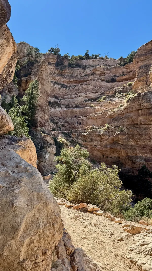
Several sections of steep trail came after The Tipoff, particularly on the approach to a spot called Skeleton Point. It's said that the name became popular because mules sometimes fell to their death on the switchbacks below that spot.
It should be noted that this occurred before improvements were made to the trail. I didn't see any mule skeletons on the way up to Skeleton Point. It was 4,000 feet higher than the river and 4.2 miles from where I started at Bright Angel Campground.
When some shade appeared just before a long stretch of exposed trail, I stopped again for a sit-down break. I also swapped out my water bottles for the last one that was filled.
Usually, one liter would be more than enough for hiking 2.3 miles, which was how far I needed to go to reach the top. That wasn't the case here, with another 1,300 feet of climbing needed to complete the hike in dry heat.

Looking up toward the South Rim
Somewhere between Skeleton Point and Cedar Ridge, I heard a helicopter hovering but never saw it. It was impossible to tell where or even how close it was to me. O'Neill Butte was blocking my view.
Without seeing the helicopter, I couldn't tell if it was a rescue helicopter responding to an emergency, a park helicopter shuttling supplies, or a tourist helicopter flying over the canyon. The latter seemed unlikely, however. The Federal Aviation Administration and the National Park Service enforce strict limits on where and how high planes and helicopters can fly over the canyon, especially where I was hiking.

A view of O'Neill Butte
I learned why a helicopter was flying in the area after I had climbed past O'Neill Butte. Some hikers told me a woman was airlifted after breaking her leg. She had fallen off a steep part of the trail when she failed to get out of the way of the mule team that passed me a while back.
The helicopter had picked up the woman at Cedar Ridge. When I arrived there, I was 5,000 feet from the bottom of the canyon, and I had now hiked 5.7 miles.

Part of the canyon is in shade, the rest is in sunlight
By 10:30 a.m., the sun was high over the canyon, and shade was in short supply. I would have liked to use my umbrella, but there were so many other hikers that I decided against it.
Many of the hikers I passed now were day hikers. Most were only descending as far as Cedar Ridge or a spot called Ooh Ahh Point. The point, which was named for an obvious reason, was slightly less than 800 feet below the rim.
The short distance and the panoramic view that can be seen from there make it an especially popular destination for day hikers. I talked to several of them, including a couple from Florida. They were intrigued to learn about my thru-hike and asked several questions.
The Chimney
The final 500 feet of the climb went straight up a wall, following six tight switchbacks cut into a sheer cliff of Kaibab limestone. This section of the trail has been dubbed "The Chimney" because it almost feels like you're climbing inside one.

Bright Angel Lodge
The climb from the bottom took much longer than I planned, but this shouldn't have been unexpected. I needed several stops along the way to cool down. In the last mile or so, I chatted with several other hikers, which also took time.
After reaching the top at about noon, I considered going to Mather Campground, though I didn't intend to camp there. I knew I could shop there to resupply for the next leg of my hike, and I wasn't sure my room would be ready when I got to Bright Angel Lodge.
I didn't have much of a debate with myself, however, deciding I was too weary for anything but to cool down and eat lunch. The temperature on the South Rim wasn't as warm as the bottom of the canyon, but it was still approaching 90ºF. That was hot enough to convince me to go directly to the hotel.
Free buses shuttled park visitors between the visitor center, lodges, campground, and shopping area. I had to transfer to a second bus before reaching Bright Angel Lodge. It was a route I knew well after my previous trip to the park last January.
I couldn't enter the lobby when I arrived at the hotel, however. A guest had some kind of medical emergency, so the lobby was closed until an ambulance arrived.
Because I had been here several months ago, I was familiar with the grounds and knew a snack bar was on the other side of the lodge. After buying a couple of hot dogs and a lemonade, I sat in some shade until the lobby reopened.
By the time I finished my lunch, I was able to check in. The rest of the day was spent cleaning up, napping, and planning for the next part of my hike. I decided to put off laundry and shopping until tomorrow.
I had been lucky to find a room vacancy at the lodge while I was planning for this hike and knew I'd be grateful for it. The plan could not have worked out any better.

A view from the South Rim
Now, I was done with the hardest part of the Arizona Trail, and I was relieved to know that. Hopefully, I thought, the temperature will not reach the 100s again. I knew I wouldn't have to climb above 9,000 feet again until near the end of the trail.
There was no way to know that the next two weeks would present new challenges. They wouldn't be physical like before, yet they would build each day until they threatened to end my hike just as I was getting my trail legs and hitting my stride.
Run, come see what this river has done
Carved the walls of Grand Canyon
With the colors of the risin' sun
And paint a picture of the Promised Land
In that limestone rock and sand
Run, come see what this river has done
This trail report was published