
Day 22 Kale Gap to Hot Springs
More from this trailI don't do that much talking these days
The morning started cold and blustery, much like yesterday ended. I was slow to get moving.
Shortly after I finally exited my tent, I said hello to a couple of hikers who were walking by. From that point on, I didn't talk to nor even see another hiker until I was less than a mile from Hot Springs.
It was a quiet, lonely hike. I enjoyed every moment.
The sky was clear, and though the sun was shining brightly, it took a couple hours for the day to warm up. Still, I warmed up as soon as I began hiking. That's because the trail began a climb right away. The climb was nearly 1,000 feet up Bluff Mountain. It wasn't a steep climb, and I reached the summit in under two miles.

Blooming trillium next to the trail
Several times on the climb up Bluff Mountain, I passed large patches of blooming trillium.

View from Bluff Mountain
The summit of Bluff Mountain was unremarkable, but there was a view. Generally, there aren't many views from mountains on the AT when the foliage is completely leafed out, but the trees here were starting to do that.
As I did yesterday, I occasionally caught a fragrant whiff of sassafras trees.

Trail switchback at a blue-blazed side trail
Just past the top of the mountain at a point where the trail made a switchback, a short side trail led to a spring. I stopped here to collect and filter water.
When I walked back to rejoin the AT, however, I had a brief moment of confusion. Do I go left or right?
Just as I asked myself that question, I knew I needed to go left. Still, this was a humorous moment that I thought I might want to mention in my blog, so I said to myself, "I should take a photo."
I turned around to walk a few steps back to get a better angle for the photo.

Water bottle hanging from tree
Turning around to take the photo, I was horrified to discover my water collection bladder was still hanging from a tree. I had forgotten to pack it up when I was done filtering water and packed to leave.
This was a lucky break. If I had lost that bladder, I would have trouble getting clean water. The Platypus system I use requires a special connector to attach the filter to the bladder, so I wouldn't be able to use the filter.

Sign at Garenflo Gap
The trail continued on a gradual descent until Garenflo Gap. It intersected there with the Shut-in Trail.
An interesting collection of signs at the gap showed distances to different landmarks, though some were wrong. The length of the trail is different every year because of reroutes. Mileage signs like this one often don't get updated to keep up with the changes.
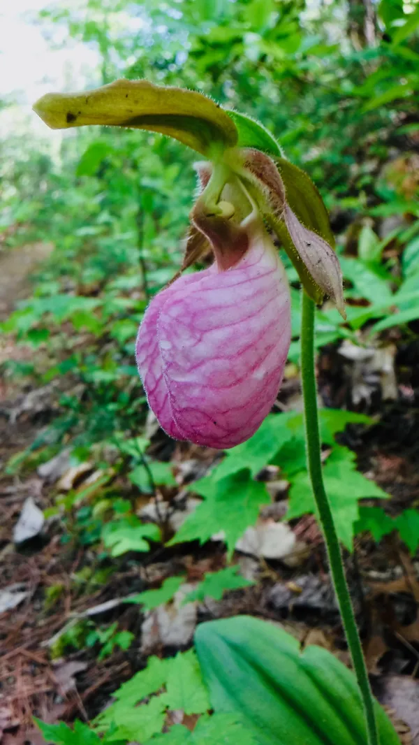
Pink Lady's Slipper
I passed a single pink lady's slipper, which was the first one I had seen so far this year. This wildflower is a member of the orchid family. Though it can be found in a fairly wide range of the eastern U.S., it is somewhat rare in this part of North Carolina.

Two gravestones
Just past Deer Park Shelter was a small clearing adjacent to the trail. In it were two grave markers, one was very old and the other one was newer.

Eva Gragg's headstone
A headstone marking the grave of Eva Gragg was crudely made. She died in 1940. The stone contained the inscription, "Absent, Not Dead."

George W. Gragg's headstone
The headstone for George W. Gragg, presumably Eva's husband, was much newer and was a modern, professionally engraved slab of granite. He died in 1966.
Like Eva's headstone, George's had an inscription implying the deceased was not really dead. His said, "Departed, but not forgotten."

Green tunnel
Leaving the spot known as Gragg Gap, the trail continued a descent for another 1,000 feet. It was now dropping down to the town of Hot Springs. For much of the way the trail had a canopy of rhododendron and mountain laurel.

Bronze tablet near Hot Springs
At the bottom of the mountain, where the trail entered Hot Springs, I found a bronze tablet mounted on a rock. It was placed there by the Carolina Mountain Club to recognize the first fifty years of the trail. The organization maintains the AT and a long section through North Carolina.
When I reached this point at 3:30 p.m., I still wasn't sure where I was going to stay tonight in town. There were a number of options, including a couple of hostels, but so far, I hadn't spent much time thinking about where I might go.
My first thought was Laughing Heart Hostel, which was only a short distance from the tablet, so I decided to walk there first and check it out.

Laughing Heart Hostel
As soon as I reached the building, I saw One Pole. He told me he was staying there and that it was a nice place. He introduced me to the manager.
I asked if there were any single rooms available. One room had a double bed that normally rents for $40, but the manager said I could have it for $35. The price included a shower, which I took advantage of right away.

Laughing Heart Lodge
Also on the Laughing Heart grounds was a large lodge building. It was built in 1892 as a home. From 1954 to 2012, the building was operated as a Jesuit retreat center. The lodge is still used as a retreat center, as well as a bed and breakfast.
Though it was a little early for dinner, I was hungry. One Pole was agreeable to go with me, and we walked a few blocks down to Spring Creek Tavern.
One Pole told me he planned to take a zero day in Hot Springs tomorrow, so he would not be heading back to the trail when I did in the morning.
Well I've been out walking
I don't do that much talking these days, these days
These days I seem to think a lot
About the things that I forgot to do
And all the times I had the chance to
This trail report was published