
Day 26 near CCC Pavilion to Commissary Hill
More from this trailEvery day is a winding road
My hike of the Appalachian High Route has taken many unexpected turns. It's been that way every day, including today.
The sections of the Appalachian Trail and the Mountains-to-Sea Trail I've walked have gone over some of the highest mountain peaks in the southeastern part of the U.S. It's been a winding route with many exhausting ups and downs, but I expected that.
I didn't expect needing to make so many changes to what I believed was a well-thought-out hiking plan. Unrealistic expectations, miscalculations, and the weather altered what was supposed to be a three-week thru-hike.
None of that really matters, I suppose. What's important to me is that I stuck to my goal, which was to complete the full 340-mile loop.
Unsurprisingly, I was met with another change in plans today. I didn't hike as far yesterday as I intended. With fading daylight and few options for a campsite, or at least few that I knew about, I stopped two or three miles sooner than I hoped. Now I needed to somehow make up for that.
Under most hiking conditions, a few extra miles wouldn't be a significant problem. When faced with difficult terrain, shorter daylight, and a deadline, they were a concern.
Somehow, I had to reach Commissary Hill by the end of today if I was going to make it to Burnsville tomorrow.
Commissary Hill sits just below Mount Mitchell, and a campsite there is the only one near the mountaintop that's suitable and legal for backcountry camping.

A tent pitched next to a stand of rhododendrons
The temperature and wind conspired last night to make sleeping difficult. My tent was pitched in a slight depression next to a large clump of rhododendrons, where I hoped to be sheltered against wind gusts. It didn't help much.
Though the wind battered my tent for most of the night, I slept reasonably warm after I put on an extra layer of clothing.

Looking across Craggy Gardens and the valley below
The sky was cloudless but slightly hazy this morning. The temperature was still below freezing, and the wind was only a little less gusty. I hadn't realized until I left my campsite that there was a wide view from this spot. I had been focused only on where to put my tent when I arrived there last night.
My campsite was in an area called Craggy Gardens, an area of almost 600 acres.
A visitor's center was located nearby on the Blue Ridge Parkway, but there was no point for me to go there this morning. It was built in the 1950s, and the aging building no longer has working water pipes. I wouldn't be able to refill my water bottles there.

The CCC pavilion at Craggy Gardens
The Mountains-to-Sea Trail crossed the middle of the pavilion that I checked out yesterday before searching for a tent site. It was constructed of hand-split chestnut and oak timbers. The chestnut logs had been salvaged from dead trees killed by a blight that eradicated the species in the U.S. Stone for the base was quarried in the area.
Construction of the pavilion began in 1936. It was just one of several projects undertaken by a crew from a CCC camp located nearby at Bee Tree Gap. The workers also did road grading and slope stabilization for the Blue Ridge Parkway, but work on it was paused at the start of World War II.
Craggy Dome looms ahead
After leaving the shelter, the first two miles crossed a series of short ups and downs. Craggy Dome (6,062 feet) loomed ahead. It is the highest of a range called the Great Craggy Mountains and is the only mountain among them higher than 6,000 feet.
Craggy Dome's peak is covered in a thick tangle of mountain laurel. I know this because I climbed the mountain in 2007 and discovered the summit was difficult to find. There are no views from the top unless you crane your neck above the laurel. Fortunately, the trail doesn't go that way.

Ice ribbons grow from the ground
The temperature remained cold well into the morning because the trail was on the shaded side of the mountains. From time to time, I passed ice ribbons erupting from the frozen ground.
When I found a spring that was still flowing, I stopped to refill my water bottle. The FarOut app showed no water sources for the next 10 miles of the MST, and I was relieved to find this one.
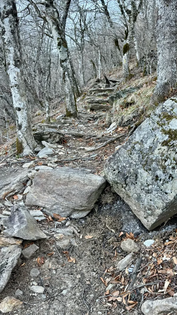
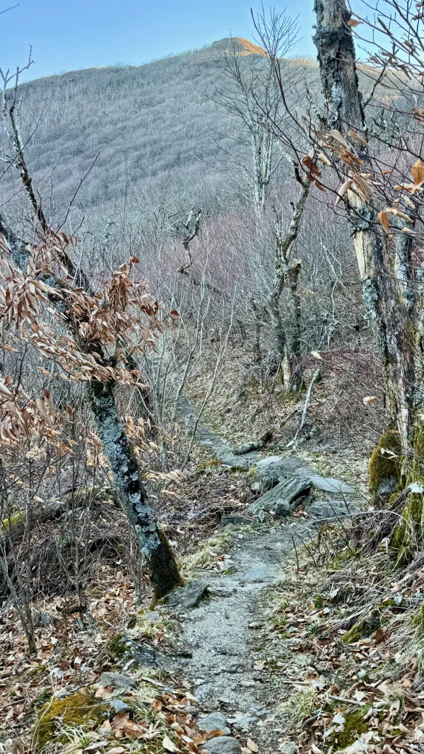
Rocks and roots on the trail
Rocks and roots made the up-and-down path even more taxing. I had to slow down as I negotiated over and around these obstacles.
Getting warm from the climbs, I stopped to take off a layer, but I removed as little as possible. I knew the descents ahead would be cold.

A view of mountains along the Black Mountain Crest ridge
Because it was too early in the spring for leaves to appear on trees at this elevation, I would occasionally get views of a ridge that extended north from Mount Mitchell. The mountains here are called the Black Mountains. I couldn't see Mount Mitchell, but I could see Celo Knob (6,329 feet), the highest peak in my view. It was about 12 miles away.
As I looked in that direction, I knew I would follow the ridge tomorrow when I hiked down from Mount Mitchell and into Burnsville. I also knew that would be the most technical section of the entire Appalachian High Route. Parts of it are so steep that ropes are provided to assist in the climbs and descents.
Between where I stood and Celo Knob were 4,000 acres of land called Big Ivy. The headwaters of the Ivy River, a tributary of the French Broad, flow from here. It's said that this area contains one of the largest patches of old-growth forest in the East.

The MST near Bullhead Gap
That's a remarkable point to make, considering this area was heavily logged in the early 1900s. Champion Fibre Company, which I've mentioned before, was one of many timber companies that operated on the slopes of Craggy Gardens, Big Ivy, and Mount Mitchell. They had a voracious appetite for timber and cut every tree they could. It's a testament of how rugged these mountains are that many trees remained uncut.
I found evidence of the logging in this area as I approached Bullhead Gap. The trail began to follow what was obviously an old road grade, and perhaps had been the bed of railroad tracks.
After the logging companies left the area, this road was used during the surveying and construction of the Blue Ridge Parkway.

Looking back at Craggy Dome
The trail crossed the parkway at Bullhead Gap. I was now on the other side of Craggy Dome. At last, I was out of the shadows of the mountain and walking in warming sunshine.

A view of the Asheville Watershed Conservation Area
From Graybeard Overlook on the parkway, I could look down again into the Asheville Watershed Conservation Area. A range of mountains stood on the other side of the wide valley. Among the peaks was Graybeard Mountain (5,410 feet), a little over four miles away.
When I stopped to enjoy the view, the time was 10:20 a.m. At this point, I had walked only 2.6 miles, but I wasn't yet aware of that because I hadn't looked at the map.

A view from a rock outcropping
I stopped again at 11:25 a.m. when I found a rock outcropping. It was a good spot to sit and eat lunch in warm sunshine.
This is where I checked my mileage, and I was horrified to discover I had only walked four miles in 3.5 hours. I immediately knew if I kept this pace, I wouldn't reach the campsite at Commissary Hill until well after dark. It was important for me to get there because it was the only backpacker campsite near Mount Mitchell. What's more, if I couldn't stay there tonight, my chance of getting to Burnsville tomorrow would be in doubt.
As I thought about this problem, I remembered that I was somewhat familiar with the next section of the MST. I hiked it once in 2006. That was so long ago that my memory of the trail conditions was a little fuzzy. I was unsure if I could make up some lost time in that section, but based on the trail so far today, it seemed unlikely.

The Blue Ridge Parkway at Balsam Gap
Less than a mile past my lunch stop, the trail dropped to Balsam Gap and crossed the parkway. When I stopped at the road to check for cars, I realized it was closed. This and some other parts of the parkway are closed during the winter months.
Knowing now that there would be no traffic, I checked the map, which convinced me to walk the parkway instead of the trail. The mileage would be nearly identical either way, but I could walk on the road much faster. There would be no climbs, rocks, roots, or other obstacles to slow me down. It seemed like I could save as much as two hours by walking on the road.

The Blue Ridge Parkway
There was an added benefit of walking the road, which I didn't consider until I had gone a mile or so. There was more scenery to look at and many views. From when I made a solo day hike to the summit of Blackstock Knob in June 2006, I remembered only one or two spots with a view. The mountaintop was densely covered in trees.
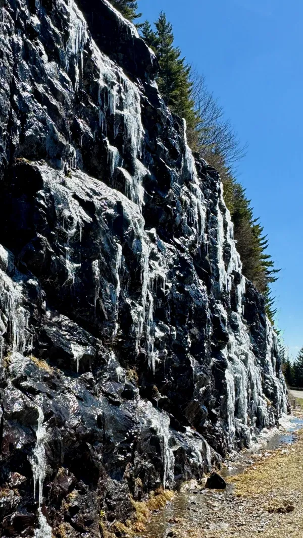
Ice on a rock cut on the Blue Ridge Parkway
Ice that had formed on the parkway's rock cuts was beginning to melt as I walked by.
It felt nice to be in the sun for a long stretch after a chilly morning in the shade.

A traffic barrier on the Blue Ridge Parkway near Mount Mitchell
After a little under 4.5 miles of walking on the parkway, I reached a barricade that stopped vehicles from entering the road. Just beyond it was the entrance to Mount Mitchell State Park.
The road into the park was opened in 1922, seven years after the North Carolina legislature created the state park, the first in the state. Before the road opened, tourists had to travel to the mountaintop by train, which remained after Clifton McClure Lumber Company ceased logging in the area.
I only had to walk on the park road for 6/10th of a mile before rejoining the MST.

The trail on a former railroad bed
Soon, the trail began to follow the path of an old logging railroad bed from the same rail line. When the area was actively logged, the tracks extended all the way to the town of Black Mountain. Clifton McClure Lumber Company only operated in the area for a couple of years before ceasing operation in 1914. By that time, most of the trees surrounding Mount Mitchell had been removed.
When I found a stream crossing the trail, I stopped to refill my water bottles. I knew there was a water source at the campsite, but descriptions of it said it wasn't easy to reach.

Bear boxes at the backcountry campsite at Commissary Hill
I arrived at the backcountry campsite at Commissary Hill at 5:45 p.m. The site was large and mostly flat, and it was equipped with two nearly-new bear boxes. Three men on a weekend backpacking trip were also camped there.
Commissary Hill got its name because that's how this area was used during logging operations. A large commissary building once stood on this site, serving as a supply and storage area for the logging camps higher on Mount Mitchell's slopes.

A tent at Commissary Hill
Though I might have been able to get to the campsite before dark by following the trail, I didn't regret taking an easier route to get here. I couldn't have known for sure how long it would have taken me if I had stayed on the MST.
For that matter, I'm unsure how long it will take me to reach Burnsville tomorrow. All I know about the trail ahead is what I've read. It doesn't appear to be an easy route, and there won't be a road alternate.
I'll be following the Black Mountain Crest Trail, a rocky footpath that will take me steeply up and over some of the area's tallest mountains. There will be more than 3,200 feet of ascent and roughly 6,000 feet of descent.
One reviewer on the AllTrails app said the Black Mountain Crest Trail was "Not for the faint of heart." Another said, "Death March sums it up pretty well."
Certainly, this will be the most strenuous day of the entire Appalachian High Route. I'm grateful I made today a little easier than it would have been otherwise.
This winding road I've been on for 26 days in parts of the last year is coming to an end. It could be a wild ending. It might be arduous. I won't know that until tomorrow.
I hitched a ride with a vending machine repairman
He said he's been down this road more than twice
He was high on intellectualism
I've never been there, but the brochure looks nice
Jump in, let's go
Lay back, enjoy the show
Everybody gets high, everybody gets low
These are the days when anything goes
Every day is a winding road
I get a little bit closer
Every day is a faded sign
I get a little bit closer to feeling fine
This trail report was published