
Day 14 Balsam Gap/Moonshine Creek Campground to Lone Bald
More from this trailI'm going up the country
The best decision for this hike was made yesterday. That's when Polecat and I realized we would be miserable today if we had to walk all the way to the trailhead. The route back was more than two miles on narrow roads and all uphill.
We decided to ask for a ride from the camp hosts at Moonshine Creek Campground, and it worked out great. It's too bad we couldn't have gotten a ride for the first six miles of the trail, a steady climb of about 2,100 feet. Throw in a few short descents and the total elevation we needed to gain was more than 3,200 feet. There was more climbing to go after that.
Mitch was "volunteered" by his wife Barb to drive us. He told us they worked at the campground for three months out of the year. This was the third year they did this.
Polecat and I were packed and ready for our ride by 8:00 this morning, and we were at the trailhead less than 15 minutes later.

Mitch waves as he leaves the trailhead
Mitch refused our offer for gas money when he dropped us off.
As soon as he drove off, I felt the pain I had been anticipating all morning. My backpack was now loaded with four days of food and a two-pound bear canister.
I felt more grateful than ever about deciding to ask for a ride because the extra pounds would not be kind to me for the next several hours.

Polecat starts hiking on the MST
The six-mile climb began almost immediately after we left Balsam Gap. The trail didn't return to the Blue Ridge Parkway but followed a smooth and well-maintained footpath. It was wide and must have been a logging road before the parkway was built. That would have been at least 90 years ago.
There weren't many signs or blazes to mark the route, but it was obvious at first. The footpath was clear, with no other intersecting trails or roads for the first 1.5 miles.
Already, in that short distance, the trail climbed nearly 450 feet. A couple of short, steep parts slowed me down but didn't seem to affect Polecat. He was soon out of my sight.

Polecat walks back after going the wrong way
After the first 1.5 miles, the trail suddenly became confusing. It crossed a stream twice and another trail intersected it. There were no signs or blazes to mark the way.
I stopped at the stream to top off my water bottle and make sure I knew the correct way to go. That's when I saw Polecat for the first time since we left the trailhead. He was hiking toward me, and I knew immediately what happened.
He followed the wrong trail. It descended to the Blue Ridge Parkway, and he realized his mistake when he saw the road.
Seeing how easy it was to make the wrong turn here, I didn't give him a hard time about it. Not much, anyway.

The trail makes a steep climb
There were plenty more steep sections after we left the stream, and again, Polecat soon left me behind. He complained about the added weight of his food and bear canister as much as I did, but it didn't appear to slow him down like it did me.
The trail occasionally passed through dense thickets of rhododendrons and mountain laurel. There weren't many views along this part of the hike.

American cancer root
A lot of American cancer root grew where the rhododendrons and mountain laurel gave way to oak trees. This parasitic plant attaches to the roots of oak and beech trees. It is never green because it doesn't have chlorophyll in it.
Despite being a parasitic plant, American cancer root does not cause any apparent harm to its host tree. It's also known as bear corn.

The trail climbs above a Blue Ridge Parkway tunnel
By late morning, I began to hope I was near the end of the long climb. Unfortunately, after checking the map, I discovered I was still a couple of miles from the top.
I had only walked four miles so far today. The added weight had taken a shocking toll on my speed. I knew I needed to pick up my pace, but I wasn't sure how.
When I stopped to look at the map, I discovered I was standing above the Blue Ridge Parkway. I don't mean I was on a slope overlooking it. The road was 200 feet directly below my feet. It passed through a tunnel, and the trail crossed over the top.
The road was far enough below me that I didn't realize the tunnel was there until I looked at the map.

Sunlight filters through thin clouds
A slight overcast began to fill the sky starting around noon. It didn't mask the sun, but I hoped the cloud layer would keep the temperature from rising. The climb was making me sweat.
My hiking speed was a concern because my son Logan planned to join us late tomorrow. We'd worked out a spot for him to meet us, and I wanted to make sure we got there on time.

A view of a rock quarry near Waynesville, N.C.
There were still many trees blocking out views on the climb, but as I got closer to 5,000 feet in elevation, most of the trees had not yet budded out. This opened small peeks of a valley that extended south from the city of Waynesville.
A large rock quarry caught my attention through one of these openings. It cut a large gash in the mountainside. I later learned it was operated by Harrison Construction.
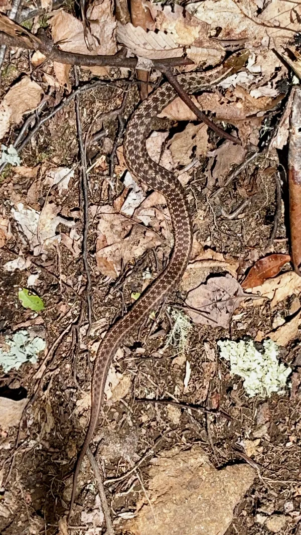
Garter snake
I couldn't keep my attention on the sky or distant sights for long, however. Otherwise, I might have stepped on a large garter snake. It didn't show much concern for my presence, and I knew it wasn't dangerous, so we left each other alone.

Water trickles from a spring
I discovered a small spring near the end of the six-mile climb. The FarOut app didn't mention it. I was glad to find it because I was running low on water. Barely a trickle flowed from the rocks, and I had to scoop from a small pool to refill my water bottle.
Another unmarked spring appeared a short distance farther.

The MST passes near the top of Wesner Bald
The long climb finally ended near the top of Wesner Bald (not to be confused with Wesser Bald on the Appalachian Trail), and at last, I could pick up my pace.
The trail didn't cross the bald's summit. Though this was the end of the continuous climb, it wasn't the highest I would go today. The next five miles added nearly 1,000 more feet of climbing but included 700 feet of descents.

The trail follows an old farm road
At 4:30 p.m., I found myself walking on an old farm road. This was near the end of the last climb of the day. As often happens late in the afternoon, I found a reserve of energy and finished the climb without difficulty.
The trail did something in this section that hadn't happened since we began following the Blue Ridge Parkway two days ago. It left the parkway boundary and would remain outside it for the next 15 miles. There were even campsites marked on the FarOut app for this section.
Although we had been on parkway land all day, I rarely saw the road from the trail. The trail never crossed it, except for that spot over the tunnel.

The MST crosses a meadow
The highest point of the day, at 5,661 feet above sea level, was where the trail crossed a large, grassy meadow. Though this spot offered the best views of the day, I didn't want to linger long. I still had three miles to go before reaching a couple of the campsites the app showed with waypoints.
When the trail crossed the parkway boundary, it entered Nantahala National Forest.

Polecat waits near Mull Creek
Descending from the meadow, the trail followed a ridge called Long Swag. The parkway wasn't visible here, and if I hadn't looked on a map, I wouldn't have known it was about 400 feet above me at the top of the ridge.
Polecat was waiting for me at Mull Creek. The creek flowed across the trail and was a good spot to refill our water bottles. The timing was right too because it was now 5 p.m. We were ready to start looking for a campsite.

Polecat sits outside his tent
The first one was just six-tenths of a mile away. With plenty of daylight and needing to meet Logan tomorrow, we elected to walk nearly a mile farther to the second campsite. It was on a slope of Lone Bald.
The one we chose was large. There wasn't a lot of level ground, but with only two tents to set up, we found space that worked.
At least we were camping legally this time.
I'm going up the country
Baby, don't you wanna go?
I'm going up the country
Baby, don't you wanna go?
I'm going to some place
Where I've never been before
This trail report was published