
Day 9 Jackson Creek to U.S. Highway 78 (Heflin)
More from this trailWhenever you call me, I'll be there
Today would be another nero (near-zero miles) day. We planned to go into the small town of Heflin, and the road to get there was less than nine miles away. I had already mailed a box of food to a motel in town, and we planned to stay there tonight.
When we reached the trailhead closest to Heflin, we could have walked to town by following a 3.7-mile spur trail, but we intended to get a ride if possible. Like nearly all self-respecting thru-hikers, we didn't want to walk any more miles than necessary.
According to what I'd read about Heflin, it is one of the most hiker-friendly places on the Pinhoti Trail. Before the end of the day, we discovered that everything said was true. We found several examples of how citizens, business owners, and town government officials have made Heflin a welcoming trail town.
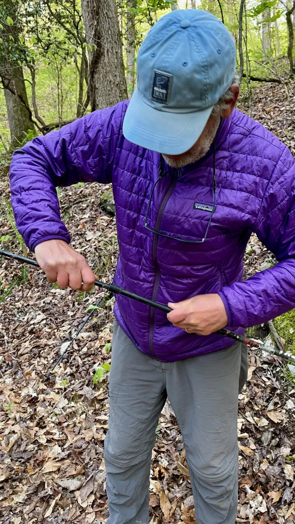
Tengo Hambre tries to fix his trekking pole
Tengo Hambre and I woke up to another chilly morning, though it wasn't as cold as yesterday morning. The temperature was at least five degrees warmer.
Tengo attempted to repair his trekking pole, which snapped in two yesterday afternoon when he fell. A few minutes of twisting, pulling, and trying to jam it together failed to make it usable.

Tengo Hambre walks with one trekking pole
Even though he spent several minutes working on the pole, we still managed to leave camp about 30 minutes earlier than yesterday.
The trail immediately began a roller-coaster pattern, which continued for most of the day. This was a point of irritation for Tengo because he was unable to use both of his trekking poles.

A bridge lies askew over a dry stream bed
There were signs of flooding at the bottom of one of today's many dips along the trail. A wooden footbridge was there, but it was crudely made and completely inadequate for spanning the stream.
Fortunately for us today, there was no flowing water to cross. The ground was a little mushy, but we had no problem crossing the stream bed.

Interstate 20
After walking for two hours, the trail joined State Highway 281, which provided an overpass to cross Interstate 20. Though we couldn’t see it from our vantage point, a sign on the overpass told drivers on the interstate the Pinhoti crossed here.
There was no access to the interstate here and no frontage road. However, if we could have walked east about 3.5 miles from the overpass, we could have reached America's Best Value Inn. That was where we planned to stay tonight. Instead, we still had to go five miles to reach the trailhead to be picked up.

Back on a trail
Tengo failed to see where the trail turned to follow a footpath and kept walking on the road. I was glad I didn’t make the same mistake. I called out to him to stop so we didn’t walk far out of our way like we did on Day 3.
I had plenty of energy when we began the day, but by the time we got to the interstate, I was starting to fade. A quick stop for an energy bar helped me get going again.

A tree cut for Colonial Pipeline
Soon after we turned off the road, the trail crossed a wide gap cut in the trees. The Colonial Pipeline was buried here. The pipeline moves refined oil products from Texas to New York and is the largest pipeline system of its kind in the U.S.
About 2.5 million barrels of fuel pass through the pipeline each day. That's enough to satisfy 45 percent of the fuel needs of the East Coast, including gasoline and diesel fuel for motor vehicles, home heating oil, and jet fuel. The different fuels flow through one pipe in a sequence, which is designed to prevent the fuels from mixing.

A blaze painted on a post
After we walked across the cut for the pipeline, there were a couple of stream crossings and a gap in the trees for another pipeline. Then I saw where a tornado ripped through this area on May 11, 2008. The storm was one of several that left a path of destruction through several states that week.
There wasn't a lot of evidence of the storm to see. The forest was regrowing, and if I hadn't known it had been hit by a tornado, I might have thought it had been clearcut several years ago. The noticeable clue was the trail was marked with blazes painted on poles. They must have been put here after the forest was flattened. Otherwise, the blue blazes would have been painted on trees.
The tornado that hit this part of Alabama left a track of downed trees 2.5 miles long and a quarter mile wide. There was a fortunate side of this, though. There were no casualties and only 468 acres of timber were destroyed. In all, more than 120 tornadoes and other severe storms hit that week in 2008, killing 28 people.

A cave purported to be used by Indians
Then the trail crossed State Road 281 again. Besides being the same road we followed to walk over the interstate highway, it was also the road we crossed at Adams Gap two days ago. This was the road sometimes known as the Skyway Motorway.
A short distance past the road was a cave. It wasn't deep, but it was supposedly used by Native Americans. I didn't know this while we were there, but it's said that what appears to be a grinding bowl is carved into the rocks inside.

A tree cut for a natural gas pipeline
A mile or so farther was yet another tree cut for a pipeline. This one is used by Southern Natural Gas Company, which supplies natural gas throughout the southeast.

Two blazes for the Pinhoti Trail on trees
The trail continued its roller-coaster fashion, and again, I was starting to feel a little weary. The time was now well past noon, and I was ready for lunch. I also knew we were almost at the road where we could call for a ride into Heflin, so I didn't stop.

Tengo Hambre sits at the side of a road
One more time, the trail reached State Road 281. Again, the trail used an overpass to go over another highway, This one was U.S. 78 and was where we needed to stop for today.
We knew from comments posted in FarOut that if you call Heflin's city hall, someone will drive here to pick you up. When I called at 12:45 p.m., it seemed that everyone was at lunch. I had to leave a message.
We waited then, unsure if someone would pick us up. Just a few minutes later, I got a call back from a member of the city's staff, Tammy Perry. She said she would meet us shortly, and it wasn't long before she arrived.
Tammy told us a little about Heflin during our ten-minute ride to America's Best Value Inn. When we arrived there, she wouldn't take any money for gas. What’s more, she said she would pick us up at 4:45 p.m. and drive us to a grocery store. She said it was a little too far to walk from the motel, and that was agreeable to us.
I never thought about making a reservation at the motel before we arrived, but it appeared we were lucky to get a room. It looked like ours was the last one available because the annual NASCAR race at Talladega Superspeedway was this weekend. Despite that, the desk clerk honored the motel's usual hiker rate of $75.
The plan to do our shopping at 4:45 gave us plenty of time to get cleaned up and walk to a nearby Mexican restaurant for a late lunch.
We also met a hiker named Israel, who was staying at the motel. For the last week, we had seen his name written in trail register books and guessed he wasn't far ahead of us. Israel said he was making his first attempt at a thru-hike, and he was just starting to get a feel for the ins and outs of thru-hiking.
I told him the Pinhoti Trail seemed like a good trail for doing that.
Tammy picked us up as promised. When we finished our shopping, the grocery store gave us a hiker discount of ten percent off our purchases. Tammy then returned to take us back to the motel.
She also offered to drive us back to the trail tomorrow. We will meet her at 9:30 a.m. and go to the city hall first. Tammy said she likes to introduce hikers to the mayor.
We saw today several examples confirming Heflin's reputation as a hiker-friendly town. And yet there might be more kindness to come. When Tengo mentioned he had broken one of his trekking poles, Tammy told him she would try to find him a replacement by tomorrow.
This is our fork in the road
Love's last episode
There's nowhere to go, oh no
You made your choice, now it's up to me
To bow out gracefully
Though you hold the key, but baby
Whenever you call me, I'll be there
Whenever you want me, I'll be there
Whenever you need me, I'll be there
I'll be around
This trail report was published