
Day 88 Dayton Gulch to Sheep Gulch
More from this trailWho are you? Who, who? Who, who?
From where OldTimer, Top O', and I had stopped last night, the distance to the village of Twin Lakes was short and all downhill. We intended to stop there this morning, but only for a few hours.
Much like our stop in Leadville the day before yesterday, this was an opportunity to make a quick stop and get back on the trail. The short stay would help us keep up our daily mileage. That's something that suffered for a few days recently because of the weather.
Still, there was no point in getting an early start this morning. The town's only store didn't open until 8:30 a.m. We took advantage of this by sleeping a little longer.
There was another timesaver today. I didn't have to wipe down the inside of my tent. There was no condensation in it when I woke up.

A view of Twin Lakes
Despite attempts to go slowly and leave camp later, we were on the trail by 7:15 a.m. Twin Lakes could be seen through a few breaks in the trees as the trail gradually descended to the village.

Mount Hope, Twin Peaks, and Rinker Peak
Farther down the trail, some 13,000-foot-tall mountains came into view. Mount Hope stood behind Twin Peaks and Rinker Peak. They rose impressively from a flat valley floor.
To the far left of my view was Quail Mountain. I didn't realize it at the time, but I was looking at where we would be climbing later today. The trail would take us up to a pass between Quail Mountain and Mount Hope.

Trail magic from Caveman
Near the bottom of the descent, the trail reached a gravel road that led to the highway into Twin Lakes. I found a cooler of soft drinks there. A note on it said this trail magic was left by a hiker named Caveman.
The final distance to the village was along Colorado Highway 82. In all, the morning hike from our campsite was just 1.8 miles.

Twin Peaks General Store
I arrived at the general store in the middle of the village at 8:15 a.m. As expected, it wasn't open yet, so I looked around and found an outlet to charge my battery. This was a chance to grab an outlet before a lot of hikers showed up.
The village is designated as a national historic district. During the mining boom in the late 1800s, wealthy Leadville residents built summer homes in this area.
A resort called the Interlaken Hotel also operated near here until the early 1900s, when mining operations faded and the area lost its tourism appeal. Some portions of the hotel have been restored, though they are not used today for guest accommodations.
Most of the village buildings had to be moved to their present locations in 1962 when a dam was constructed to increase the size of the lakes.

The cop is a dummy
A county sheriff's car was parked nearby. I didn't think much of it when I first saw it. To kill some time, I wandered around and happened to walk near the car. That's when I noticed a mannequin wearing a sheriff's deputy uniform was sitting inside.
When the store opened, I returned there to pick up a resupply box my wife had sent me. I could have bought all I needed in Leadville, but then I would have had to carry seven days of food instead of five. Those two extra days' worth would have made my pack much heavier.
I also bought a cup of coffee and a few snack items. The store owners didn't charge hikers to accept and hold resupply boxes and this was a way to thank them.

Hikers at Twin Lakes
An area had been set aside for hikers, and by mid-morning, it was filled with about a dozen. Nearly all were hiking the Colorado Trail. One of the hikers was Caveman, who left the trail magic cooler.
I joined them there while I sorted and repacked the food from my resupply box.
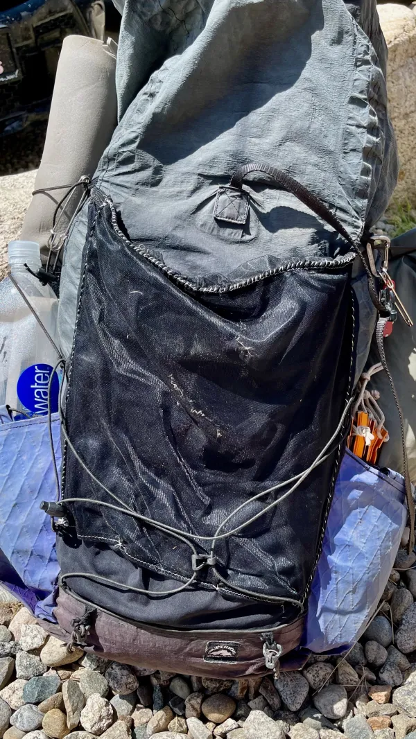
Gravity's pack after being repaired
The mesh outer pocket of my pack was starting to become badly tattered. The problem started when I backed into a barbed-wire fence at the 700-mile point of the PCT. More snags happened later, and larger holes were opening by the time I reached Chama. I attempted to sew the holes shut there using dental floss, but new holes kept opening after that.
In an attempt to fix the pocket before it became completely shredded, I asked Kim to cut and hem two pieces of mesh material and include them in my resupply box. While I sat with other hikers, I stitched the new pieces to cover the holes in the pocket. My sewing may not have looked like it was done by a professional, but I hoped it would be good enough to get me to Canada.

A food truck at Twin Lakes
A food truck was parked nearby. OT and Top O' went there to order some lunch when it opened, but I stayed at the store until I finished my sewing. Besides hikers, tourists stopped here to eat, which made for a long wait when I was finally ready to order. I didn't get my food for another 45 minutes.

Leaving Twin Lakes
Just before leaving Twin Lakes at 1:30 p.m., a woman walked up to me while I was gathering up my gear. She said, "Hi, Gravity! It's Sprinkles!" I didn't expect to see her here.
Sprinkles was a hiker I knew, though I had never hiked with her. We appeared together at a couple of programs for would-be thru-hikers, which were presented by my local REI store. The first was after I completed the AT and the second was after I hiked the PCT. The second presentation was in 2020, just a couple of weeks before the outbreak of COVID-19 ended my hopes of hiking the CDT that year.
I only had a short time to catch up with Sprinkles because Top O' and OT were ready to start hiking again. She told me she was taking a break between work and school to hike the Colorado Trail. After a hasty goodbye, I left to catch up to Top O' and OT.
Then I realized I hadn't taken a photo of her to include in my blog. I quickly ran back to the store, but Sprinkles was gone.

Fording a creek
We could have walked along the highway to a bridge, but most hikers take a shortcut from Twin Lakes to reconnect with the CDT. This requires fording over Lake Creek, but it was shallow and not difficult to cross.

Walking across a valley
The trail crossed the flat valley and headed to a gap in the Sawatch Range. Along the way, I was nearly run over by a mountain biker speeding down the trail. This was an infuriating encounter because he should have known hikers were on the trail. OT and Top O' weren't far ahead of me.

Top O' and OldTimer walk ahead
Dark clouds appeared to be forming and building ahead of us. I knew we would be climbing soon and wondered if we would once again find ourselves in a troublesome spot. Would we have to decide it's too risky to go above the treeline, as we have done so many times already?
The time was 2:20 p.m., and that was when storms often form in the mountains.

Rejoining the CDT and CT
Our climb began as soon as we reconnected with the CDT and the CT. The next four miles would take us up nearly 3,200 feet in elevation.

Aspen trees in Willis Gulch
As has been typical where the CT shared the same footpath with the CDT, the trail was well-maintained and well-marked. The climb went first up Willis Gulch, then Little Willis Gulch, following a stream most of the way.

The creek in Willis Gulch
Although the creek was always nearby, it wasn't always accessible. We loaded up with water in Twin Lakes, however, so we didn't need to stop for a refill until just before beginning the steepest part of the climb. That was near the headwaters of the stream.

A clearing in Little Willis Gulch
About three miles into the climb, the trail crossed a park, which was a nice break from the constant climbing. The opening between trees offered another view of the sky, which continued to look dark.

Ruins of a log building in Little Willis Gulch
The ruins of a log building stood on the other end of the park. Logs were so scattered that it was hard to tell exactly where the structure originally stood. Because of the size and location, it seemed likely this was part of a mine, rather than a homesteader's cabin.

Approaching Hope Pass
Hope Pass wasn't quite in view as we reached the treeline, though it was easy to figure out it was just around a slope to the left. That was the slope of Quail Mountain, with Mount Hope on the right.
Quail Mountain nearly became the site of a large ski resort in the 1980s. Investors spent two decades and millions of dollars on a plan for the resort, despite public outcry about the proposal. Its location was one of the state's last undeveloped high country valleys.
A snow study showed the mountain slopes received significantly less snow than nearby, already established resorts. That didn't do the project any favors, and it was finally killed after multiple rejections by local and federal governing bodies.

Looking back from Hope Pass
Continuing the climb, I passed a marmot chewing on wildflowers. Then as I neared the top of the pass, I turned around to take in the view behind me. I could see Twin Lakes, but it was difficult to make out much else.
The sky was hazy. If it were clearer, I could have seen two of the 14ers I saw three days ago on the way to Tennessee Pass, Mount Democrat, and Mount Lincoln.

Looking ahead from Hope Pass
The climb up Hope Pass is a notable feature of the Leadville Trail 100 Run, a long-distance footrace that is competed each year in August. The course is an out-and-back, so runners have to climb and descend from this pass in each direction.
I was satisfied to go up and down just once.
The top of the pass was extremely windy, and I only lingered there long enough to scan the mountains and deep glacial valley ahead.
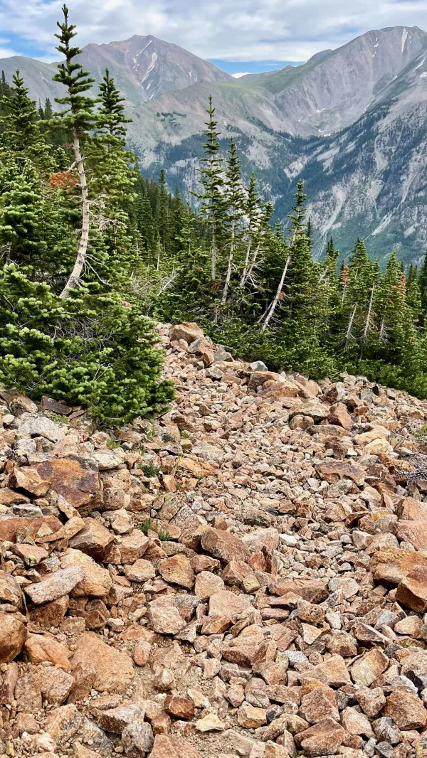
Talus on the trail
The descent from Hope Pass was steep and was sometimes made difficult by talus and loose gravel. I took each step carefully, and couldn't comprehend how someone could run up or down this trail in a race.

Descending in Sheep Gulch
Thankfully, the quality of the trail soon improved as it went down Sheep Gulch. I might have enjoyed it more, but the time was now closing in on 7 p.m., and I mostly focused on looking to see if OT and Top O' had found a spot to camp.

OldTimer
Minutes later, I saw OT. He was walking toward me from the campsite on his way to retrieve some water from a small stream that flowed across the trail. The campsite was just around the corner.
Knowing this, I intended to keep going and do as OT had done, drop my gear and come back for water. Then he turned back to me and motioned in the direction of a tree next to the trail.
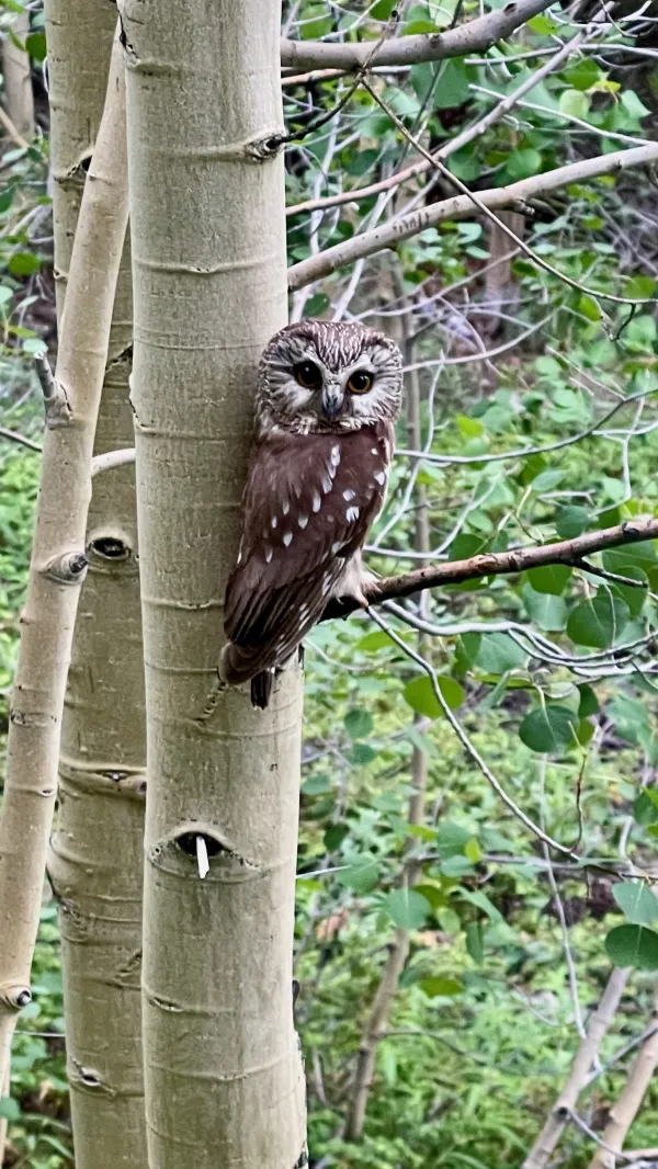
A northern saw-whet owl
He wanted me to see something I had just walked by. It was a northern saw-whet owl. We wondered if this was a juvenile bird, but it wasn't. This particular species is smaller than most owls. They typically only grow to seven or eight inches tall.
The northern saw-whet owl is distinguishable by its large, rounded head with no ear tufts and white feathers in a V-shaped pattern between the eyes.
This owl showed no reaction to our presence, and only stared back as we snapped photos of it.
When I found the campsite, Top O' told me there was a couple camped a short distance away. They had pitched their tent in the middle of the best site. It would have been possible to fit several tents there, but not the way they took up the space. There was another tentsite across the trail from them, which is where they had hung their bear bag. The only remaining site was barely large enough for the three of us, and we had to make do with pitching our tents on slopes among roots.
Our neighbors had broken one of the unwritten rules of backpacking: don't hog the best sites for yourself. We were only mildly irritated with them, however. This was nothing compared to their next unforgivable transgression, but that would come tomorrow morning.
I know there's a place you walked
Where love falls from the trees
My heart is like a broken cup
I only feel right on my knees
I spit out like a sewer hole
Yet still receive your kiss
How can I measure up to anyone now
After such a love as this?
Well, who are you?
Who are you? Who, who? Who, who?
Tell me, who are you?
Who are you? Who, who? Who, who?
This trail report was published