
Day 83 Keystone to Miner's Creek Trail
More from this trailNever got back 'til the Fourth of July
As enjoyable and relaxing as our stay with our trail angels had been, we couldn't stay in their condo forever. Jane and Carter were wonderful hosts, but we had to get back to the trail.
I probably said "Canada isn't going to walk to me" at least once as I was preparing to leave. If I didn't, it was certainly a thought I had. Even the best of times have to be cut short to complete my goal of reaching the border.
I haven't yet completed half of the trail remaining to be hiked in Colorado, though I'm getting close to that.
We enjoyed a wonderful breakfast of eggs, fresh fruit, grilled vegetables, juice, and coffee. While we ate, our hosts told us more about the bike paths we could follow to return to the trail. They showed us a map, and it was surprising to see how many routes there were.
Keystone and the surrounding communities have worked hard to provide residents and visitors with a wide range of recreational opportunities in all seasons. One of the bike paths circles Dillon Reservoir and is 18 miles long.

Leaving Keystone with Jane, Carter, Top O', and OldTimer
We left the condo shortly before 8:30 a.m. Carter and Jane walked with us for the first mile or so to make sure we were heading in the right direction.

Gravity, Jane, Top O', Carter, and OldTimer
Then we said goodbye and thanks to our kind hosts. Our stay with them gave us all that we needed as we returned to the CDT.

Snake River
The first part of our walk along the paved bike path followed the Snake River. This wasn't the same stream as the famous river of the same name that flows through Wyoming and Idaho before joining the Columbia River in Washington. This Snake River is only 15 miles long and empties into Dillon Reservoir.

OldTimer walks on the bike path
We saw many bicyclists as we walked. That was to be expected on this July 4th holiday. We tried to be alert to their presence, and for the most part, we didn't have any trouble sharing the trail.

A view of Dillon Reservoir
After walking for about two hours, the bike path climbed a ridge where we could see Dillon Reservoir. Several sailboats were on the lake near the town of Dillon.
The lake was formed when the construction of a dam was completed in 1963. It serves as a water source for the city of Denver. Water is diverted from here through a tunnel under the mountains that is about 60 miles long. It took 18 years to dig the tunnel.
The town of Dillon was started in 1883 but had to be moved when the lake was filled.

A view of a mountain range ahead
Climbing higher, I could see a range of mountains on the other side of the lake. They were in the direction we were heading. Once we got back on the CDT, we would have to climb that ridge and cross it to the other side.

Walking along the bike path
It was nice to have wide open views as we walked, but they came with a price. There was no shade, and the temperature was rising to the upper-70s.

Walking on Swan Mountain Road
The climb went up to 9,500 feet. From there, the bike path crossed Swan Mountain Road to follow it down on a dedicated bike lane. The road dropped about 500 feet in the next two miles.

A sign says the gas station is open
We reached the bottom of the descent just before noon. The bike path turned to join Colorado Highway 9. When I saw a gas station was just ahead, I thought this would be a perfect place to stop. I was hot, hungry, and thirsty.
Sadly, we discovered the gas station was closed, despite a large banner claiming it was open. Adding to our misery, a soft drink vending machine next to the building was unplugged. It didn't look like it had been operating for years.
There was a table nearby, though, so we sat there and ate lunch.

Top O' and OldTimer
We had a little less than two more miles to go from the gas station to the trailhead. Although a bike path didn't appear on our map, we found one that went parallel with the highway. This allowed us to remain a safe distance from the road.
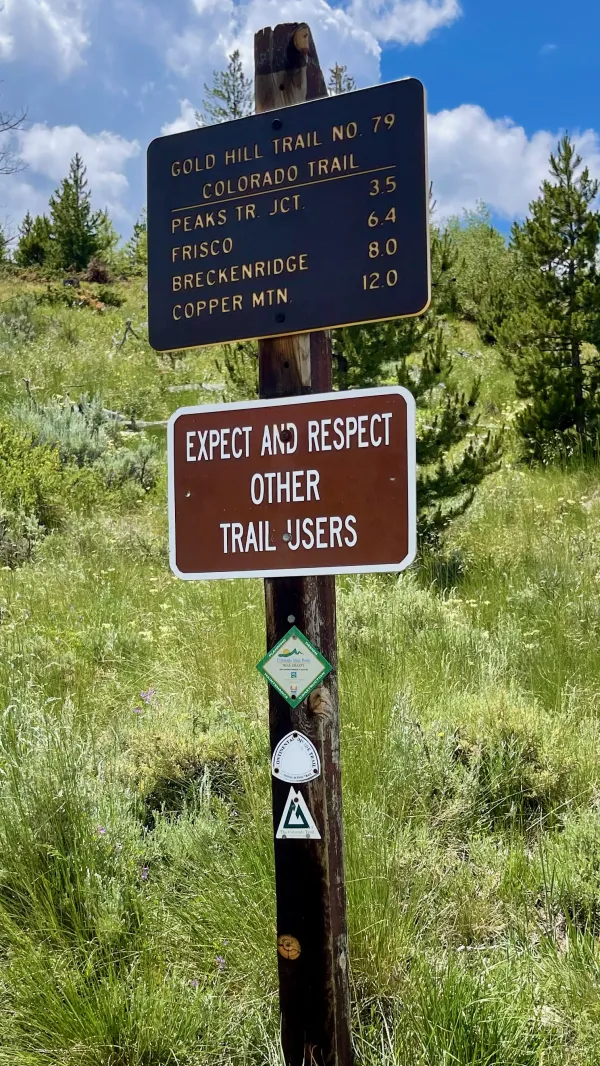
A sign at Gold Hill Trailhead
We finally returned to the CDT after 9.5 miles of walking from Carter and Jane's condo. Adding that to the mileage we walked since leaving the summit of Grays Peak two days ago, we had been off the trail for about 22 miles.
Where we joined the CDT at the Gold Hill Trailhead, we also began walking on the Colorado Trail. We were glad to be finally on this footpath because we had heard many reports that the trail was well-maintained and well-marked.
The CT is 567 miles long, running from Denver to Durango. Most hikers walk it in that direction because Denver is at a lower elevation than most of the trail. This gives them a chance to acclimate to the altitude as they climb to higher elevations.
The CDT and CT share the same footpath for 314 miles.

Looking back toward Dillon Reservoir
The trail immediately began to climb. For much of the next five miles, the terrain was exposed because of the massive killing of trees by the mountain pine beetle.
We met day hikers, mountain bikers, weekend backpackers, and CT hikers on the climb, though no NOBO CDT thru-hikers. It's sometimes easy to pick out novice backpackers in these situations.
One woman we talked to was hiking the CT. I have to give her credit because she had an upbeat attitude when she was obviously struggling. She was carrying a gigantic pack, one of the largest I've seen on any hiker.
When I noticed a full roll of duct tape dangling from the outside of her pack by a large carabiner, I wondered what was in the pack. Did she filled it so full that she didn’t have room for the tape?
I didn't say anything to her about her pack, though I wanted to point out she was breaking three of my backpacking rules.
- Never carry anything strapped to the outside of a pack that could snag on a tree branch.
- Never carry a full quantity of duct tape or other consumables.
- Never carry a pack larger than you are.
In case you were unsure, the last one is the most important of all.

Looking through a clearcut forest
Large swaths of land had been cleared. This didn't appear to be a timber harvest, though. It looked to me like the trees had been cut after being killed by pine beetles. The felled trees were still lying on the ground.
Between the few trees that remained standing, I could see the same ridge I saw earlier, the one we will have to climb. The trail will take us along the side of the ridge before going over the top to the left of my view.
Most of the ascent will happen tomorrow, though we had plenty of climbing to do today. After leaving the trailhead at Highway 9, the trail went up 1,100 feet in three miles. Then after dropping 325 feet in .8 miles, the climb continued, going up 600 feet in the next 1.7 miles.

Walking along a cleared section of forest
We continued through a mix of dead trees and live ones until we reached the junction of Miner's Creek Trail. With the creek and some flat land near here, we decided this was a good spot to camp.
A CT thru-hiker named Junkcart arrived while we were eating dinner. He stopped to join us, but then continued walking to add a few more miles before dark.
One notable thing about today was the weather. Though warm, there were no late afternoon thunderstorms. We were able to hike as far as we wanted to, and only stopped where we did for the convenience of flat ground and a water source.
We also knew of only one place ahead to camp before hitting the treeline, and it was reported to be only big enough for one tent. That's probably where Junkcart will stop tonight.
Asked a fellow for fifteen cents
Seen the fellow, he jumped the fence
He jumped so high he touched the sky
Never got back 'til the Fourth of July
Walkin' the dog
Just walkin' the dog
If you don't know how to do it
I'll show you how to walk the dog
This trail report was published