
Day 61 Deep Gulch to McCormick Peak
More from this trailTonight the bottle let me down
True to the location's name, the spot where we camped was in a deep gulch. I thought moisture would settle in there overnight, and I would wake up with condensation on the walls of my tent. The grass surrounding where Top O' and I camped and the nearby stream seemed like a prescription for wetness to collect inside.
Being out of the wind didn't prevent the condensation, so I don't know why my tent was mostly dry this morning. I'm not complaining.
Today was a day of transition. Top O' and I were leaving the bone-dry, barren landscape of the Great Divide Basin and returning to forests and streams. The dry expanses of sagebrush would become mountains with trees and snow.
We haven't seen the last of the basin, though. After completing our hike south through Colorado, we will need to return to where we started near Sweetwater Station. From there, we'll begin walking north to the Canadian border.

Top O' walks ahead on Sage Creek Road
We had just a half-mile more of walking on Sage Creek Road to finish the stretch we started yesterday morning. I was glad to leave the road.
The trail turned to a gravel road and began to follow the side of a ridge. A CDT emblem had been mounted on a fence post at the junction to mark the turn. Seeing this was unexpected. It was the first trail marker I'd seen in the last two days.
Compared to the AT and PCT, the trail blazes have been hit and miss.

Top O' walks ahead on a gravel road
As soon as we turned onto the gravel road, we began to see changes in the terrain ahead. The topography was becoming hillier. We could see mountains that we would be climbing later in the day. They appeared faintly through a hazy sky.
The haze was more noticeable today than yesterday. Although I have presumed dust swirled up by the wind had caused this, I also wondered if this was smoke from a distant wildfire. Fires are a constant concern on this trail and the PCT.

Old machinery sits rusting in a field
We didn't get far down the gravel road before making a mistake. The road continued ahead and we followed it. We didn't take a turn where the trail started a climb up the ridge. Once we realized this, we decided to continue on the road because the map showed it would reconnect with the trail just ahead.
The road took us past some old machinery that must have been sitting there and rusting for decades. One was a tractor, and the other appeared to be used to construct a barbed-wire fence.

The trail is difficult to see among grass and sagebrush
The farther we walked on the road, the more we realized our mistake. The direction we were going didn't seem to match what the map showed, so we began looking for a way to get back to the trail. We thought we might have to bushwhack our way there, but eventually, we found an unmapped road to take us to the CDT. In all, we walked farther than if we had stayed on the trail.
When we found the trail, it was a faint path across a grassy hill. It was indistinguishable from a cow track.
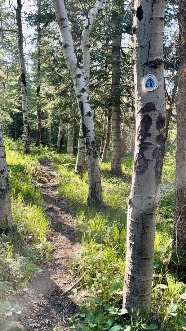
Entering a stand of aspen trees
When we finally began walking among some aspens, I instantly felt a change in my mood. It was like becoming surrounded by old friends after being separated for several days.

Looking ahead from a barren ridge
The trail left the stand of trees as it climbed a ridge. Once again, I was surprised to find a cell signal this far from a town. Top O' kept walking while I stopped to exchange some text messages. I sent one to Kim to let her know I was still alive and replied to one from Sunshine. He said he was in Rawlins, about two days behind us, and wanted information about water availability.
As I looked ahead from the mostly-bare ridge, I now got a better view of the mountains we would soon begin to climb. I could see pockets of snow, but at least the peaks weren't completely capped in it.

Richardson's geraniums
Later in the morning, I saw some wildflowers I didn't recall seeing before. They were Richardson's geraniums, and had light purple petals with dark purple veining.

A sign warns of logging operations
I hoped the trail would soon return me to trees when it descended from the ridge. What I saw instead was disheartening. The forest had been butchered.
Signs were posted to warn that logging operations were underway here, but they were unnecessary. It was obvious what was going on.
Unfortunately, the work was done without regard for the trail. The footpath was covered by fallen tree debris, making the route an obstacle course.

Dead trees lying across the trail
Past where the logging area ended, the trail wasn't in much better condition. Loggers hadn't yet worked in that stand of trees, and many dead ones were lying across the trail.
Mountain pine beetles had killed these trees. Seeing so many dead and fallen trees, I realized the logging effort was to clear the forest and allow for it to regrow more quickly.

A bare ridge with cairns to mark the way
After completing the obstacle course, I began a steep climb to another barren ridge. Some cairns appeared in intervals across the way. The stacks of rocks were helpful because the footpath was barely visible in the stubby grass.

A prong-horned antelope
A lone prong-horned antelope warily watched as I descended from the ridge. It scampered away when I got too close for comfort.
Top O' was waiting for me at the bottom of the ridge. He had stopped for lunch.

A sign for the trail is mounted crooked on a post
After we finished eating, the trail took us to another forested section. At the edge of the stand of trees, a trail sign stood on a wooden post. It was mounted crooked, and I wondered if this was intentional. The sign pointed up toward McCormick Peak, and to be sure, that was the direction we were heading.

Top O' walks through trees
There were more dead trees in this section of the trail, though we had long stretches with no blowdowns. Stepping over or walking around each tree slowed us down, and I grew weary of the extra effort.

Globe flowers
We arrived at Jack Creek at 4:45 p.m. We stopped to collect water here because we expected it was our last water source until we reached the road into Encampment tomorrow. It was good, clear, and cold, with no evidence of cow flavor enhancements.
Globe flowers thrived in the wet ground where the stream overflowed its banks. This water was snowmelt, and there was still plenty of snow ahead that hadn't yet melted.
I collected three liters of water from the creek. I filled the two one-liter Smartwater bottles I usually carry on the trail. For the third liter, I filled the squeeze bottle that came with my BeFree filter.

Top O' walks around snow
Soon after we left the creek, snow became a second impediment besides the blowdowns to our climb up the mountain. We now had to trudge over or around large piles of granular snow.

More blowdowns lie across the trail
Large puddles of snowmelt and mud made the walk even slower. For the next 45 minutes, the footpath alternated between dry trail, mud and water, snow, downed trees, or a combination of them all.
The route soon connected with a forest service road, which at least made the ascent a little less steep.
I attempted at one spot to walk along the edge of the road to simultaneously avoid crossing a downed tree, walking in snow, and slipping in mud. I was unsuccessful. My right foot slipped on some mud, and I fell into a puddle of snow mush.
Irritated with myself and the sloppy trail, I picked myself up, brushed off what water and mud I could, and continued walking.
About 30 minutes later, I was relieved to discover Top O' had stopped where the road intersected with another road. It was a flat and snow-free spot, and the first we'd seen since leaving the creek. Though the time was just 5:30 p.m., I had no reason to argue when he suggested we camp there.

Tents on a flat spot of snow-free ground
Soon after I set up my tent, I checked my phone and discovered I had cell service. I received a text message from OldTimer, who said he was in Encampment tonight. He added that he got an easy hitch into town, which was good to know. We had wondered how difficult it would be.
While eating my dinner, I realized I hadn't seen my water filter and bottle since I stopped. I quickly looked around my gear but didn't have to look long before I got a sick feeling when I realized what had happened. The bottle and filter slipped out of my pack when I fell in the snow and mud.
Though certain of this, I couldn't remember how far back down the trail that happened. At any rate, I decided it was worth the effort to retrieve them. I didn't want to go for several days before I could buy another filter. Besides, I needed the water in the bottle tomorrow.
There was still enough daylight to go back, and I figured the bottle shouldn't be difficult to find. As an extra step of caution, I grabbed my Garmin InReach Mini before backtracking down the trail.
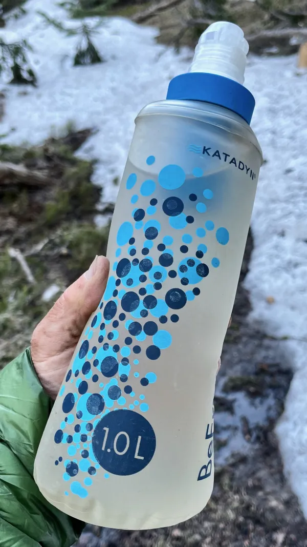
A BeFree water filter and one-liter bottle
As I surmised, I found the water bottle and filter six-tenths of a mile from where we were camped. That was a little farther away than I had hoped, but at least I had them in hand.
Each night I leave the barroom when it's over
Not feeling any pain at closing time
But tonight your memory found me much too sober
I couldn't drink enough to keep you off my mind
Tonight the bottle let me down
And let your memory come around
The one true friend I thought I'd found
Tonight the bottle let me down
This trail report was published