
Day 42 Forest Road 686 to Cumbres Pass
More from this trailCan't hit that border too soon
Last night must have been the coldest night I've had on the trail so far. The temperature dropped to a very frosty upper-20s. I stayed warm and slept well, but I didn't want to leave my quilt in the morning.
Nevertheless, I was in a hurry this morning. There were a couple of reasons for that.
For one, I hoped to get through the snow-covered section that lay ahead before it softened. Once the temperature warmed a little, I would be in for a long morning of post-holing.
My other motivation was the same for any day like today, and by that, I mean it was a nero day. I was heading into Chama with OldTimer, Top O', and No Keys, and we only had a little more than five miles to get there.

The sun rises above a frosty ridge
The sun had barely risen above the ridges when I left our campsite shortly after 6 a.m. The trail crossed the snowless field where we camped last night and made a short climb.

Deep snow on the CDT
The easy path didn't last long. Within 30 minutes, I was following the trail down steeply over snow and blowdowns for the next 1.5 miles.
The snow and blowdowns were as bad as they had been yesterday, but now I also had to deal with a steep descent. It was bad enough that the trail was hard to find, but now, footprints of other hikers appeared to lead everywhere. It was impossible to tell which went the right way and which didn't.

Dirty snow on the CDT
I tried to keep the trail conditions from slowing me too much. As I said, I was in a hurry. That turned out to be unwise.
While trying to hop over one downed tree, the tip of a broken branch snagged the sleeve of my insulated jacket. A two-inch hole tore in the outer fabric.
Now I was more frustrated and annoyed. I didn't want to keep stopping to find my position on the Guthook app, so I began to blindly follow several footprints down the mountain slope. I was trusting whoever made these footprints knew where they were going. If they didn't, I hoped the tracks weren't leading me too far astray.

A snow bridge over Dixie Creek
The footprints brought me to Dixie Creek, where I stopped to check my location. I found myself farther off the trail than expected and now more annoyed. I wasn't getting to the border and Cumbres Pass as quickly as I hoped.
Still, I wasn't that far from the trail and could bushwhack my way to it. I just had to cross the creek first. It was flowing well.
I first looked for a narrow spot where I might be able to leap across. Then I saw a snow bridge about 20 yards to my left.
Crossing a stream on a snow bridge can be a gamble. It might hold your weight and might not. This one was short and seemed solid, so I decided to go for it. It held and I was able to cross without a problem.

A cairn on the CDT
Now to get back on the trail, I had to climb a hill, trusting that my app accurately showed the location of the trail. I thought I was about a half-mile off course, so when I found a trail much before that, I presumed I was on an animal path. I followed it anyway and was soon surprised to see a cairn. I was already back on the CDT.
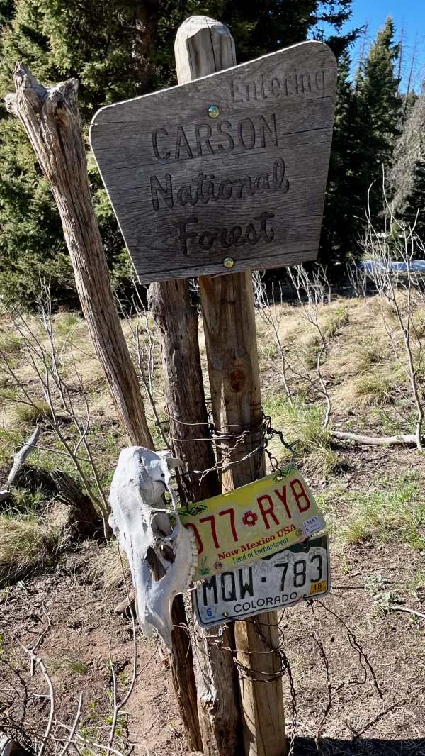
The state line between Colorado and New Mexico on the CDT
Only a half-mile more remained before I reached the state line. It was marked with license plates from Colorado and New Mexico. I paused there only long enough to congratulate myself for making it through my first state on the CDT. Then I hurried down the trail.

A view of a valley and Colorado Highway 17
A view of where I was heading opened a short distance farther, and I was pleased to see most of the snow was gone. A broad valley stretched out below me. It almost looked like a manicured golf course.
Colorado Highway 17 ran through the middle of the valley. That was the road from Cumbres Pass to Chama, New Mexico.

The CDT crosses a long, grassy ridge
The trail to the road followed several long ups and downs but was mostly snow-free. I thought the rest of the way would be easy, but my difficulties weren't completely done.
The trail made a sharp turn at a switchback near the highway. In my haste to make the turn, I slipped on some mud, fell onto some snow, and slid several feet down an embankment. I was unharmed and that move might have been a fun slide if I had done it intentionally.

Cumbres Pass
I reached the highway near Cumbres Pass at 10 a.m. All of the hikers ahead of me had already found rides, so I figured I would quickly find a ride into town. No cars drove by in the first ten minutes I was there, and I realized I was wrong.
The trail crossed the highway at an awkward spot for hitching. It was just below a hill and a curve, which would make it hard for drivers to see me. There also wasn't much of a shoulder to pull over if they did stop.
I decided I needed to walk to the top of the pass to improve my odds of getting picked up. It was only a tenth of a mile away.

Cumbres & Toltec Scenic Railroad tracks at Cumbres Pass
Tracks for the Cumbres & Toltec Scenic Railroad crossed at the gap. A station and other small buildings were nearby. This was a stop for the tourist train that runs out of Chama. The narrow gauge, steam locomotive train runs several times a day in the summer. I was too early this season to catch a ride on a train, though that is possible for hikers to do.
As a matter of fact, I have ridden trains on a couple of previous backpacking trips in Colorado. I rode the Durango & Silverton Narrow Gauge Railroad into Weminuche Wilderness, then flagged down the train after completing the hike to return to Durango.
No cars drove by in the direction of Chama while I stood at Cumbres Pass. There was only an RV and a couple of large trucks. Eventually, though, a car pulled into the parking lot from the other direction. A hiker was dropped off here.
The driver asked me where I was going. When I said, "The Y Motel," he answered, "Why?"
I was about to explain that I thought my friends were there until I realized he was making a joke. Actually, it was only a half-joke. After I got into his car, he said he worked at The Hotel in Chama. His name was Carl.
Carl told me he had just taken No Keys, OldTimer, and Top O' into Chama. Top O' went to The Hotel and the other two went to the Y Motel. This was helpful information. I had texted No Keys earlier, and he told me they went to the Y Motel. I didn't know Top O' hadn't gone with them.
Figuring that No Keys and OldTimer would be sharing a room, I asked Carl to take me to The Hotel. I didn't know for sure Top O' would be willing to share a room with me, but it was my best shot.

The Hotel and Shops, Chama, New Mexico
Top O' wasn't there when we arrived. Instead of sitting around, I decided to go to the post office and pick up my packages. One package was from REI and contained a new sun hoodie I ordered to replace the one I had worn since starting this hike. It was starting to look a little grungy, even by thru-hiker standards. The other one was a box Kim sent me. In it was my replacement water filter, plus food and my microspikes.
After a lot of uncertainty, I didn't ask her to send my ice ax. A lot of hikers were getting them sent here, but I concluded the snow conditions were still too dangerous. I intended to follow an alternate trail north, and I hoped to avoid most of the worst sections.
As I've mentioned, I've hiked in the San Juan Mountains a couple of times before. I would like to hike in them again, but I also prefer to not risk my life doing it.
I told the postal clerk my name and he went to a back room to retrieve the packages. After being gone for several minutes, he returned empty-handed. "What was your name again?" he asked.
The poor guy must have been under a lot of stress these days. The town was filling up with hikers and nearly everyone had at least one box shipped here.
He found my packages after a second search, and I returned to the hotel. Top O' arrived soon afterward. He asked if I wanted to share a room with him, and said he already had one with two beds. This was a relief to me. With so many hikers in town, I wasn't sure until now I had a place to stay. I also didn't know Top O' was expecting I would show up here.
Later, after I had a chance to get cleaned up, Top O' and I walked down the street to find something to eat and check on No Keys and OldTimer at the Y Motel. We weren't in a hurry to complete our town chores. We'll take a zero day tomorrow.
No Keys and OldTimer were on the fence about what they wanted to do next. Top O' was thinking as I was. Neither one of us wanted to wait in Chama for the snow to melt or try to push through the snow. I was pleased when he said he was willing to continue north with me on the alternate that follows a lower elevation route.
I walked 42 days to get through New Mexico. I still have at least 2,000 miles to go to finish the CDT, and it looks now like I have a new hiking partner. I have a feeling the adventure has only just begun.
Out on the edge of the empty highway
Howling at the blood on the moon
Big diesel Mack rolling down my way
Can't hit that border too soon
Running hard out of Muskrat Flats
It was sixty days or double life
Hail at my back like a shotgun blast
High wind chimes in the night
Oh, oh, pride of Cucamonga
Oh, oh, bitter olives in the sun
Oh, oh, I had me some loving
And I done some time
This trail report was published