
Day 34 Corralitos Trail Junction to Chama River Canyon Wilderness
More from this trailGone are the days we stopped to decide where we should go
People who have never attempted a thru-hike often assume the trail gives a lot of time to think. For some hikers, that may be true, but not so much for me. I've found I don't have much time to work out life's issues.
My thoughts are much more limited and basic than that. I tend to walk in one of two mindsets. In one, I'm concentrating on the trail. I want to make sure I'm going in the right direction and don't step on a rock that will twist an ankle. In my other thinking mode, which happens when the trail is easy, I put my brain in neutral and just walk.
In both of these mindsets, I'm also trying to stay aware of my surroundings. I want to notice and appreciate the environment around me. That, of course, is one of the reasons I'm here.
There are times, however, when a pressing problem requires some extra thought. Some details need to be worked out. Such was the case yesterday and today. Zigzag and I still needed to make a plan for our next resupply.
We had several options, and none stood out as an obvious choice. By this morning, we had narrowed them down but still hadn't come to a firm decision. We decided we didn't want to go to Chama or Santa Fe. That left Abiquiú or Española as towns where we could resupply. Also still to be decided was how to get there, by bus or hitchhiking.
COVID-19 has injected complications into our decision-making. We'd prefer not to hitchhike right now for safety reasons. The bus service available to us has eliminated one of its runs and has reduced seating to just four passengers. Advance reservations are required.
We will reach the road into Abiquiú and Española tomorrow, so there won't be much time left to make some decisions.

Snow on the trail
Something fell from the sky last night and pelted my tent, but I don't know if it was snow, rain, frozen rain, or sleet. It fell briefly at around 1:30 a.m., and by the time I crawled out of my tent this morning, everything was dry.
A few small patches of snow remained along the trail when I started walking at 7:15. They disappeared as the trail dropped below 10,000 feet, which happened just 1.5 miles after leaving our campsite.

Blowdowns across the trail
A little farther down the trail, I ran into another section of blowdowns. These were an annoyance like yesterday, but they didn't pose a problem for an extended section of the trail.
When I discovered I had a cell signal, I called the bus service that ran a route between Chama and Española, with a pickup point outside of Ghost Ranch. I wanted to see if there was still a limit of four passengers per route.
I learned there was, and also found out tomorrow's morning run was already full. Two seats were still available for the afternoon pickup. Foolishly, I didn't reserve them for Zigzag and me. I was hesitant to do so because he wasn't nearby to make sure that was okay for him.
I texted Beer Goddess to see if she and Lone Wolf had figured out their plans.
As soon I was out of cell service again, I began to worry I had lost our opportunity to get those seats. For the rest of my way down the long descent, I only thought about how I should have made reservations.
All the extra time I had on the trail for thinking wasn't helping me think more clearly.

Creeping Oregon grape
The trail was mostly wooded in this section of the descent, which made the walk enjoyable and not too warm.
On the way, I passed small clumps of creeping (or trailing) Oregon grape. Their yellow flowers will become blue, edible berries later in the year. The plant grows wild here but is also cultivated for use in gardens in the northwest U.S.
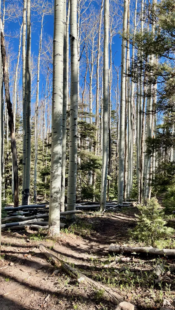
Entering an aspen forest
As the descent continued, the trail left San Pedro Parks Wilderness and passed through a large forest of aspen.

A cow blocks the trail
A small herd of cows blocked my way for a short time. I patiently waited until they saw me and grudgingly cleared a path for me to continue.

A view of the valley ahead
After the trail left the aspen forest, there were fewer trees to block the views ahead. From what I had seen earlier, the sky had been mostly clear. It now looked like that was changing, with a few clouds beginning to move in.

A sign promises trail magic ahead
I reached Cecilia Canyon at 10:15 a.m. This was a narrow drop to a stream and a road. I saw here signs taped to a trail marker announcing trail magic was nearby. The signs also showed yesterday's date, but that didn't deter me from hoping there was still food or drink to be found.
I scouted around a little and saw a tent, but was disappointed to find no one and no trail magic.
After collecting and filtering water from the stream, I made a short climb out of the canyon. The trail went up 140 feet, then resumed its long descent.

Sagebrush in a desert
After walking nearly 11 miles since I started this morning, I reached New Mexico Highway 96. I caught up to Zigzag near here, and we stopped for lunch.
I confessed to him my failure to reserve two seats on the bus. He didn't seem to regret my poor decision-making nearly as much as I did.
We agreed if I was able to get a cell signal again, I should take what bus seats I could get. We also agreed to go to Española instead of Abiquiú.
The bus schedule made tomorrow afternoon a more practical time to go, though it would also be more expensive. Española offered better options for resupplying, but we would have to stay overnight because of the bus schedule. Still, there were motels in town, and we would have time to do our laundry.

A layered sandstone bluff
When I began walking again, the trail crossed an open desert of sagebrush and passed colorful sandstone bluffs. More clouds moved in, but they didn't moderate the temperature much. It was becoming warmer.
The trail continued for about a mile before starting a climb. The exposure to the sun made this section especially hot.
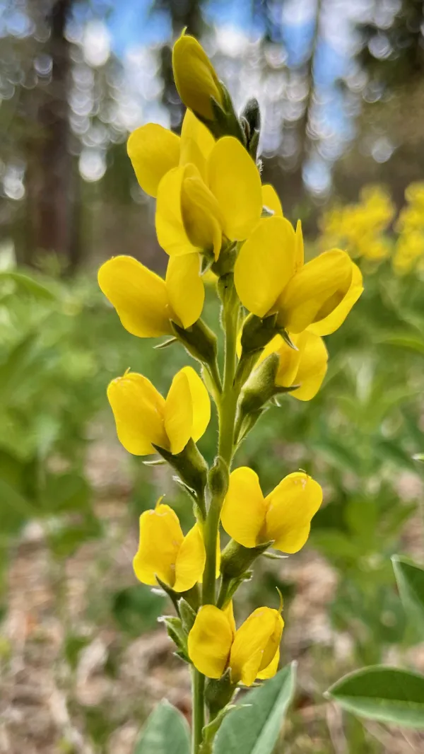
spreadfruit goldenbanner
The climb soon became steeper, but eventually was less open to the sky. Trees reappeared, as did wildflowers. I found some spreadfruit goldenbanner in this section. It is a member of the pea family and tends to grow in shade.

Climbing Mesa del Camino
The trail went up and around Mesa del Camino before cresting near the mesa's high point. When I finished the climb, the time was after 4 p.m. I was unsure if I could get a cell signal there or if the bus company was answering the phone that late in the day. Thankfully, neither worry turned out to be a problem.
Before I called the bus company, I received a reply from Beer Goddess. She said she and Lone Wolf were not going to use their reservations, though they were in No Keys and Lone Wolf's names. She suggested Zigzag and I take the seats and use their names.
When I called, all four seats for tomorrow's afternoon bus run were still available, so I reserved two. We wouldn’t have to pose as someone else and had plenty of time to get to the bus stop at Ghost Ranch.
I wasn't able to reserve seats for a return to Ghost Ranch the next morning, but afternoon seats were available. I didn't hesitate to reserve those.
The bus schedule will make our stay in Española an unplanned zero day. We don't need one for a rest, but we have no choice and don't mind. Zigzag and I often say we want to slow down and not arrive in Colorado too soon. This schedule adds a day to do that.

A cow tank made from a tractor tire
The descent from Mesa del Camino was short but sometimes steep. It ended in an open field and near a cow tank made from a tractor tire. I could see from the field that clouds were becoming thicker. It appeared a storm was forming.
The time was now 5:15 p.m. I decided to collect water now from the cow tank instead of waiting until I reached where we planned to camp. I knew a stream flowed near the campsite, but I wanted to get water early in case the weather turned bad before I got there.

Zigzag in a campsite
After continuing for about three more miles, the trail entered Chama River Canyon Wilderness.
Zigzag was setting up his tent in a small canyon when I arrived. This was about a mile before I thought we would stop, but I had no complaints about the location. We had easy access to water and flat ground for our tents. Better still, stormy weather never came.
The uncertainties of where we would resupply and how we would get there were finally resolved. I was glad that got sorted out before we reached the highway at Ghost Ranch and were forced to hitchhike or wait longer for another bus.
Besides, we're now allowing a little extra time for the snow to melt in Colorado. Will the melting be enough to clear the route through the San Juan Mountains when we get there? From the reports I've seen, I'm beginning to think the answer is no, but I'm still trying to not dwell on it too much.
I'd rather just think about where I'm taking my next step.
Gone are the days we stopped to decide
Where we should go, we just ride
Gone are the broken eyes
We saw through in dreams
Gone, both dream and lie
This trail report was published