
Day 23 Narrows Rim Trail to Interstate 40
More from this trailYou know you bound to wind up dead
I know I will die someday, but I have always presumed my death will not happen while I'm hiking. I don't fear being killed by a wild animal, for instance, because I know those deaths are extremely rare.
A death caused by severe weather or a fall from a great height also seems unlikely. I'm cautious and adjust my hike according to the risks.
That said, I almost died today. It's fair to say I never saw it coming.
The day started well with no portent of death. Zigzag and I chatted with DhammaBum for a few minutes and didn't leave camp until almost 8 a.m.
When we reached the highway, we found a beer among a cache of water. They weren't there when we arrived yesterday. The beer was an IPA, fittingly named Happy Camper. Zigzag said he didn't care for IPAs, so I gladly took it to drink later.

NM 117 enters the Narrows
After returning to State Road 117, we resumed our walk on the narrow edge of asphalt outside the traffic lane. The road didn't have a shoulder, though at least there was room for us to step off when we saw an oncoming car or truck.
Gravel next to the highway was uneven and loose. Walking on it for more than a short distance was difficult. We found it was better to walk along the white line and then step off when a vehicle approached. There weren't many cars and trucks on the road this morning, so we didn't have to do that often.
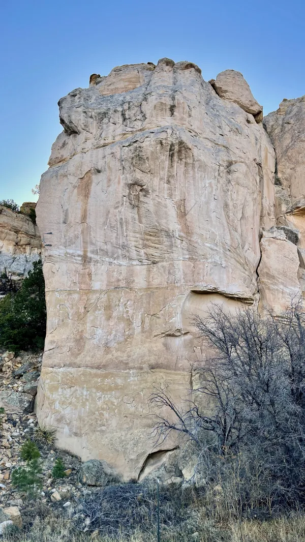
A sandstone bluff
From where we started at the picnic area below our campsite, the highway threaded through a confined strip of land. It ran between the edge of the lava flow from the Zuni-Bandera volcanic field and the base of a sandstone mesa. There was more than one of these "narrows" on this stretch of road.

NM 117 at the Narrows
The bluff to our right stood as high as 500 feet. Until mid-morning, we often walked in shade cast by the mesa wall.

A view of the lava field
The road sometimes rose high enough to where I could see across the lava field to our left. Seeing this bleak and rugged expanse made me glad we didn't have to walk across it.
Between 950 C.E. and 1350 C.E., ancestors of today's Pueblo peoples, also called the Anasazi, constructed communities around this lava field. They found ways to use the hard, dark rock for tools in much of their daily activity.
To help them cross the lava "bad lands," they constructed rock bridges by filling crevices with small rocks. Rocks were also stacked as cairns in the same way hikers use them today for navigation.

Taxilady
After we had been walking on the road for about 90 minutes, a car pulled up next to Zigzag and me. The driver was Taxilady. She stopped to say hello after dropping off Doggone, who was slackpacking the road walk.

La Ventana Natural Arch
By this time, we were near La Ventana Natural Arch, which was 3.8 miles from where we started this morning.
This arch didn't resemble the natural sandstone arches I've seen in places like the Cumberland Mountains of Tennessee, but it was formed in the same way. The soft sandstone was eroded away by wind and water. The difference here was it was formed on the side of a mesa cliff.
It's no wonder this arch was called La Ventana (The Window).

Zigzag and Gravity take a break
Zigzag and I followed a footpath to get a better look at the arch, then returned to a picnic area near the road to take a break. The land surrounding the arch is maintained by the U.S. Bureau of Land Management.
We appreciated the shade provided by a canopy over our picnic table. Along with a snack, I enjoyed drinking the beer we found this morning.

NM 117 enters Acoma Indian Reservation
A short distance from the picnic area at the arch, the road entered Acoma Indian Reservation. The Acoma are a Puebloan tribe. Their reservation covers nearly 600,000 square miles, stretching from here to Albuquerque. It is home to almost half of the 6,000 tribal members.
The highway serves as a border for the reservation, with El Malpais National Monument on the other side of the road.

La Vieja
Farther up the road on the national monument side, a tall rock formation jutted from the ground. It is called La Vieja (The Old Woman).

Los Pilares
More sandstone pillars stood nearby on the reservation side of the road. They are known as Los Pilares (The Pillars).

Zigzag finds a water cache
When we reached where the Cebolla Alternate reconnected with the official CDT route, we found a water cache. It was tucked among some low-hanging juniper trees.
This was our first water source of the day, and we were grateful to have it. Water has been extremely scarce on this part of the trail.

NM 117 passes a large sandstone bluff
Back on the road, we walked by another tall and impressive wall of sandstone. This was also part of the Narrows, and here, the road passed within a few feet of the wall.
After the road curved around the wall, we came to Joe Skeen Campground, a facility managed by the Bureau of Land Management. We arrived there a few minutes before 1 p.m.
Zigzag and I hoped this would be a good spot for lunch, and we were correct. Each of the campsites had a picnic table with a canopy. We were glad to get out of the sun.
During our break, we discovered a note taped to our table. It said the ranger station just up the road was only open Thursday through Sunday. This was alarming news because we had counted on refilling our water bottles there, but today was a Wednesday.

Zigzag enters the drive to the ranger station
The ranger station was about 2.2 miles from the campground. We found a closed gate to the parking lot entrance when we arrived, but we decided to see if there was a spigot or faucet outside the building to get water.

DhammaBum talks to Zigzag
We found DhammaBum was just leaving when we got to the parking lot. He told us where to find a working spigot at the side of the building.
This was fortunate because we still had nearly 10 miles to go for the next opportunity to get water.

An open stretch of NM 117
After we refilled our water bottles and left the ranger station, we continued our walk along NM 117. We passed a road crew that was working on the shoulder of the highway with a road grader and several large dump trucks.
Without any warning, Zigzag and I felt a sudden blast of wind, then saw a blur of motion at our side as a car zoomed past us. The driver had passed one of the dump trucks by entering our lane. For an instant, I thought the car brushed my shirt sleeve as it raced by, though it was more like two feet from where we were walking.
The driver must have been going at least 60 mph. It seemed impossible that he didn't see us in broad daylight and open terrain before he made that reckless move.
The driver was gone before we realized how close we came to being hit. This was one of those moments that takes your breath away. It came close to being my last breath.
Then as if to underscore the stunning moment, I noticed a dead snake flattened on the pavement.
Making me feel worse, I was disappointed to discover I had lost the Joan Jett and the Blackhearts bandana I normally tie on my pack shoulder strap. It was a gift from my PCT and BMT hiking friend Just Awesome.

A warning sign says watch for water
I continued to feel shaken by the incident for several minutes until I had to laugh when I saw a highway sign. It said, "Watch for water." This was so incongruous in the flat desert it felt like a practical joke.

A distant view of Grants and Interstate 40
By 5 p.m., I began to see far in the distance some buildings and a highway. The town of Grants and Interstate 40 were coming into view. We would need another hour of walking to get there.
On the way, we saw Taxilady again. Doggone was with her this time after she picked him up at South Narrows Picnic Area, the spot where we left from this morning.

NM 117 crosses Interstate 40
When Zigzag and I arrived at the interstate highway, we were tired and sore but were still several miles from Grants. The only businesses here were a gas station and a Subway restaurant. We dropped our packs outside and ordered sandwiches and cold drinks.
While we sat outside to eat, we tried to figure out what to do next. This was difficult for us. We felt fried from the sun, the road walk, and our near-death experience.
Part of the problem was we had several options to consider. We could continue walking for another five miles to one of several hotels. The campground where Doggone and Taxilady were staying was also a possibility, but we soon decided a motel was a better choice.
Then we were unable to find an Uber driver in the area. It took a few more frustrating minutes before we remembered Doggone and Taxilady repeatedly told us we could call them anytime we needed help. We did that, and within minutes, Doggone arrived to take us to a hotel.
That was a good way to put a positive note on a difficult day, but it soon got even better. Remembering that Doggone would be walking tomorrow on the same road we walked today, I asked him if he could keep an eye out for my bandana. I told him I thought I probably dropped it near the ranger station, and he agreed to look for it. It was a wild chance he would find it, but I was feeling hopeful.
I felt even more upbeat after I texted my friend Mark, who lives in Albuquerque. He said he could pick us up tomorrow and invited us to stay overnight at his house.
Zero day, here we come!
Cold iron shackles, ball, and chain
Listen to the whistle of the evening train
You know you bound to wind up dead
If you don't head back to Tennessee Jed
This trail report was published