
Day 117 Mountain Creek Campsite to Eagle Creek
More from this trailThere are times when you must live in doubt
Yesterday was an unforgettable day, though not always in a good way. The weather is what made it so.
Top O' and I were hit with a drenching rainstorm. Conditions became worse when a cold wind was added to the mix. It was the kind of day that could make anyone wonder why they were there. I admit that I did, though only for a few minutes.
I think it's healthy to have thoughts like that, so long as you're not overwhelmed by them. They are a way to "test the waters," to make sure your activity is intentional. It's helpful to make a gut check now and then and confirm you are doing what you want to do.
A similar test presented itself to me this morning when I woke up. I quickly realized the temperature dropped overnight. It wasn't below freezing, but it was so cold I questioned why I should get out of my warm quilt.
Then I thought about putting on my wet clothes, and that ended all doubt. I did not want to get up, but of course, I did.
When I wrote about Day 94, I said there's no way for thru-hikers to avoid discomfort. It's part of what's required to complete a long trail. That doesn't mean I have to like it. And of all the discomforts of hiking I don't like, putting on cold, wet clothes in the morning is high on the list.

Sunrise in smoke and fog
We left our campsite at 7:15 a.m. The temperature was still chilly enough to require extra layers. I even wore mittens for a short time, though those and a wind shirt came off soon after I started walking.
The grass and shrubs along the way remained wet for most of the morning. Walking past them was like walking through a car wash, so I kept on my rain pants.
The sun wasn't going to help much in warming us. It was barely visible through a hazy sky. Lingering moisture after yesterday's storms created some fog to blot out the sun, but smoke also contributed to the conditions. I could tell this from the sky's dirty-brown tint.

Turret Mountain
The trail climbed to a shelf in the valley where Mountain Creek flowed. A long ridge was to our left, anchored on the south end by Turret Mountain. Its peak at 11,011 feet above sea level was catching a low cloud.

Howell Creek valley
Mountain Creek soon split off to the east, and the trail continued up where Howell Creek flowed. We followed that gradually up toward Eagle Pass.
By 8:30 a.m., the fog had burned off. The smoke remained and was the thickest we'd encountered so far on the CDT. A range of mountains was barely visible ahead. It included Eagle Peak and Pinnacle Mountain, with Eagle Pass between them. The range forms a boundary of Yellowstone National Park, with Washakie Wilderness on the other side.

Fireweed and Eagle Peak
Standing at 11,372 feet above sea level, Eagle Peak is the highest point in the park, though only part of it is within the boundary.
There are two different stories about how the mountain got its name. One says geologist Arnold Hague thought it looked like a spread eagle, while another claims a man killed a golden eagle there in 1878.

Icy snow
Within a couple of hours, we had climbed to above 8,500 feet. This was the highest we'd gone in three days.
I knew the temperature dropped into the 30s overnight. Seeing icy snow on the ground made me realize how close we came to freezing temperatures.

Top O' looks at Howell Creek
The farther we went up the trail, the narrower the valley became. It was also filled more with trees and less with open grass. Howell Creek was now a small stream that could easily be jumped across.
We hadn't yet reached the steepest part of the climb by 10 a.m., but we could see ahead that we were almost there.
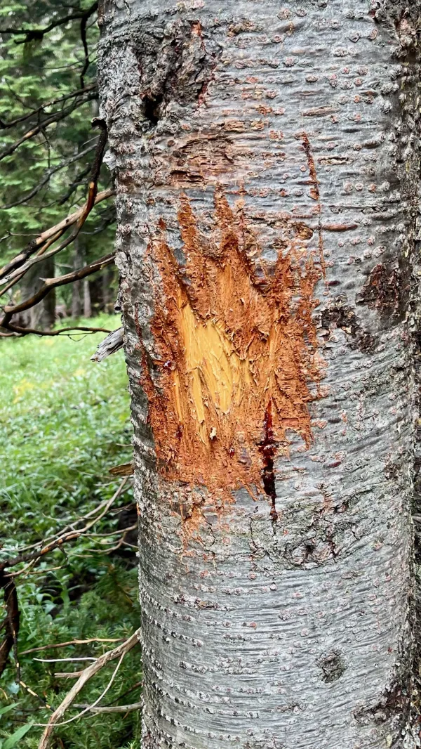
A tree that has been clawed by a bear
Though I didn't see any footprints of animals today, Top O' told me later he saw prints from a mountain lion and a bear.
There was an unmistakable sign of a large bear on a tree. The bark was severely gouged and scratched. Based on the distance between the claw marks and the depth they cut into the bark, I knew I didn't want to encounter the bear that made them.

Climbing to Eagle Pass
The steepest part of the climb to Eagle Pass began at 11 a.m., almost six miles into the hike. The next 1.5 miles would climb about 750 feet.

A family with horses at Eagle Pass
When we arrived at the top of the pass, we were soon joined by a family on horseback. A girl in the group had a birthday this weekend, and this trip was how she wanted to celebrate it.
We also met two SOBO hikers while we stopped at the pass.
A small amount of sun made it through the otherwise shaded pass, so Top O' and I spread out our gear to dry while we ate lunch.

Washakie Wilderness
Going down from the pass was slow because of mud and many rocks on the steep descent. The trail was badly eroded, and it was easy to see that horses caused most of the damage.
We were now in Washakie Wilderness, which is 693,934 acres in size. That makes it the largest wilderness area in Wyoming. It was given the name of Chief Washakie, the Shoshone tribe's leader in the latter part of the 19th century.

Eagle Creek
We had to slow down again where Eagle Creek crossed the trail. The stream wasn't wide but was filled with large boulders.
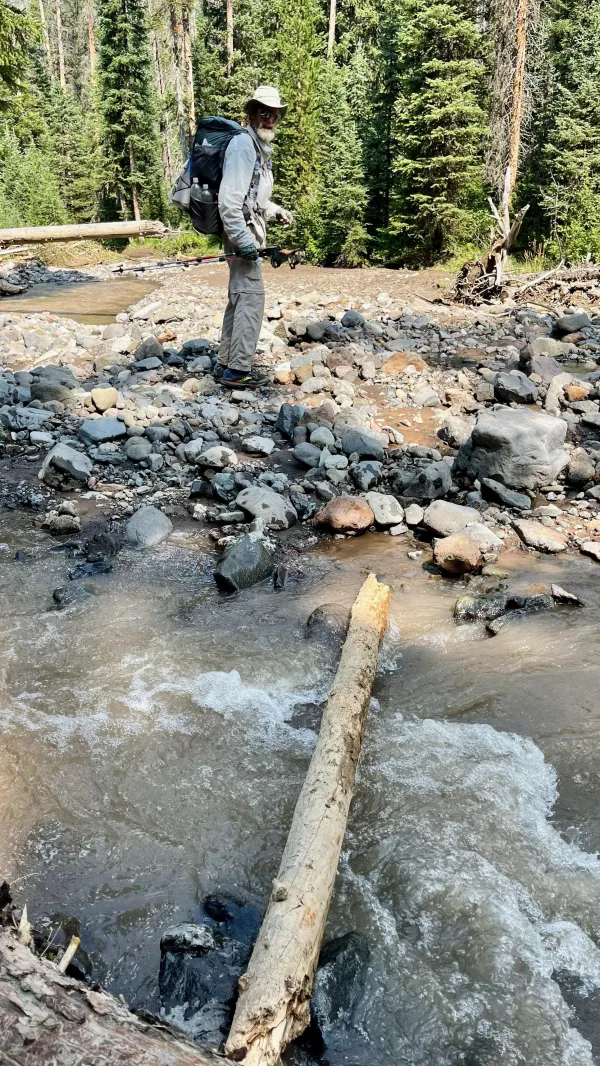
A sketchy crossing over Eagle Creek
We came to a more difficult stream crossing at 3:15 p.m. A small log laid partially across the creek was there to walk on without getting our feet wet. I was glad when Top O' went first because I could see the log was stable and wouldn't roll when stepped on.

Eagle Creek Meadow
Eagle Creek Meadow was wide and beautiful. It was bounded on both sides by wooded mountain ridges standing 2,000 feet taller than the valley floor.
We walked the length of the meadow, which was about three miles long.

Eagle Creek
About halfway through the meadow, the trail moved to the east side to stay above a large wetland.
I could barely see Sleeping Giant Mountain in the distance through the smoke. It was about 12 miles away and stood on the other side of the highway we will cross tomorrow.
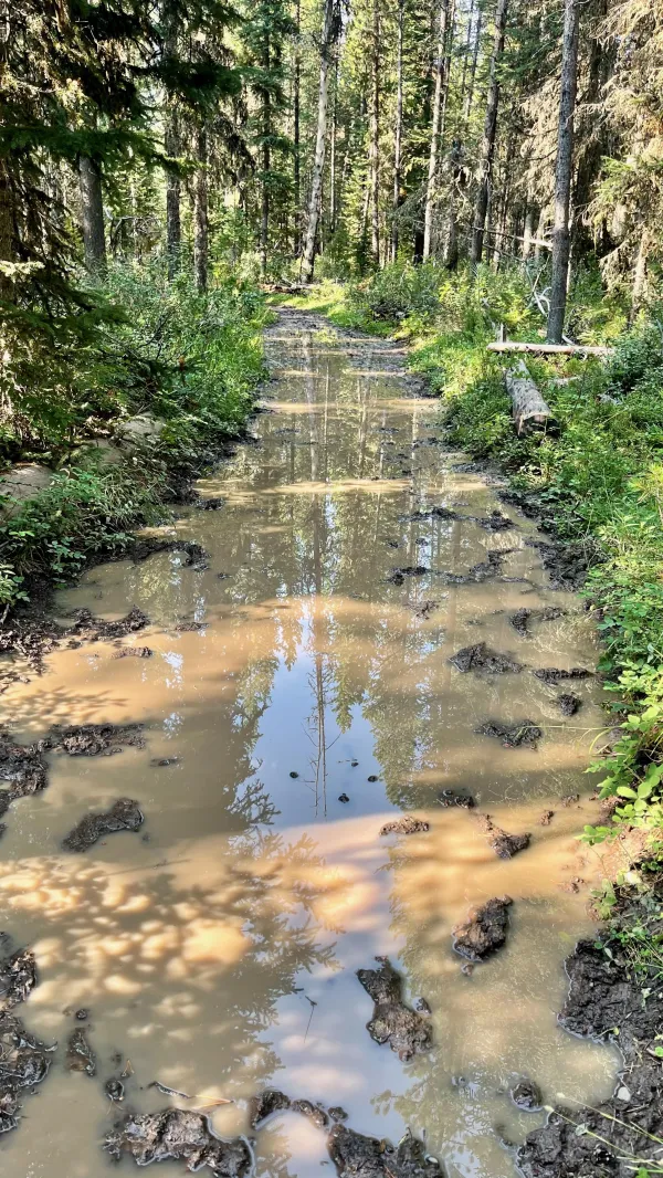
A flooded section of trail
At the end of the meadow, the trail turned to follow Eagle Creek more closely. We didn't get far before it seemed like the trail was the creek. The entire footpath was filled with water. There was no way to walk without getting our feet wet.
We stopped for dinner after we reached the other end of that long flooded section. There was room for us near the trail to sit and eat, but we hadn't found a spot so far that was suitable for camping.

Fording Eagle Creek
When we came upon another crossing of Eagle Creek after dinner, we didn't mind that we had to get our feet wet walking to the other side. We were glad for the opportunity to wash the mud off our shoes.

The trail goes above Eagle Creek
The valley became much more narrow after the crossing, and the trail went high on the steep slope above the creek. There wasn't enough space for a campsite here, but eventually, we found one.

Tents pitched on a sloping ledge
We found a spot at 7:15 p.m. on a ledge above the creek. Though it was a little sloped, we made it work. It looked like horse riders sometimes used the ledge as a campsite. A path to the creek allowed us to go down there and gather water.
Our campsite set us up in a good position for tomorrow. We were seven miles from U.S. Highway 14/16/20. When we get there, we will follow the road to where our next resupply boxes have been sent.
I was relieved to see we have a short distance to walk tomorrow. The trail was difficult for me today, and I was feeling bad about my slow pace. Negative thoughts began to creep into my head: Was I holding Top O' back? Was I starting to wear down? Could I make it all the way to Canada?
There was that doubt again. Still, as I said before, that's not always bad. It can be a reminder to make sure you're doing what you want to do. Feeling uncertain can help you find the resolve you need to move forward.
I'm still determined to finish this hike. There's no question about that.
Maybe today was just a bad day. I bet I'll feel better tomorrow after I've had a chance to eat some restaurant food.
There are times when I can help you out
And times when you must fall
There are times when you must live in doubt
And I can't help at all
This trail report was published