
Day 25 Jerry Cabin Shelter to Hogback Ridge Shelter
More from this trailAnd I feel the wind and I taste the rain
The day started promisingly. Rain had stopped and the high winds had diminished.
It continued favorably, with beautiful scenery and fascinating history, and I met some friendly people.
And the day ended miserably.
Whenever the weather is cold or rainy, I always seem to take a longer time to get going in the morning. That certainly was the case today. I didn't leave camp until 8:30 a.m.
Everything was wet, but thankfully, it wasn't raining.
For now.

Foggy trail
The sun made feeble attempts to shine, then seemed to simply give up and let the clouds take over.

Foggy meadow
After a short climb from Jerry Cabin Shelter, the trail continued to a large open meadow. The presence of a fence and a man-made pond made me wonder if this open area was once used for livestock grazing. I had hiked here two or three times before and never saw any evidence of animals. If the meadow had been used by livestock, that didn't appear to be the case now.

Hikers ahead
Hiking across the long, flat meadow was easy.
I saw a couple of hikers ahead who had camped near me last night. They were walking slower than me, and it didn't take long before I caught up to them.

Dotcom and Queen
We walked together and had a nice chat for a while. They told me they were Dotcom (pictured left) and Queen, and both were from Maryland. They were section-hiking and intended to get off the trail at Spivey Gap.
Dotcom told me she volunteers every Tuesday at the Appalachian Trail Conservancy's office in Harpers Ferry, and said I should look for her if I happened to arrive there on a Tuesday.
Harpers Ferry seemed like a long way away right now, but I filed away this information and hoped to get there when Dotcom was working in the office.

Granite memorial for Howard F. Bassette
After leaving the meadow, we found a granite memorial near the trail. It said Howard F. Bassette's ashes were scattered here following his death in 1987. He was an AT thru-hiker in 1968.
Not to be disrespectful, but I'm surprised the U.S. Forest Service allows stone markers to be placed along a trail like this. Gravestones placed before the trail was built are one thing. They are part of the historic record of the land. In my mind, and likely anyone else who tries to follow Leave No Trace principles, memorials like this one are different. They are jarringly unnatural and out of place for this setting and detract from the beauty of the area.
I'm sure the trail was important to Mr. Bassette, and placing a memorial here was meaningful to his family and friends.
Dotcom and Queen stopped near the monument because they had a cellphone signal and wanted to call their husbands. I continued down the trail.

Sign and blue blaze for bad weather bypass trail
A short distance later, I came upon a bad weather bypass trail. This was similar to the one I followed yesterday when I elected to avoid going over Big Firescald Knob in high winds.
The weather today didn't justify using the bypass route, and I stayed on the white-blazed trail.

Big Rocks section of the AT
My decision to stay on the main route turned out to be correct. This section wasn't difficult at all, and frankly, I was surprised a bad weather route was thought to be necessary. The trail was rocky, but it certainly wasn't as difficult as going over Big Firescald Knob, good weather or bad.

Near Big Butt
The trail remained mostly flat through this section, which next went past a meadow on Big Butt Mountain. Despite the recent rain, the footpath wasn't too muddy, and I was able to hike without difficulty.

Easy trail
As I mentioned before, I had already hiked this part of the trail. Even though that happened several years ago, I thought I had a good memory of this section. Still, I started to think today, "This doesn't look familiar to me."
Then I realized the trail had been relocated since I was last here.

Old farm road
I remembered walking on an old farm road when I was here before. Out of curiosity and to confirm I didn't make up this memory, I went a few yards off the trail. It didn't take long before I found the road.
It was as badly eroded as I remembered it, which explains why the trail was moved.

Side trail to Shelton graves
I had been walking a couple hours before I reached a blue-blazed side trail that led to the burial site of David Shelton, Jr., his nephew William Shelton, and a 13-year-old boy named Millard Haire.

Shelton graves
The Sheltons were Union soldiers during the Civil War. Why they were not with their unit and why Haire was with them when they were killed was unclear for several years. Some written accounts said the boy was helping the two men find their way home. A 2014 book written by a descendant of David Shelton, Jr. cleared up several details.
The author says the three were were among several people sleeping in a cabin when they were ambushed by Confederate soldiers from the 64th North Carolina Regiment, led by Lt. Col. J. A. Keith. The boy was the first to be killed.
If Haire's headstone is to be believed, the three died on July 1, 1863. Coincidentally, that was also the first day of the bloody battles that took place to the north in Gettysburg, Pennsylvania. However, Maynard Scott Shelton says in his book that the ambush happened on July 19, 1864.
The Unionist soldiers were in Tennessee after deserting from the 2nd North Carolina Mounted Infantry. They had deserted once before, then rejoined the war before deserting again.

David Shelton, Jr. gravestone
As the story goes, only two grave markers were placed here when the three were buried. That’s because the government paid for headstones of solders and not civilians. Millard Haire's family was unable to afford a stone marker, and his grave remained unmarked for several years. Two other civilians were killed during the ambush, and it's believed they are also buried nearby in unmarked graves.
I wondered if the government would pay for the headstones of deserters but wasn't able to get a clear answer. I learned, however, that the government provided the same granite markers for Union and Confederate soldiers, so it seems possible.

Millard Haire headstone
A granite headstone for Millard Haire with an apparently wrong date for his death now stands between those of the two soldiers. It was placed there in 1994.
This is a tragic but fascinating bit of U.S. history. Like so many stories of the war, however, there is much more to this one than stone markers can tell.
The ambush was connected to another sad chapter of history, which happened nearby a year earlier. It was one of the most infamous events in this area during the war.
Residents of western North Carolina and East Tennessee were much less sympathetic to the Confederacy than other Southerners. Few people around here were slave owners. They were mountain people, not plantation owners, and resented fighting a war for a cause that didn’t benefit them.
Confederates tried to coerce the locals to support their war and convince men to enlist in the army. In late 1862 and early 1863, that coercion took the form of withholding salt from residents of the Shelton Laurel community.
In January 1863, about 50 Union sympathizers from Shelton Laurel, including some who had deserted from Keith’s regiment, traveled to the county seat to retrieve their salt supply. In retaliation, Lt. Col. Keith ordered his men to Shelton Laurel. A gun battle broke out and a dozen residents were killed.
Keith then ordered his soldiers to round up 13 men and boys. They were marched toward Knoxville, Tenn., or so it seemed. The group didn’t go far.
On the way, the prisoners were ordered to halt. Then Keith ordered the men and boys executed, five at a time. The bodies of the dead were dumped in a ditch.
The retaliation continued as Confederate soldiers whipped and tortured Shelton Laurel's women.
This shocking story is known today as the Shelton Laurel Massacre.
Keith was held for two years after the war, and eventually, he was tried for the massacre. He was the only soldier involved to face trial.
Keith was convicted, but before he was sentenced, he escaped from jail.
Days later, the state supreme court handed down a decision vindicating Keith, believing his claim that he had been ordered by Major General Henry Heth to kill the Union sympathizers.

Red eft
I came across a red eft after leaving the grave site. It's not unusual to see them on the trail.
A red eft is a juvenile eastern newt, which is a common resident of the trail and the eastern part of the U.S. At this stage in its life, it lives on land, but later as it matures, it will lose its bright color and change to a dull yellow-green. An adult eastern newt will prefer to live near a small lake or stream.
I always thought a brightly colored creature as this would be easy prey for other animals and was surprised to find them so often in the open. I later learned their skin has a neurotoxin that protects them against predators.
Newts can live 12 to 15 years.

Fallen tree
From time to time today, I had to walk around or across trees lying across the trail. These were recent blowdowns and were likely the result of yesterday's high winds.
The trail maintenance volunteers from the Carolina Mountain Club will be kept busy for a while.
I stopped for lunch at Flint Mountain Shelter. Dotcom and Queen arrived a short time later. I also met Data and Rambo while I was there.
I asked Rambo if she got her name because she was super tough. Her answer made me laugh.
"No," she said, "it's because I carry a large knife."
The weather became noticeably colder while I was at the shelter. Then as I prepared to leave, it began to rain.
The rain remained steady for much of the afternoon. At one point, I thought it stopped falling and paused to take off my rain jacket. As soon as I did, the rain started again.
Data passed me on the trail, pausing long enough to tell me he was hiking with a hiker named Juice, whose gear got soaked in last night's rain. Data asked if I saw Juice to pass along a message that he was planning to go the hostel at Rector Laurel Road.

Rain at Devil's Fork Gap
Juice caught up to me when I arrived at Devil's Fork Gap, and I passed along Data's message. Just then, a beat up, rattly truck pulled up.
The driver asked us, "Are you the guy with the blisters?"
Neither one of us confessed to having that problem, but Juice decided to let the guy drive him to the hostel.
Rector Laurel Road was a short distance over the next hill, and when I got there, I ran into Data again. This gave me a chance to complete the communication loop by telling him Juice was already headed to the hostel.
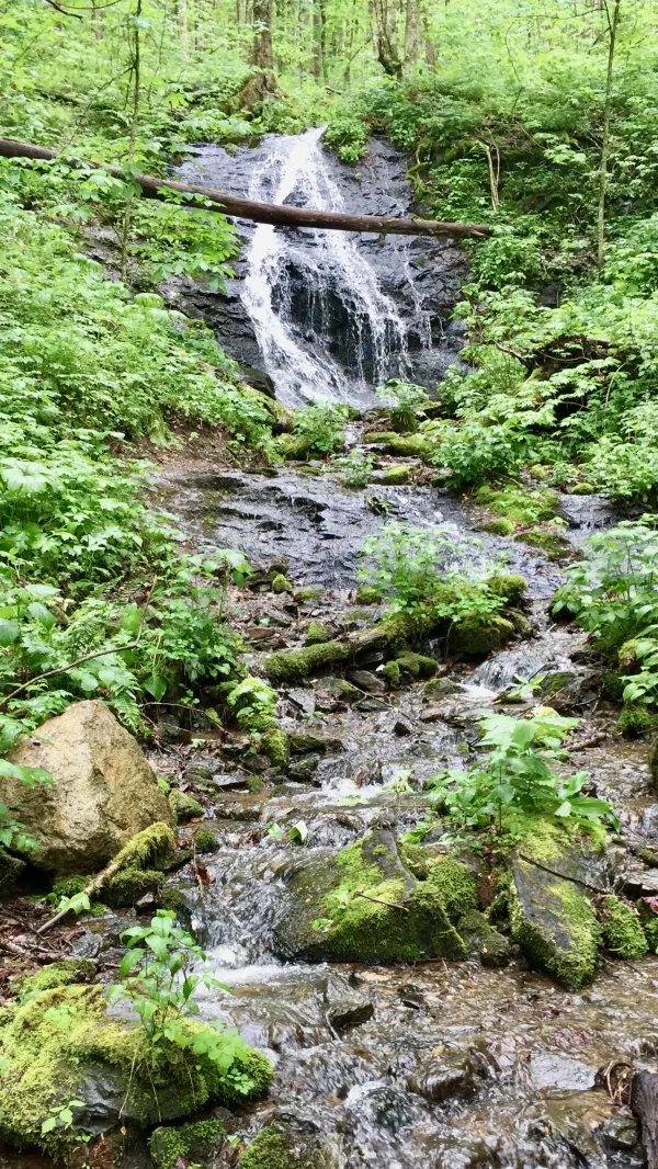
Cascade on Sugarloaf Branch
After the trail crossed the road, it began a long climb and followed a stream called Sugarloaf Branch.
Before the trail turned away from the stream, it passed a lovely cascading waterfall. The rain had let up a bit, so I stopped for a couple minutes to enjoy it.

False Solomon's Seal
The forest floor along the trail was thick with foliage. False Solomon's Seal was one of many plants to carpet the area in green and white.

A carpet of green
May apple was another plant that seemed to cover any space that wasn't the footpath. Despite the rain, or maybe because of it, the entire forest looked like it had been painted in the same deep shade of green.

Trail to Hogback Ridge Shelter
The trail climbed more than 1,500 feet to the top of Divide Mountain, then quickly lost nearly half of that elevation gain.
The descending side of the mountain was far less green. The foliage wasn't nearly as thick.
At any rate, I was no longer interested in looking at the scenery because I was starting to feel the cold and wet seep through my rain gear and into my clothes.

Survey marker in the trail
Despite the increasingly miserable conditions, I stopped when I saw something in the trail. It turned out to be a survey marker.
Why was a marker in the middle of the trail? I wish I knew. It was an unnecessary trip hazard, and it seems like the trail could have been easily routed a couple feet to the left or right to go around it.
When I got to Rice Gap, where an ATV trail crossed the AT, the trail began another ascent. Rain began to fall again and the temperature continued to drop. I was no longer just cold and wet, I was becoming impatient. The next shelter was not appearing soon enough.
Naturally, it's times like this when the trail seems to never reach the end.
I was shivering and pathetic when I finally reached Hogback Ridge Shelter. Hypothermia was a real concern at this point. I needed to get out of my wet clothes and get some warm food into me as soon as possible.
The shelter was crammed with wet hikers, so there was no room for me. Someone mentioned a new hostel had just opened near Sam's Gap, just 2.3 miles down the trail, and that seemed like it could be the best solution for my increasingly dire circumstances. I decided to call and see if there was room for me.
So many people were in and standing near the shelter that I couldn't get completely out of the rain to make the call. I was shivering so much, it took a couple of attempts to dial my phone. When I finally did, the connection was bad, and I had to try a couple more times before reaching the hostel.
It was full.
Left with no other choice, I pitched my tent and set off to get water. There again was a problem. The water source for this shelter was down a long trail. It was so far away, I felt like I was walking back to the last shelter. The distance to the spring was said to be a quarter mile, but it felt like it had to be much farther.
The only fortunate part of walking to the spring was I began to get warmer. By the time I got back to the shelter, I wasn't suffering quite as much and was able to prepare my dinner.
After eating warm food, I hung my bear bag on one of the cables provided near the shelter, got into my tent, and at last changed into dry clothes. Though I avoided hypothermia and was now feeling better, I was still miserable.
Comes a time when the blind man takes your hand
Says, "Don't you see?
Gotta make it somehow on the dreams you still believe
Don't give it up, you got an empty cup
That only love can fill, only love can fill"
Been walkin' all mornin', went walkin' all night
I can't see much difference between the dark and light
And I feel the wind and I taste the rain
Never in my mind to cause so much pain
This trail report was published